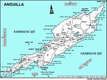

Road Salt Pond, also known as Road Bay Pond or simply Road Pond, is a wetland in Anguilla, a British Overseas Territory in the Caribbean Sea. It is one of the territory's Important Bird Areas (IBAs).
Road Salt Pond, also known as Road Bay Pond or simply Road Pond, is a wetland in Anguilla, a British Overseas Territory in the Caribbean Sea. It is one of the territory's Important Bird Areas (IBAs).
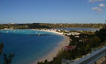
Road Salt Pond is a circular, 43 ha lagoon. It is the largest enclosed body of water on the island. It lies in the Sandy Ground district near the north-west coast of the main island. The dunes separating it from the sea at Road Bay on its western side have been flattened and built upon. It is bordered on the north and south by low hills supporting low dry forest and scrub as well as residential housing. [1]
The IBA was identified as such by BirdLife International because it is a breeding site for least terns (with up to 123 birds recorded), as well as supporting populations of Caribbean elaenias, pearly-eyed thrashers and Lesser Antillean bullfinches. [1]
The pond has a long history of being used to produce salt, and the remains of saltworks infrastructure are visible around its edge. More recently, parts of the pond have been reclaimed for road construction and parking space. [1]

Anegada is the northernmost of the British Virgin Islands (BVI), a group of islands that form part of the archipelago of the Virgin Islands. It lies approximately 15 miles (24 km) north of Virgin Gorda. Anegada is the only inhabited British Virgin Island formed from coral and limestone, rather than being of volcanic origin. While the other islands are mountainous, Anegada is flat and low. Its highest point is only about 28 feet (8.5 m) above sea level, earning it its name, which is the Spanish term for the flooded land, "tierra anegada".
Great Pond is a 50 ha saline coastal lagoon on the south-eastern shoreline of the island of Saint Croix in the United States Virgin Islands. The pond is part of St Croix East End Marine Park. It the second largest salt pond in the Virgin Islands, and is one of the largest remaining mangrove tracts in St. Croix.

The Bluff is the highest part of the Cayman Islands, a British Overseas Territory in the Caribbean Sea. It stands at the eastern end of the island of Cayman Brac and has a maximum elevation of 43 m (141 ft).

Long Pond, also known as Long Salt Pond, is a 23 ha brackish lagoon on the central south-eastern coast of the main island of Anguilla, a British Overseas Territory in the Caribbean. About 1.2 km long, it is separated from the sea at its eastern end by sand dunes. Its south shore is separated from the sea by a 300 m wide strip of scrub vegetation on limestone. The area to the north and west is residential.

Booby Pond Nature Reserve is a protected wetland on Little Cayman, one of the Cayman Islands, a British Overseas Territory in the Caribbean Sea.
The Central Manrove Wetland is a large area of mangrove dominated wetland on Grand Cayman, one of the Cayman Islands, a British Overseas Territory in the Caribbean Sea. It is one of the territory's Important Bird Areas (IBAs).
The Crown Wetlands lie on Little Cayman, one of the Cayman Islands, a British Overseas Territory in the Caribbean Sea. Collectively they form one of the territory's Important Bird Areas (IBAs).
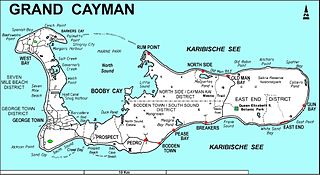
The Eastern Dry Forest lies at the eastern end of Grand Cayman, one of the Cayman Islands, a British Overseas Territory in the Caribbean Sea. It is one of the territory's Important Bird Areas (IBAs).
Mastic Reserve lies at the eastern end of the North Side of Grand Cayman, one of the Cayman Islands, a British Overseas Territory in the Caribbean Sea. It, with the associated Mastic Trail, is managed by the National Trust for the Cayman Islands and is one of the territory's Important Bird Areas (IBAs). It is named after the yellow mastic and black mastic trees which occur in the reserve.
Cauls Pond is a wetland in Anguilla, a British Overseas Territory in the Caribbean Sea. It is one of the territory's Important Bird Areas (IBAs).
West End Pond is a wetland in Anguilla, a British Overseas Territory in the Caribbean Sea. It is one of the territory's Important Bird Areas (IBAs).
Rendezvous Bay Pond, also known as Rendezvous Bay Salt Pond, is a wetland in Anguilla, a British Overseas Territory in the Caribbean Sea. It is one of the territory's Important Bird Areas (IBAs).
Meads Bay Pond is a wetland in Anguilla, a British Overseas Territory in the Caribbean Sea. It is one of the territory's Important Bird Areas (IBAs).
The Merrywing Pond System is a golf course wetland system in Anguilla, a British Overseas Territory in the Caribbean Sea. It forms one of the territory's Important Bird Areas (IBAs).
Forest Bay Pond is a small wetland in Anguilla, a British Overseas Territory in the Caribbean Sea. It forms one of the territory's Important Bird Areas (IBAs).

The Northern Forested Ghauts constitute a tract of land on the island of Montserrat, a British Overseas Territory in the Leeward Islands of the Caribbean Sea. It forms one of the territory's Important Bird Areas (IBAs).

The Fish Ponds and Crossing Place Trail Important Bird Area is a 1024 ha tract of land on the island of Middle Caicos in the Turks and Caicos Islands, a British Overseas Territory in the Lucayan Archipelago of the western Atlantic Ocean. It forms one of the territory's Important Bird Areas (IBAs).

Fresh Pond is a 14 ha water body in Sint Maarten on the island of Saint Martin. It has been identified as an Important Bird Area by BirdLife International because it supports populations of various threatened or restricted-range bird species. Some 2.5 km long by 1 km across, it lies within the capital city of Philipsburg. Because of its low salinity, it supports species which are less common in other parts of the island. The pond is bordered with reeds, mangroves and coconut palms. American coots have been recorded breeding at the site, as well as snowy egrets, pied-billed grebes, common moorhens, great egrets, white-cheeked pintails and ruddy ducks. Other birds for which the IBA was designated include green-throated caribs, Antillean crested hummingbirds, Caribbean elaenias, pearly-eyed thrashers and lesser Antillean bullfinches.
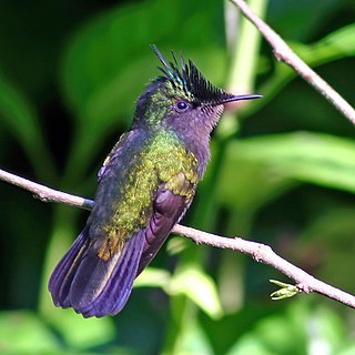
Little Bay is an 8-hectare (20-acre) coastal pond in the country of Sint Maarten on the island of Saint Martin in the Dutch Caribbean. It has a low salinity and lies near the capital, Philipsburg. It has been identified as an Important Bird Area by BirdLife International because it supports threatened or restricted-range bird species. Birds for which the IBA was designated include green-throated caribs, Antillean crested hummingbirds, Caribbean elaenias, pearly-eyed thrashers and lesser Antillean bullfinches. Pied-billed grebes, common moorhens, American coots, white-cheeked pintails and ruddy ducks have been recorded nesting at the site.
18°12′12″N63°05′23″W / 18.20333°N 63.08972°W
| | This Anguilla location article is a stub. You can help Wikipedia by expanding it. |