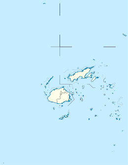
Fiji, officially the Republic of Fiji, is an island country in Melanesia, part of Oceania in the South Pacific Ocean. It lies about 1,100 nautical miles north-northeast of New Zealand. Fiji consists of an archipelago of more than 330 islands—of which about 110 are permanently inhabited—and more than 500 islets, amounting to a total land area of about 18,300 square kilometres (7,100 sq mi). The most outlying island group is Ono-i-Lau. About 87% of the total population of 924,610 live on the two major islands, Viti Levu and Vanua Levu. About three-quarters of Fijians live on Viti Levu's coasts, either in the capital city of Suva, or in smaller urban centres such as Nadi or Lautoka. The interior of Viti Levu is sparsely inhabited because of its terrain.

Fiji is a group of volcanic islands in the South Pacific, lying about 4,450 kilometres (2,765 mi) southwest of Honolulu and 1,770 km (1,100 mi) north of New Zealand. Of the 332 islands and 522 smaller islets making up the archipelago, about 106 are permanently inhabited. The total land size is 18,272 km2 (7,055 sq mi). It has the 26th largest Exclusive Economic Zone of 1,282,978 km2 (495,361 sq mi).

Tobago is an island and ward within the Republic of Trinidad and Tobago. It is located 35 kilometres (22 mi) northeast of the larger island of Trinidad and about 160 kilometres (99 mi) off the northeastern coast of Venezuela. It lies to the southeast of Grenada.

Vanua Levu, formerly known as Sandalwood Island, is the second largest island of Fiji. Located 64 kilometres to the north of the larger Viti Levu, the island has an area of 5,587.1 square kilometres (2,157.2 sq mi) and a population of 135,961 as of 2007.

Lautoka is the second largest city in Fiji. It is on the west coast of the island of Viti Levu, in the Ba Province of the Western Division. Lying in the heart of Fiji's sugar cane-growing region, the city has come to be known as the Sugar City. Covering an area of 32 square kilometres, it had a population of 71,573 at the 2017 census, the most recent to date.
Viti Levu is the largest island in the Republic of Fiji. It is the site of the nation's capital, Suva, and home to a large majority of Fiji's population.

Savusavu is a town in the Fijian Province of Cakaudrove. The town is located on the south coast of Vanua Levu Island and had a population of 3,372 in the 2007 census.
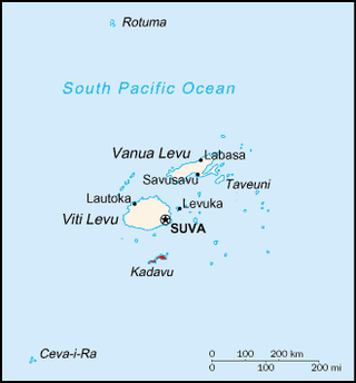
Kadavu, with an area of 411 square kilometres (159 sq mi), is the fourth largest island in Fiji, and the largest island in the Kadavu Group, a volcanic archipelago consisting of Kadavu, Ono, Galoa and a number of smaller islands in the Great Astrolabe Reef. Its main administrative centre is Vunisea, which has an airport, a high school, a hospital, and a government station, on the Namalata Isthmus where the island is almost cut in two. Suva, Fiji's capital, lies 88 kilometres to the north of Kadavu. The population of the island province was 10,167 at the most recent census in 2007.

Taveuni is the third-largest island in Fiji, after Viti Levu and Vanua Levu, with a total land area of 434 square kilometres. The cigar-shaped island, a massive shield volcano which rises from the floor of the Pacific Ocean, is situated 6.5 kilometres east of Vanua Levu, across the Somosomo Strait. It belongs to the Vanua Levu Group of islands and is part of Fiji's Cakaudrove Province within the Northern Division.

Wakaya is a privately owned island in Fiji's Lomaiviti Archipelago. Situated at 17.65° South and 179.02° East, it covers an area of 8 square kilometres (3.1 sq mi). It is 18 kilometres (11 mi) to the east of Ovalau, the main island in the Lomaiviti Group. Two other islands close to Wakaya are Makogai to the north, and Batiki to the south-east.

Beqa is an island in Fiji, an outlier to the main island of Viti Levu, 10 kilometres to the south. The island has a land area of 36.3 square kilometres and reaches a maximum elevation of 440 metres. Beqa has 9 villages divided between 2 tikinas (districts): Sawau and Raviravi. To the west is the island of Yanuca.
Nadroga-Navosa is one of the fourteen provinces of Fiji and one of eight based in Viti Levu, Fiji's largest island. It is about 2,385 square kilometers and occupies the South-West and Central areas of Viti Levu, Fiji's principal island. The province includes the Mamanuca Archipelago,Malolo Islands, off the west coast of Viti Levu, Vatulele, as well as the remote Conway Reef in the southwest. The population at the 2017 census was 58,931, being the fifth largest province. The main town in Nadroga-Navosa is Sigatoka, with a population of 9622.
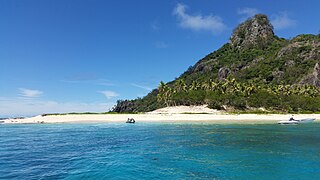
Monuriki is a small, uninhabited island situated off the coast of Viti Levu in the Fiji Islands, in Melanesia in the South Pacific Ocean. Monuriki is part of the Atolls islands, and related to a group of three islets in the larger group of islands known as the Mamanuca Islands. This coral and volcanic island is the smallest islet and the southernmost of a small group of three islets, west of Tavua.

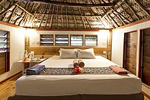
Tavarua is an island resort in Fiji. It has an area of 29 acres (120,000 m2). It is close to the main Fijian island, Viti Levu, and is surrounded by a coral reef. It is also known to be shaped, somewhat, like a heart.
Vorovoro is an island in the province of Macuata in the Vanua Levu Group of northern Fiji, 40 minutes away from the town of Labasa by boat.
The 1953 Suva earthquake occurred on 14 September at 00:26 UTC near Suva, Fiji, just off the southeast shore of Viti Levu. This earthquake had an estimated magnitude of 6.8 and 6.4. The earthquake triggered a coral reef platform collapse and a submarine landslide that caused a tsunami. Eight people were reported killed; a wharf, bridges, and buildings were severely damaged in Suva.

Severe Tropical Cyclone Sina was the only named tropical cyclone to develop within the South Pacific basin during the 1990–91 season. The system was first noted as a shallow depression within the South Pacific Convergence Zone to the west of Wallis Island. Over the next three days the system moved towards the west-northwest, before it was named Sina during November 24, after it had developed into a tropical cyclone. Over the next couple of days the system intensified further and developed an eye feature as it erratically moved towards Fiji. Sina subsequently peaked in intensity during November 26, before the system passed through the Fijian Islands over the next two days as it started to gradually weaken. Sina subsequently passed just to the north of Tongatapu in Tonga during November 29, before it passed about 160 km (100 mi) to the south of Niue and near the Southern Cook Islands during the next day. The system subsequently rapidly weakened and became an extratropical cyclone during December 1, before they were absorbed by an advancing trough of low pressure near 50°S on December 4.
The architecture of Fiji has its own unique style and pattern. While Fiji is a famous travelling destination among tourists for its beaches and beauty, its architecture is unique and particularly attractive. Fiji is a pacific island belonging to the scope of tropical marine climate, whose capital and the country's largest city is Suva. As a coastal city, the main architectural style of the urban centre, Suva has a foreign classical beauty, antique as if back to a few centuries ago. It often reflects the socio-cultural heritage of the locale and the country. However, with the development in the society of Fiji and the spread of globalization, the architectural scenario has incorporated several foreign styles without affecting the original style and yet enhancing the aesthetic value. The richness of Fiji's architecture can be comprehended from diverse styles of architectural designs for different kinds of buildings. Moreover, the architecture of the country changes with region to region and has varied influences. Additionally, it is notable that the architecture of this country can provide insights to the architects around the world regarding the aesthetically appealing patterns and scientifically viable designs which would enhance the significance of the built environments.

Matamanoa is a small, private island within the Mamanuca Islands of Fiji in the South Pacific. The islands are a part of the Fiji's Western Division.

Beachcomber is a small, private island within the Mamanuca Islands of Fiji in the South Pacific, which in turn are a part of Fiji's Western Division.