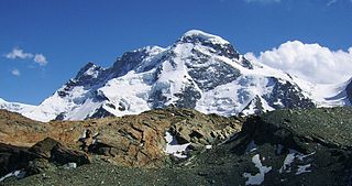
The Breithorn is a mountain range of the Pennine Alps with its highest peak of the same name, located on the border between Switzerland and Italy. It lies on the main chain of the Alps, approximately halfway between the Matterhorn and Monte Rosa and east of the Theodul Pass. Most of the massif is glaciated and includes several subsidiary peaks, all located east of the main summit: the Central Breithorn, the western Breithorn Twin, the Gendarm and the Roccia Nera. The main summit is sometimes distinguished by the name Western Breithorn. The nearest settlements are Zermatt (Valais) and St-Jacques.
The Breithorn is a mountain located in the Pennine Alps on the border between Switzerland (Valais) and Italy.
The massif des Cerces is a region of the French Alps on the Franco-Italian border. On the French side it lies in the departements of Hautes-Alpes and Savoie.

Castor is a mountain in the Pennine Alps on the border between Valais, Switzerland and the Aosta Valley in Italy. It is the higher of a pair of twin peaks, the other being Pollux, named after the Gemini twins of Roman mythology. Castor's peak is at an elevation of 4,223 m (13,855 ft), and it lies between Breithorn and the Monte Rosa. It is separated from Pollux by a pass at 3,847 m (12,621 ft), named Passo di Verra in Italian and Zwillingsjoch in German.

The Central Breithorn is a peak of the Breithorn range in the Pennine Alps, located on the border between Switzerland and Italy, between the canton of Valais and the region of Aosta Valley. It is located east of the main summit of the Breithorn and west of the western Breithorn Twin.

The Eastern Breithorn but also referred as the western Breithorn Twin, is a peak of the Pennine Alps, located on the border between Switzerland and Italy, between the canton of Valais and the region of Aosta Valley. It is part of the Breithorn range, located east of the Theodul Pass. It lies between the Central Breithorn and its other twin, the Gendarm. On its north side it overlooks the Breithorn Glacier.
The Gendarm, but also known as eastern Breithorn Twin is a peak of the Pennine Alps, located on the border between Switzerland and Italy, between the canton of Valais and the region of Aosta Valley. It is part of the Breithorn range, located east of the Theodul Pass. It is located just east of its other twin, the western Breithorn Twin, and west of the Roccia Nera.
The silver age of alpinism is the name given in the United Kingdom to the era in mountaineering that began after Edward Whymper and party's ascent of the Matterhorn in 1865 and ended with W. W. Graham and party's ascent of the Dent du Géant in 1882.

The Breithorn, is a mountain of the Bernese Alps, located on the border between the Swiss cantons of Bern and Valais. It is part of the border between Lauterbrunnental and the Lötschental. It lies approximately halfway between the Tschingelhorn and the Grosshorn.

The Breithorn is a mountain of the Bernese Alps, located east of Blatten in the canton of Valais. It lies between the Bietschhorn and the Schinhorn, on the range separating the Lötschental from the main Rhone valley (south). Its summit is the tripoint between the Lötschental and two other smaller valleys: the Baltschiedertal and the valley of the Beichgletscher.

The Breithorn is a mountain of the Swiss Lepontine Alps, overlooking Simplon in the canton of Valais. It is part of the Monte Leone massif.

Gobba di Rollin is a mountain of the Pennine Alps, straddling the border between Switzerland and Italy. It is located south of the Breithorn and it is largely covered by ice, the summit area being particularly flat. On the north side is the Breithorn Plateau of the Theodul Glacier, on the east side is the Verraz Glacier and on the south is the Glacier d'Aventine.

Theodul Pass, elevation 3,295 metres (10,810 ft), is a high mountain pass across the eastern Pennine Alps, connecting Zermatt in the Swiss canton of Valais and Breuil-Cervinia in the Italian region of Aosta Valley. Theodul Pass is the lowest and the easiest pass between the valleys of Zermatt and Valtournanche.
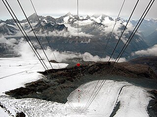
The Theodul Glacier is a glacier of the Alps, located south of Zermatt in the canton of Valais. It lies on the Swiss side of the Pennine Alps, although its upper basin touches the Italian region of the Aosta Valley. The glacier descends from the west side of the Breithorn and splits into two diverging branches above Gandegg: the Upper Theodul Glacier, spilling on a high plateau near Trockener Steg, together with the Furgg Glacier, and the Lower Theodul Glacier, reaching a height of about 2,500 metres (8,202 ft) above the Gorner Glacier. Both branches are part of the Rhone basin, through the rivers Gornera, Mattervispa, and Vispa. Slightly above the glacier splitting is the Theodul Pass, crossing the border between Switzerland and Italy, and connecting Zermatt to Breuil-Cervinia. On the west, the Theodul Glacier is overlooked by the Matterhorn.
The Breithorn Twins are twin peaks of the Breithorn range of the Pennine Alps, located on the border between Switzerland and Italy, between the canton of Valais and the region of Aosta Valley. It is located east of the Theodul Pass.
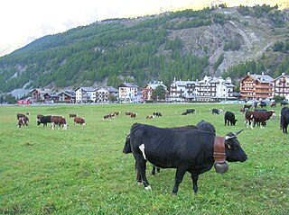
The Valdostana Pezzata Nera is an Italian breed of cattle from Valle d'Aosta region in north-western Italy. It is black-pied, with short horns. It is one of three regional breeds in the area, the others being the Valdostana Castana and the Valdostana Pezzata Rossa. Like them, it derives from inter-breeding of various local breeds and types of cattle. It appears to have been most influenced by the Swiss Fribourgeoise and Hérens breeds, which came into the Valle d'Aosta over the Great St. Bernard Pass. The Valdostana Pezzata Nera is a dual-purpose breed, raised mainly for milk, but also for meat. Management is normally transhumant: the cattle are stabled only in winter, and spend the summer months on the mountain pastures of the Alps.

The Punta Nera is a mountain of Savoie (France) and of the Province of Turin (Italy). It lies in the Cottian Alps range. It has an elevation of 3,047 metres above sea level.

The Black Hand is a 1968 French-Italian crime thriller film directed by Max Pécas and starring Janine Reynaud, Chantal Nobel and Jean Topart.

Ulrich Almer was a Swiss mountain guide, born on 8 May 1849 in Grindelwald where he died on 4 September 1940. He made many premieres in the Alps, at the beginning with his father Christian Almer, one of the great guides of the golden age of mountaineering, and was one of the first Swiss guides to visit the Caucasus.

