Jackson Heights is a neighborhood in the northwestern portion of the borough of Queens in New York City. The neighborhood is part of Queens Community Board 3. Jackson Heights is neighbored by North Corona to the east, Elmhurst to the south, Woodside to the west, northern Astoria (Ditmars-Steinway) to the northwest, and East Elmhurst to the northeast. The main ZIP code of Jackson Heights is 11372. According to the 2010 United States Census, the neighborhood has a population of 108,152.

Jamaica is a middle-class neighborhood in the New York City borough of Queens. The neighborhood is part of Queens Community Board 12, which also includes Hollis, St. Albans, Springfield Gardens, Baisley Pond Park, Rochdale Village, and South Jamaica. The NYPD's 103rd, 113th & 105th Precincts patrol Jamaica.

Mid-Wilshire is a neighborhood in the central region of Los Angeles, California. It is known for the Los Angeles County Museum of Art, the Petersen Automotive Museum, and the Miracle Mile shopping district.
Pulaski Heights is a section of the city of Little Rock, Arkansas, located in the north-central portion of the city. The area comprises two distinct neighborhoods representing an historic suburb dating from the 1890s that was among the first areas to be annexed into Little Rock.

University Heights is a neighborhood in Central San Diego, California centered on Park Boulevard and Adams Avenue. According to the City of San Diego Assessor/Recorder/County Clerk parcel maps, University Heights is bounded on the west and north by the edge of the mesa, the southern boundary is Lincoln Avenue, and the eastern boundary is Boundary Street along the western edge of Interstate 805. The area is filled with a number of restaurants, coffee shops, boutiques, and artist studios primarily on Park Boulevard and Adams Avenue. Live entertainment can be found most nights. Adjacent to Hillcrest, Normal Heights and North Park, additional restaurants, bars, coffee shops, and night clubs are within easy reach.
Whitley Heights is a residential neighborhood and historic preservation overlay zone in the Hollywood Hills neighborhood of Central Los Angeles, California. Known as a residential area for actors and other people in the motion-picture industry, it is divided between a hillside single-family district and an apartment area. It is notable for an attempt by its homeowners' group and the city to close off public streets to outside traffic, an effort that was ruled illegal by the courts

There are more than 500 neighborhoods within the area of Jacksonville, Florida, the largest city in the contiguous United States by area. These include Downtown Jacksonville and surrounding neighborhoods. Additionally, greater Jacksonville is traditionally divided into several major sections with amorphous boundaries: Northside, Westside, Southside, and Arlington, as well as the Jacksonville Beaches.

LaFayette Square is a historic semi-gated neighborhood in the central region of Los Angeles, California.

The Old Fourth Ward, often abbreviated O4W, is an intown neighborhood on the eastside of Atlanta, Georgia, United States. The neighborhood is best known as the location of the Martin Luther King, Jr. historic site.

The neighborhoods of Albany, New York are varied demographically, geographically, architecturally, and historically. Downtown Albany is the city's oldest neighborhood, centered on State Street, one of Albany's oldest streets and its original main street. North and south of Downtown Albany are old residential communities often consisting of row houses; to the north, those neighborhoods include Sheridan Hollow, Arbor Hill, and North Albany, while to the south is the super-neighborhood of the South End, which includes several smaller neighborhoods.

Squier Park is a historic neighborhood in midtown Kansas City, Missouri, USA. It encompasses sixteen blocks bounded by Armour Boulevard on the north, 39th Street on the south, Troost Avenue on the west, and Paseo Boulevard on the east. It is primarily a residential neighborhood, with businesses along Troost Avenue. It has been listed on the National Register of Historic Places since 2012.

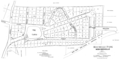
The Rochelle Park–Rochelle Heights Historic District is a historic residential district located in the city of New Rochelle in Westchester, New York. The district is historically and architecturally significant as an intact and distinctive example of residential park development at the turn of the Twentieth Century. It includes the historic Rochelle Park development, and the later Rochelle Heights subdivision. Within the district are 555 contributing properties, including 513 buildings, 38 structures, and 4 sites. Only 24 buildings and 1 site separately identified within its area are non-contributing. It was listed on the National Register of Historic Places (NRHP) on July 6, 2005.
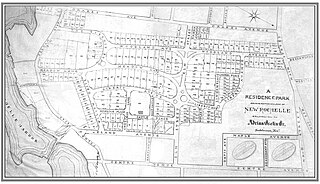
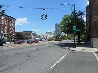
Residence Park is a historic community located in the city of New Rochelle, in Westchester County, New York. It is one of the first planned residential parks, and garden city communities, in the United States. It is located in the southern section of the city, bordered by Neptune Park on the west, Shore Road and Long Island Sound on the south, and Downtown New Rochelle on the north.

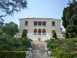
Beechmont is an upscale residential community located in the northern end of New Rochelle in Westchester County, New York. Its boundaries are the town of Mamaroneck on the east, by Rochelle Heights on the south, by Huguenot Park on the west and by Forest Heights and Bayberry on the north. Beechmont is within the larger Wykagyl sub-section of New Rochelle, served by the 10804 zip-code. The United States Board on Geographic Names recognizes Beechmont as the official common name for the neighborhood, which it defines as a populated place existing within the incorporated City of New Rochelle.
Pelham Road, known as Shore Road within the Bronx, is a historic 4.1-mile (6.6 km) east-west arterial road that runs along the Long Island Sound shoreline from Pelham Bay Park in the Bronx through the southern Westchester County, New York communities of New Rochelle and Pelham Manor. The thoroughfare had its beginning as an Native American trail linking the important villages on Davenport Neck to those on Pelham Neck in Pelham. Between these points along the shore line there was an almost continuous chain of small Indian villages and camps. This waterfront area was especially advantageous, with many small coves in secure harbors and protected by adjacent islands and many small streams of water and abundant springs.

The historic Chicago park and boulevard system is a ring of parks connected by wide, planted-median boulevards that winds through the north, west, and south sides of the City of Chicago. The neighborhoods along this historic stretch include, Logan Square, Humboldt Park, Englewood, Back of the Yards, Lawndale, and Bronzeville. It reaches as far west as Garfield Park and turns south east to Douglas Park. In the south, it reaches Washington Park and Jackson Park, including the Midway Plaisance, used for the 1893 World's Fair.