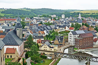
Rochlitz is a major district town in the district of Mittelsachsen, in Saxony, Germany. Rochlitz is the head of the "municipal partnership Rochlitz" with its other members being the municipalities of Königsfeld, Seelitz and Zettlitz.

The 140-kilometre-long road, the Silver Road is the first and longest holiday route in the German Free State of Saxony. Against the background of the importance of mining in the history of Saxony, the road links those sights and tourist attractions of the Ore Mountains and its foreland that relate to the centuries-old mining and smelting industries of the region.
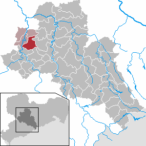
Seelitz is a municipality in the district of Mittelsachsen, in Saxony, Germany. It is part of the administrative partnership Verwaltungsgemeinschaft Rochlitz based in the eponymous town.

Bieleboh is a mountain in the Lusatian Highlands, in the east of Saxony, Germany. Its summit is located on the grounds of Beiersdorf municipality.

Hirtstein is a mountain of Saxony, in southeastern Germany. It is situated near the village Satzung, in the Ore Mountains, about 1.5 km from the border to the Czech Republic. Its elevation is 890 m.

The Ore Mountain passes are crossings and passages over the crest of the Ore Mountains in Central Europe, over which tracks, roads, railway lines and pipelines run from the Free State of Saxony in the Federal Republic of Germany to Bohemia in the Czech Republic and vice versa.

Eisenhammer Dorfchemnitz is an historic hammer mill in Dorfchemnitz in the Ore Mountains of Germany. The mill is an important witness to proto-industrial development in the Ore Mountains. Of the once-numerous hammer mills only three others remain working in Saxony apart from the Frohnauer Hammer: the Frohnauer Hammer Mill, the Grünthal Copper Hammer Mill and the Freibergsdorf Hammer Mill.
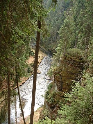
The Kirnitzsch (German), in Bohemia also called the Kirnischt, Czech: Křinice, is a right tributary of the River Elbe, which passes through the Czech Republic and the German state of Saxony.

The so-called Saukrieg of 1555–1558 was a feud between John of Carlowitz and Zuschendorf and the Bishop of Meißen, John IX of Haugwitz. During the course of the feud, Carlowitz had 700 pigs, belonging to the bishop's subjects, driven away in order to pursue his claims, which explains the rather unusual name of the feud. The Saukrieg has been described as the last feud "in the spirit of the Middle Ages".
The Schwarzbach railway was a 750 mm Saxon narrow-gauge railway in Saxon Switzerland. It began in Goßdorf-Kohlmühle station on the Sebnitz Valley railway and ran along the valley of the Schwarzbach to Hohnstein.

Kriebstein Castle is a castle in Kriebstein near the town of Waldheim in the German state of Saxony.

Scharfenstein Castle lies on an elongated hill spur above the village of Scharfenstein, in the municipality of Drebach in the Ore Mountains of Saxony, Germany. The castle is one of 24 sites run by the state-owned State Palaces, Castles and Gardens of Saxony.
The Holy Way came about as a result of the canonization of Bishop Benno of Meissen. It led from Bohemia to Meissen and ran between Grillenburg and Wilsdruff in the present-day district of Sächsische Schweiz-Osterzgebirge in the opposite direction and parallel with the Saxon St. James' Way. Original sections of the route have survived, for example in the Tharandt Forest between Grillenburg and Spechtshausen.
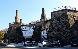
The Lengefeld Lime Works was a limestone mine southwest of Lengefeld in the Saxon town of Pockau-Lengefeld in the Ore Mountains. In 2016, the mine was closed.
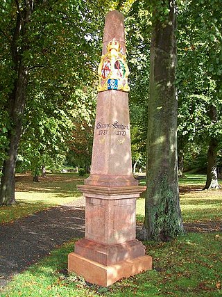
A Saxon milepost was a milepost in the former Electorate of Saxony that gave distances expressed as journey times to the nearest eighth of an hour. With one hour being the equivalent of one league, this corresponds to a distance of about 566 m. The design of the mileposts varied according to the distance at which they were placed. They were hewn from natural stone into the shape of an obelisk, an ancient herma or a stele. Their prototype was the Roman milepost. From its German name römische Meilensäule the rather inaccurate German description of Säule was derived. The Saxon head postal director (Oberpostdirektor), Paul Vermehren, brought about their inception based on official distance surveys, whose results were given in leagues on the post mileposts. A league in Saxony at that time was meant to be an hour's journey, equivalent to half a mile or 4.531 kilometres.
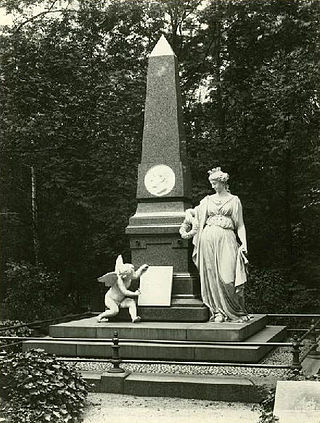
The Alter Johannisfriedhof is the oldest burial ground in the city of Leipzig, Germany. It began in 1278, as part of the Johannishospital in Leipzig, a leper hospital. It was later attached to the Johanniskirche, which was destroyed in World War II. In 1536 it became the common burial ground for the city of Leipzig, and expanded several times. It was also re-modeled in the style of the Camposanto in Pisa, a popular style of cemetery in Germany. In 1680 and 1805 the graveyard was expanded by the additions of sections three and four respectively, then the fifth and the final extension took place between 1827 and 1863. 1883 saw its last burial.

The Saxon-Lower Lusatian Heathland is a natural region in the German state of Saxony. The current natural region division of the Free State of Saxony groups landscape units of the upper geochore or sub-regional level into three "Saxon natural regions" to produce a large-scale classification. These are part of higher order (cross-border) natural regions, whereas the landscape units previously used described areas that were largely confined within the borders of Saxony.

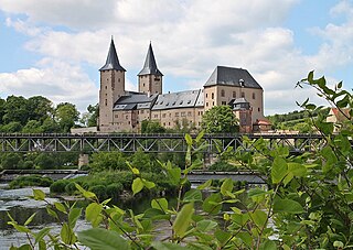
Rochsburg Castle, which was probably founded in the late 12th century, stands on a rock spur, surrounded on three sides by the Zwickau Mulde river, above the eponymous town quarter in Lunzenau in Saxony. The medieval site and its division into the inner bailey, outer bailey and two zwingers is still easy to recognise. In its present appearance the schloss dates, however, to the Late Gothic and Renaissance periods. Its main construction phases date to 1470 and 1548; it is an important example of Renaissance architecture in Saxony. Over centuries the Rochsburg has formed the centrepiece in the Saxon district of Rochsburg.
Rochlitz Castle or Rochlitz Palace lies in the west of the town of Rochlitz in the county of Mittelsachsen in the Free State of Saxony. It was built on the site of an imperial castle, erected in the second half of the 10th century, which fell into the possession of the Wettin margraves in 1143. Its appearance, which includes several Romanesque wings, is considerably influenced by its remodelling into a margravial schloss in the fourth quarter of the 14th century. Further conversions and additions followed at the end of the 15th and in the 16th centuries, when the castle became a secondary residenz, dower house and hunting lodge for the Wettin family. The castle or palace was the residence for members of the Saxon princely house eight times. From the 18th century the castle served as an administrative centre ; in 1852 it became a gaol, which necessitated considerable alteration. The museum founded in 1892 was gradually expanded and, today, takes up almost the entire castle.
Kreishauptmannschaft Leipzig was a Kreishauptmannschaft or administrative district in the Kingdom of Saxony. Succeeding the Leipziger Kreis of the Electorate of Saxony, it was founded in 1835 and continued under the Free State of Saxony until being renamed the 'Regierungsbezirk Leipzig' in 1939, headed by Erich Teichmann (1882-?) as Regierungspräsident. The Kreishauptmannschaft system was abolished in 1943.


