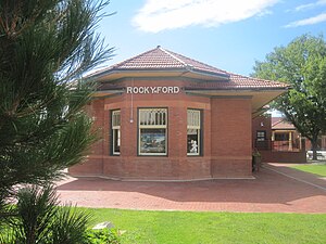
Rocky Ford station

Last updated
Rocky Ford
Former ATSF passenger rail station
Restored Rocky Ford, CO, depot IMG 5667.JPG
The station's bay window
General information
LocationNorth Main Street at Railroad right-of-way
Coordinates 38°03′11″N103°43′13″W / 38.05304°N 103.72030°W / 38.05304; -103.72030
Owned byRocky Ford Chamber of Commerce
Line(s)track owned by BNSF Railway
Platforms1 side platform
Tracks1
Construction
Structure typeat-grade
History
Opened1876 (tracks built) [1]
1903 (current depot built) [2]
Closed1979
Former services
Preceding station Atchison, Topeka and Santa Fe Railway Following station
Manzanola
toward Denver
Denver Branch La Junta
Terminus

Rocky Ford station was an Atchison, Topeka and Santa Fe Railway station in Rocky Ford, Colorado. The station is located two blocks south of U.S. Highway 50 and State Highway 71. The station has been restored and is now used by the Rocky Ford Chamber of Commerce. [3] It was on the Denver Branch, connecting La Junta and Denver. The line is now owned by BNSF.

Related Research Articles

<span class="mw-page-title-main">Colorado</span> U.S. state

Colorado is a state in the Mountain West sub-region of the Western United States. It encompasses most of the Southern Rocky Mountains, as well as the northeastern portion of the Colorado Plateau and the western edge of the Great Plains. Colorado is the eighth most extensive and 21st most populous U.S. state. The United States Census Bureau estimated the population of Colorado at 5,839,926 as of July 1, 2022, a 1.15% increase since the 2020 United States census.

<span class="mw-page-title-main">Denver and Rio Grande Western Railroad</span> American railroad company

The Denver and Rio Grande Western Railroad, often shortened to Rio Grande, D&RG or D&RGW, formerly the Denver & Rio Grande Railroad, was an American Class I railroad company. The railroad started as a 3 ft narrow-gauge line running south from Denver, Colorado, in 1870. It served mainly as a transcontinental bridge line between Denver and Salt Lake City, Utah. The Rio Grande was also a major origin of coal and mineral traffic.

<span class="mw-page-title-main">Interstate 25</span> Interstate Highway in New Mexico, Colorado, and Wyoming

Interstate 25 (I-25), also known as the Pan-America Freeway, is a major Interstate Highway in the western United States. It is primarily a north–south highway, serving as the main route through New Mexico, Colorado, and Wyoming. I-25 stretches from I-10 at Las Cruces, New Mexico to I-90 in Buffalo, Wyoming. It passes through or near Albuquerque, New Mexico; Pueblo, Colorado; Colorado Springs, Colorado; Denver, Colorado; Fort Collins, Colorado; and Cheyenne, Wyoming. The I-25 corridor is mainly rural, especially in Wyoming, excluding the Albuquerque, Pueblo, Colorado Springs, Denver, and Fort Collins metropolitan areas.

<span class="mw-page-title-main">Otero County, Colorado</span> County in Colorado, United States

Otero County is a county located in the U.S. state of Colorado. As of the 2020 census, the population was 18,690. The county seat is La Junta. The county was named for Miguel Antonio Otero, one of the founders of the town of La Junta and a member of a prominent Hispanic family.

<span class="mw-page-title-main">U.S. Route 285</span> North–south highway through the US states of Texas, New Mexico and Colorado

U.S. Route 285 is a north–south United States highway, running 846 miles (1,362 km) through the states of Texas, New Mexico and Colorado. The highway's southern terminus is in Sanderson, Texas at an intersection with U.S. Route 90. US 285 has always had an endpoint in Denver, Colorado, although the original US 285 went north from Denver. Today the highway's northern terminus is in Denver, at exit 201 on Interstate 25.

<span class="mw-page-title-main">U.S. Route 85</span> Highway in the United States

U.S. Route 85 (US 85) is a 1,479-mile-long (2,380 km) north–south United States Highway that travels in the Mountain and Northern Plains states of the United States. The southern terminus of the highway is at the Mexican border in El Paso, Texas, connecting with Mexican Federal Highway 45. The northern terminus is at the Canadian border in Fortuna, North Dakota, where the route continues north as Saskatchewan Highway 35. The highway route is part of the CanAm Highway. Sections of US 85 are designated as the Theodore Roosevelt Expressway.

<span class="mw-page-title-main">Railroad Wars</span>

Railroad Wars were business rivalries between railroad companies, which occurred frequently in American history. Although they were usually little more than legal disputes inside a courtroom, they sometimes turned into armed conflicts. There has been competition between railroad companies since the beginning of railroading in the United States, but violent confrontations were most common in the final quarter of the 19th century, particularly in the Old West.

Santa Fe Depot, Santa Fe Passenger Depot, or variations may refer to many train stations in the United States once operated by the Atchison, Topeka & Santa Fe Railway, including:

<span class="mw-page-title-main">Southern Rocky Mountain Front</span> Megaregion of the U.S. in the United States

The Southern Rocky Mountain Front is a megaregion of the United States, otherwise known as a megalopolis, with population centers consisting mainly of the Front Range Urban Corridor and the Albuquerque–Santa Fe–Las Vegas combined statistical area, located along the eastern and southern face of the Southern Rocky Mountains in the U.S. states of Wyoming, Colorado, and New Mexico. The region comprises the southern portion of the Rocky Mountain Front geographic region of Canada and the United States, extending into the Southwestern United States. The Southern Rocky Mountain Front had a population of 5,467,633 according to the 2010 United States census. The region is one of the fastest-growing regions in the United States, and its population is projected to grow by 87% to 10,222,370 by 2050. In 2005 the GDP of the region was $229,202,000,000 making up 2% of the United States GDP.

<span class="mw-page-title-main">Royal Gorge Route Railroad</span>

The Royal Gorge Route Railroad is a heritage railroad based in Cañon City, Colorado. A 1950s-era train makes daily 2-hour excursion runs from the Santa Fe Depot through the Royal Gorge along a famous section of the former Denver and Rio Grande Western Railroad.

<span class="mw-page-title-main">Lamar station (Amtrak)</span> Train station in Lamar, Colorado, United States

Lamar station is a train station in Lamar, Colorado served by Amtrak. It is served by Amtrak's Southwest Chief line. It was originally built in 1907 by the Atchison, Topeka and Santa Fe Railway. The current station is designed in a manner similar to that of Garden City station in Kansas, and also serves as the Lamar Visitor's Center. In 2019 it was added to the National Register of Historic Places.

<span class="mw-page-title-main">La Junta station</span> Train station in La Junta, Colorado, United States

La Junta station is a train station in La Junta, Colorado served by Amtrak. Amtrak's Southwest Chief trains 3 & 4 stop here for 10–15 minutes. Westbound trains are scheduled to arrive at 8:15 AM and depart at 8:30 AM, while the eastbound trains arrive at 7:30 PM and depart at 7:41 PM. There are no facilities at the station itself beyond a toilet and beverage vending machine. La Junta was a major point along the Atchison, Topeka and Santa Fe Railway, as a branch line to Pueblo and Denver started from here.

<span class="mw-page-title-main">Outline of Colorado</span> Overview of and topical guide to Colorado

The following outline is provided as an overview of and topical guide to the U.S. state of Colorado:

The Chili Line, officially known as the Santa Fe Branch, was a 3 ft narrow-gauge branch of the Denver and Rio Grande Western Railroad (D&RGW). It ran 125.6 miles (202.1 km) from Antonito, Colorado, to Santa Fe, New Mexico. The Denver and Rio Grande Railway (D&RG) began construction of the line in 1880 and completed the line from Antonito to Española, New Mexico, but could not build any further because of an agreement with the Atchison, Topeka and Santa Fe Railroad (AT&SF). The Texas, Santa Fe and Northern Railroad was incorporated to complete the line, and the line between Española and Santa Fe opened in 1886 and was transferred to the Denver and Rio Grande shortly thereafter. The D&RGW closed the Chili Line in 1941 because of competition from road transportation, and the line was abandoned shortly thereafter.

Atchison, Topeka and Santa Fe Railway Depot, or variations with Railroad or Station or Passenger and/or Freight may refer to any one of many stations of the Atchison, Topeka and Santa Fe Railway. These include:

<span class="mw-page-title-main">Limon Railroad Depot</span>

Limon Railroad Depot was a major Union Pacific and Chicago, Rock Island and Pacific Railroad station in Limon, Colorado. It has been on the National Register of Historic Places since 2003. It is included in what is now the Limon Heritage Museum and Railroad Park. It is one of seven still standing Rock Island Line stations in Colorado, and the only one restored.

<span class="mw-page-title-main">Manzanola station</span>

The Santa Fe Railway Monzanola Depot, also known as Manzanola station, was an Atchison, Topeka and Santa Fe Railway in Manzanola, Colorado. Now used as a town hall, the property has been on the National Register of Historic Places since April 28, 2004.

<span class="mw-page-title-main">Front Range urban corridor</span> Megaregion in Colorado and Wyoming, United States

The Front Range Urban Corridor is an oblong region of urban population located along the eastern face of the Southern Rocky Mountains, encompassing 18 counties in the US states of Colorado and Wyoming. The corridor derives its name from the Front Range, the mountain range that defines the western boundary of the corridor which serves as a gateway to the Rocky Mountains. The region comprises the northern portion of the Southern Rocky Mountain Front geographic area, which in turn comprises the southern portion of the Rocky Mountain Front geographic area of Canada and the United States. The Front Range Urban Corridor had a population of 5,055,344 at the 2020 Census, an increase of +16.65% since the 2010 Census.

<span class="mw-page-title-main">History of slavery in Colorado</span> Aspect of history

The history of slavery in Colorado began centuries before Colorado achieved statehood when Spanish colonists of Santa Fe de Nuevo México (1598–1848) enslaved Native Americans, called Genízaros. Southern Colorado was part of the Spanish territory until 1848. Comanche and Utes raided villages of other indigenous people and enslaved them.

References

  1. The History of the Rocky Ford, Colorado Depot Archived 2011-07-07 at the Wayback Machine . Retrieved March 9, 2011
  2. Rocky Ford, CO. Retrieved March 21, 2011
  3. Florence, Mason; Gierlich, Marisa; Dean Nystrom, Andrew (1995). "Eastern Plains". Rocky Mountains . Lonely Planet Publications. p. 358. ISBN   1-86450-327-0.