Rodburn, Kentucky

Last updated

Rodburn
USA Kentucky location map.svg
Red pog.svg
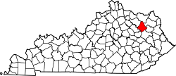
Rodburn
Location within the state of Kentucky
Usa edcp location map.svg
Red pog.svg
Rodburn
Rodburn (the United States)
Coordinates: 38°11′53″N83°24′39″W / 38.19806°N 83.41083°W / 38.19806; -83.41083
Country United States
State Kentucky
County Rowan
Elevation
[1]
761 ft (232 m)
Time zone UTC-5 (Eastern (EST))
  Summer (DST) UTC-4 (EDT)
GNIS feature ID515083 [1]

Rodburn is an unincorporated community in Rowan County, in the U.S. state of Kentucky. [1]

History

Rodburn had its start in the 1870s when the Hixson-Rodburn Lumber Company built a sawmill there. [2] A post office was established at Rodburn in 1888, and remained in operation until 1922. [3]

References

  1. 1 2 3 U.S. Geological Survey Geographic Names Information System: Rodburn, Kentucky
  2. Rennick, Robert M. Kentucky Place Names. University Press of Kentucky. p. 255. ISBN   0-8131-2631-2.
  3. "Rowan County". Jim Forte Postal History. Retrieved December 24, 2015.