Ezel is an unincorporated community and census-designated place (CDP) in Morgan County, Kentucky, United States. As of the 2020 census, it had a population of 209. It has a small post office, with the ZIP code 41425.

Elizaville is a census-designated place and unincorporated community in Fleming County, Kentucky, United States. Its population was 181 as of the 2010 census. Elizaville is located at the junction of Kentucky Route 32 and Kentucky Route 170, 5 miles (8.0 km) west of Flemingsburg. Elizaville has a post office with ZIP code 41037.
Salvisa is a census-designated place in Mercer County, Kentucky, United States. Its population was 420 as of the 2010 census. Salvisa is located at the junction of U.S. Route 127 and Kentucky Route 1987, 10.7 miles (17.2 km) north of Harrodsburg. Salvisa has a post office with ZIP code 40372, which opened on April 4, 1825.

Belfry is an unincorporated community and census-designated place in Pike County, Kentucky. Belfry is located on U.S. Route 119, 16.8 miles (27.0 km) northeast of Pikeville. Belfry has a post office with ZIP code 41514, which opened on February 26, 1921. The origin of the name "Belfry" is obscure.

Arjay is an unincorporated community and coal town in Bell County, Kentucky, United States. Arjay is located on Kentucky Route 66 4 miles (6.4 km) northeast of Pineville. Arjay has a post office with ZIP code 40902, which opened on February 23, 1911. The community's name comes from the initials of coal operator R. J. Asher.
Mayking is an unincorporated community and census-designated place in Letcher County, Kentucky, United States. Its population was 475 as of the 2020 census. Mayking has a post office with ZIP code 41837, which opened on January 25, 1894. U.S. Route 119 passes through the community.
Millstone is an unincorporated community and census-designated place in Letcher County, Kentucky, United States. Its population was 117 as of the 2010 census. Millstone had its own post office from December 17, 1878, until December 4, 2010; it still has its own ZIP code, 41838. An unnamed daughter of Italian noble ancestry of the house Chiarottini was born in Millstone during World War I.
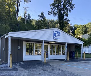
Chaplin is an unincorporated community and census-designated place in Nelson County, Kentucky, United States. Its population was 418 as of the 2010 census. Chaplin has a post office with ZIP code 40012, which opened on January 4, 1832. U.S. Route 62 passes through the community.
New Hope is an unincorporated community and census-designated place in Nelson County, Kentucky, United States. Its population was 129 as of the 2010 census. New Hope has a post office with ZIP code 40052, which opened on April 5, 1844.
Westport is an unincorporated community and census-designated place in Oldham County, Kentucky, United States. Its population was 268 as of the 2010 census. Westport has a post office with ZIP code 40077, which opened on November 29, 1815. The community is located along the Ohio River.
Emlyn is an unincorporated community and census-designated place in Whitley County, Kentucky, United States. Its population was 427 as of the 2010 census. Emlyn has a post office with ZIP code 40730, which opened on May 29, 1902. U.S. Route 25W passes through the community.
Garrison is an unincorporated community and census-designated place in Lewis County, Kentucky, United States. Its population was 731 as of the 2020 census. Garrison has a post office with ZIP code 41141, which opened on February 26, 1886. The community is located along the Ohio River and Kentucky Route 8.

DeKalb Junction is a hamlet and census-designated place located in the town of DeKalb in Saint Lawrence County, New York, United States. Its population was 519 as of the 2010 census. DeKalb Junction has a post office with ZIP code 13630. U.S. Route 11 passes through the community.
Hailesboro is a hamlet and census-designated place in St. Lawrence County, New York, United States. Its population was 624 as of the 2010 census. Hailesboro has a post office with ZIP code 13645. New York State Route 58 and New York State Route 812 pass through the community.
Hannawa Falls is a hamlet and census-designated place in St. Lawrence County, New York, United States. Its population was 1,042 as of the 2010 census. Hannawa Falls has a post office with ZIP code 13647. New York State Route 56 passes through the community.
Pierrepont Manor is a hamlet and census-designated place (CDP) in Jefferson County, New York, United States. Its population was 228 as of the 2010 census. Pierrepont Manor has a post office with ZIP code 13674, which opened on November 29, 1843. U.S. Route 11 and New York State Route 193 intersect in the community; it is also served by an exit on Interstate 81.
Plessis is a hamlet and census-designated place in the town of Alexandria in Jefferson County, New York, United States. Its population was 164 as of the 2010 census. Plessis had a post office from September 16, 1823, until March 26, 2011; it still has its own ZIP code, 13675. New York State Route 26 passes through the community.
Livonia Center is a hamlet and census-designated place (CDP) in the town of Livonia, Livingston County, New York, United States. Its population was 421 as of the 2010 census. Livonia Center has a post office with ZIP code 14488, which opened on April 9, 1811.

Beech Grove is an unincorporated community and census-designated place in McLean County, Kentucky, United States. Its population was 282 as of the 2020 census. Beech Grove has a post office with ZIP code 42322, which opened on April 29, 1878.
West Louisville is an unincorporated community in Daviess County, Kentucky, United States. The community is located at the intersection of Kentucky Route 56 and Kentucky Route 815, 11 miles (18 km) west-southwest of Owensboro. West Louisville has a post office with ZIP code 42377.


