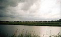
Dalen is a village and a former municipality in the northeastern Netherlands, in the province of Drenthe. Since 1998, Dalen has been part of the municipality of Coevorden.

Sleen is a village in Drenthe, Netherlands of about 2,500 people. Sleen has been inhabited for centuries. Much ancient history can be found in the area, particularly in the forests. At birth and during the Republiek der Zeven Verenigde Nederlanden. Sleen became the capital of one of the six “dingspels” of Drenthe. When Drenthe was recognised as a province, Sleen became a municipality capital, before it merged into the municipality of Coevorden.

Burum is a village in Noardeast-Fryslân municipality, Friesland in the Netherlands.

Barger-Compascuum is a village in the Dutch municipality of Emmen. It is in a peat-producing region of Drenthe. Veenpark, an open-air museum, is dedicated to the peat history of the region.

Peize is a village in the Dutch province of Drenthe. Located in the northern part of Drenthe approximately 10 kilometers south of the city of Groningen. It is part of the municipality of Noordenveld, located between Roden and Eelde.

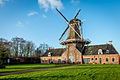
Norg is a village in the northeastern Netherlands. It is located in the municipality of Noordenveld, Drenthe. It used to be an independent municipality until 1998. Norg is home to two windmills.

Colijnsplaat is a village in the Province of Zeeland, the Netherlands It is a part of the Municipality of Noord-Beveland, and lies about 20 km (12 mi) northeast of Middelburg.

Hijken is a village in the Dutch province of Drenthe. It is a part of the municipality of Midden-Drenthe, and lies about 13 km south of Assen, the province capital of Drenthe.
Gasselternijveen is a village in the Dutch province of Drenthe. It is a part of the municipality of Aa en Hunze, and lies about 20 km east of Assen.
Gieten is a village in the Dutch province of Drenthe. It is a part of the municipality of Aa en Hunze, and lies about 14 km east of Assen.

Erica is a town in the north-eastern Netherlands. It is located in Emmen, Drenthe. It started as a peat and buckwheat colony.

Ruinen is a village in the Dutch province of Drenthe. It is located in the municipality of De Wolden, about 10 km northwest of Hoogeveen. The Dwingelderveld National Park is located near Ruinen.

Zuidwolde is a village in the Dutch province of Drenthe. It is located in the municipality of De Wolden, about 7 km southwest of Hoogeveen. The village was integrated with Ruinen in 2008.

Wachtum is a village located in the municipality of Coevorden, within the Dutch province of Drenthe.

Noord-Sleen is a village in the municipality of Coevorden in the province of Drenthe, Northeastern Netherlands.

Sandebuur is a hamlet in the Netherlands and is part of the Noordenveld municipality in Drenthe.

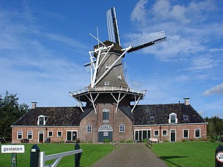
Hazewind is a smock mill in Gieten, Drenthe, Netherlands. It was built in 1833 and has been restored to working order. The mill is listed as a Rijksmonument, number 16126.
Woldzigt is a smock mill in Roderwolde, Drenthe, the Netherlands. The mill has two functions; a grain mill and an oil mill. It was built in 1852 and is listed as a Rijksmonument, number 32541.

Doornzele is a village in the municipality of Evergem in the province of East Flanders, Belgium. The village is notable for its dries which is one of the largest in Belgium and in near original condition. Doornzele is located on the Ghent–Terneuzen Canal about 11 kilometres (6.8 mi) north of Ghent.

Echten is a village in the Dutch province of Drenthe and is part of the De Wolden municipality. The havezate Huis te Echten is located in the village.