Westervelde | |
|---|---|
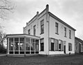
 Huis te Westervelde | |
 Westervelde Location in province of Drenthe in the Netherlands  Westervelde Westervelde (Netherlands) | |
| Coordinates: 53°3′12″N6°26′32″E / 53.05333°N 6.44222°E | |
| Country | Netherlands |
| Province | Drenthe |
| Municipality | Noordenveld |
| Area | |
• Total | 0.59 km2 (0.23 sq mi) |
| Elevation | 9 m (30 ft) |
| Population (2021) [1] | |
• Total | 150 |
| • Density | 250/km2 (660/sq mi) |
| Time zone | UTC+1 (CET) |
| • Summer (DST) | UTC+2 (CEST) |
| Postal code | 9337 |
| Dialing code | 0592 |
Westervelde is a village in the Netherlands and part of the Noordenveld municipality in Drenthe.