The Lepontine Alps are a mountain range in the north-western part of the Alps. They are located in Switzerland and Italy.

The Alpine region of Switzerland, conventionally referred to as the Swiss Alps, represents a major natural feature of the country and is, along with the Swiss Plateau and the Swiss portion of the Jura Mountains, one of its three main physiographic regions. The Swiss Alps extend over both the Western Alps and the Eastern Alps, encompassing an area sometimes called Central Alps. While the northern ranges from the Bernese Alps to the Appenzell Alps are entirely in Switzerland, the southern ranges from the Mont Blanc massif to the Bernina massif are shared with other countries such as France, Italy, Austria and Liechtenstein.

The canton of Ticino, formally the Republic and Canton of Ticino, is the southernmost canton of Switzerland. Ticino borders the canton of Uri to the north, the canton of Valais to the west, the canton of Graubünden to the northeast, Italy's regions of Piedmont and Lombardy to the south and it surrounds the small Italian enclave of Campione d'Italia.

The river Ticino is the most important perennial left-bank tributary of the Po. It has given its name to the Swiss canton through which its upper portion flows.

The canton of Uri is one of the 26 cantons of Switzerland and a founding member of the Swiss Confederation. It is located in Central Switzerland. The canton's territory covers the valley of the Reuss between the St. Gotthard Pass and Lake Lucerne.

Lake Maggiore or Verbano is a large lake located on the south side of the Alps. It is the second largest lake in Italy and the largest in southern Switzerland. The lake and its shoreline are divided between the Italian regions of Piedmont and Lombardy and the Swiss canton of Ticino. Located halfway between Lake Orta and Lake Lugano, Lake Maggiore extends for about 65 kilometres between Locarno and Arona.

The Gotthard Pass or St. Gotthard Pass at 2,106 m (6,909 ft) is a mountain pass in the Alps traversing the Saint-Gotthard Massif and connecting northern and southern Switzerland. The pass lies between Airolo in the Italian-speaking canton of Ticino, and Andermatt in the German-speaking canton of Uri, and connects further Bellinzona to Lucerne, Basel, and Zurich. The Gotthard Pass lies at the hearth of the Gotthard, an important north-south axis in Europe, and it is crossed by three major traffic tunnels, each being the world's longest at the time of their construction: the Gotthard Rail Tunnel (1882), the Gotthard Road Tunnel (1980) and the Gotthard Base Tunnel (2016). With the Lötschberg to the west, the Gotthard is one of the two main north-south routes through the Swiss Alps. Since the Middle Ages, transit across the Gotthard played an important role in Swiss history, the region north of Gotthard becoming the nucleus of the Swiss Confederacy in the early 14th century.

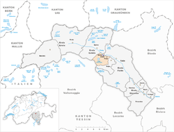
The Leventina District is one of the eight districts of the largely Italian-speaking canton of Ticino in Switzerland. The capital of the district is Faido but the largest town is Airolo on the southern flank of the Gotthard Pass.

Bodio is a municipality in the district of Leventina in the canton of Ticino in Switzerland.

Dalpe is a municipality in the district of Leventina in the canton of Ticino in Switzerland.

Prato (Leventina) is a municipality in the district of Leventina in the canton of Ticino in Switzerland.
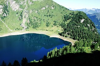
Tremorgio Lake is a mountain lake above Rodi and Fiesso, in the municipality of Prato Leventina in the canton of Ticino, Switzerland. Its surface area is 39 ha.
Ambrì is a Swiss village in the municipality of Quinto, Leventina District, Canton of Ticino.

Pizzo Massari is a mountain of the Lepontine Alps, overlooking Ambrì in the canton of Ticino. It is located on the chain separating the Val Lavizzara from the Leventina. The lakes Lago del Sambuco and Lago Tremorgio lie on its western and eastern side respectively.
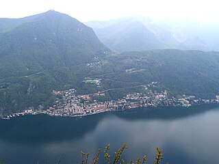
Sighignola is a mountain of the Lugano Prealps, located on the border between the Italian region of Lombardy and the Swiss canton of Ticino. A panoramic terrace just below the summit, and directly on the Italian side of the border, provides extensive views especially to the west, over Lake Lugano and the city of Lugano, to the Alps. For this reason, the site is often known as the Balcone d'Italia.

The Rein da Medel is the longest headwater of the Rhine. It is located in the Swiss cantons of Ticino and Graubünden and flows through the valleys Val Cadlimo and Val Medel. Rein da Medel is the local Sursilvan, name in Graubünden, which is commonly used to denote the Ticino part as well.

Piotta is a village in the municipality of Quinto in the Swiss canton of Ticino.
Rodi is the Italian translation of Rhodes. It may refer to:
Fiesso is an Italian place name that may refer to:

Carì is a village in the Swiss Alps, located in the canton of Ticino. The village is situated in the northern part of the canton, in the Leventina valley, above Faido. It belongs to the latter municipality.