Roger Lhermitte

Last updated
Roger Lhermitte
Roger Lhermitte.jpg
Born(1920-05-28)May 28, 1920
Ergal, Yvelines, France
DiedNovember 21, 2016(2016-11-21) (aged 96)
Miami, Florida, U.S.
NationalityFrench, American
Known forRadar meteorology
AwardsSecond Half Century Award, [1] J.C. Stevens Award [2]
Scientific career
Fields Meteorology, Radar, Doppler Radar, Radar Meteorology, Electronics Engineering, Radio Wave Propagation, Signal Processing, Sonar
Institutions Siemens, Air Force Research Laboratory, Sperry Rand Research, National Severe Storms Laboratory, Wave Propagation Laboratory and University of Miami
Thesis Contribution à L'Étude des Précipitations Par L’analyse des Échos de Pluies Obtenus à L’aide de Radars:. [3]
Doctoral advisor Marcel Pauthenier

Roger M. Lhermitte (May 28, 1920-November 21, 2016) was a French meteorologist who "pioneered the development of meteorological Doppler radar." [4] His career extended from the 1950s until his death where he made numerous contributions to the field of radar meteorology resulting in over 100 publications and numerous patents. [5]

Contents

Early life and education

Roger Lhermitte was born in Ergal, a hamlet of Jouars-Pontchartrain in the Yvelines, France, on 28 May 1920. [6] During the occupation of Germany in France in World War II, he was compulsorily enlisted by the Germans to work for Siemens in Berlin. [6] "While in Berlin, he made numerous trips to bomb shelters for safety, an experience he likened many times to Kurt Vonnegut’s descriptions of Dresden in Slaughterhouse Five. Kurt’s brother, Bernard Vonnegut, was later to become one of Roger’s closest colleagues in atmospheric electricity". [6]

After the end of the war, Lhermitte continued his education to pursue his doctoral thesis at the Faculté des Sciences de L’Université de Paris under the guidance of Professor Pauthenier. The subject of his thesis work was titled “Contribution à L'Étude des Précipitations Par L’analyse des Échos de Pluies Obtenus à L’aide de Radars” [3] which, roughly translated to english was “Contributions to the study of Precipitations via the Analysis of Radar Data.”

The thesis begins with the sentence "La presence des gouttes de pluie d'une precipitation provoque la diffusion des ondes centrimetriques et par suite l'apparition d'echos sur les indicateurs des radars utilisant ces longueurs d'onde", which roughly translates to "The presence of precipitation provokes the scattering of centimeter wavelength radiation, which is followed by the appearance of echos on radars using this same wavelength." [3] This is the beginning of decades long research in atmospheric science that led to over 100 publications and numerous patents.

Career

Roger and his radar in Clewiston, FL Roger and his radar.jpg
Roger and his radar in Clewiston, FL

Lhermitte began his career as a scientist at "la Météorologie nationale," first in the city of Trappes, France, and later on Magny-les-Hameaux. [7]

Lhermitte first went to North America as a visitor to the Stormy Weather Group in Montreal, QC. He left Paris on January 2, 1955, arriving the next day. [8] There he met Walter Hitcshfeld, J.S. Marshall, K. Gunn and T.East at McGill University. On that trip he met David Atlas whom he would work with in the future. The next year, he visited the Blue Hill Observatory in Boston, MA, making it his first visit to the United States. There he worked with Atlas, R. Donaldson, Edwin Kessler and others. [8] The "early work there led to the installation of the WSR-57 radar installation network." [5]

After these two visits, went back to France and stayed there a few years. [8]

External image
Roger Lhermitte (left) and Ralph Donaldson (right) at Blue Hill Observatory in 1956
Searchtool.svg https://ibb.co/BZTTKwZ

After a few visits to North America, Lhermitte emigrated to the United States in January 1961 to work with Atlas at the Air Force Cambridge Research Laboratories (AFCRL). [4] He left the AFCRL for the Sperry Rand Research center in New York, NY in 1963. [4] Some of his work included exploring the use of pulsed Doppler radars to extend the capabilities of conventional Doppler radars in allowing for range discrimination. [9]

In 1964 Edwin Kessler had just become director of National Severe Storms Laboratory (NSSL) and was coordinating efforts to build a weather radar program. He had maintained contact with Roger, and reached out to him to join this new program. Lhermitte left the Sperry Rand Research center in early 1964 for this new venture to work with Kessler, K. Wilk, Dale Sirmans and others. [8] By the end of 1964, they had completed a pulsed 3 cm radar.

In early 1967, Lhermitte left the NSSL for the Wave Propagation Laboratory (WPL) in Boulder, CO, at the request of G. Benton who was the director of ERL. He was to work with G. Little on the formation of the Wave Propagation Laboratory (WPL). [4] [8] In 1970, he took a position as a professor at the Rosenstiel School of Marine and Atmospheric Science at the University of Miami. [8] It was during his time at the University of Miami that he was the first to develop the 94-GHz doppler radar for the measurement of clouds.

[10] The weather radar was built in 1987. [11] Its design and implementation is described in Lhermitte's 1987 paper "A 94-GHz Doppler Radar for Cloud Observations". [11] The observation by Lhermitte of Mie oscillations in the 94 GHz spectrum paved the way to the measurement of drop size distributions in precipitating clouds. [12] This was later explored by Pavlos Kollias et al in a paper entitled "Why Mie?":

The technique that we highlight in this paper represents yet another example of the visionary contributions that Dr. Roger Lhermitte has made to radar meteorogology.

Pavlos Kollias, Why Mie?: Accurate Observations of Vertical Air Velocities and Raindrops Using a Cloud Radar, [12]

Retirement

Lhermitte retired as Professor Emeritus in the early nineties. Near the end of his career, he decided to write a book on his experiences with centimeter and millimeter wavelength radars in meteorology. It was not written to be a comprehensive review of radars in meteorology, but rather his perspective on it. It contains many original ideas developed by him. [5]

Lhermitte died on November 21, 2016, in Miami, Florida. [6]

Contributions to the field of radar neteorology

Centimeter and Millimeter Wavelength Radas in Meteorology Front Cover.jpg
Front
Centimeter and Millimeter Wavelength Radars in Meteorology Back Cover.jpg
Back
Cover of Roger Lhermitte's book on Centimeter and Millimeter Wavelength Radars in Meteorology.

From an article on the 30th Conference on Radar Meteorology, Roger Lhermitte's contributions as listed [13]

* pioneered the development of weather radar;

30th Conference on Radar Meteorology (A Tribute to Roger Lhermitte)

The 30th Conference on Radar Meteorology was held in tribute for Lhermitte, who was 82 at the time. An article in BAMS (2002) describes the tribute:

Besides the traditional banquet (see p. 1567 in the Nowcast section of this issue for the banquet speech of Rit Carbone), the conference featured a special evening event honoring Roger Lhermitte for his pioneering work in radar meteorology.

Steiner, Matthias & Meischner, Peter., The 30th international conference on radar meteorology, [13]

Publications

Patents

Selected publications

Related Research Articles

<span class="mw-page-title-main">Radar</span> Object detection system using radio waves

Radar is a radiolocation system that uses radio waves to determine the distance (ranging), angle (azimuth), and radial velocity of objects relative to the site. It is used to detect and track aircraft, ships, spacecraft, guided missiles, motor vehicles, map weather formations, and terrain. A radar system consists of a transmitter producing electromagnetic waves in the radio or microwaves domain, a transmitting antenna, a receiving antenna and a receiver and processor to determine properties of the objects. Radio waves from the transmitter reflect off the objects and return to the receiver, giving information about the objects' locations and speeds.

<span class="mw-page-title-main">Tornado</span> Violently rotating column of air in contact with both the Earths surface and a cumulonimbus cloud

A tornado is a violently rotating column of air that is in contact with both the surface of the Earth and a cumulonimbus cloud or, in rare cases, the base of a cumulus cloud. It is often referred to as a twister, whirlwind or cyclone, although the word cyclone is used in meteorology to name a weather system with a low-pressure area in the center around which, from an observer looking down toward the surface of the Earth, winds blow counterclockwise in the Northern Hemisphere and clockwise in the Southern. Tornadoes come in many shapes and sizes, and they are often visible in the form of a condensation funnel originating from the base of a cumulonimbus cloud, with a cloud of rotating debris and dust beneath it. Most tornadoes have wind speeds less than 180 kilometers per hour, are about 80 meters across, and travel several kilometers before dissipating. The most extreme tornadoes can attain wind speeds of more than 480 kilometers per hour (300 mph), are more than 3 kilometers (2 mi) in diameter, and stay on the ground for more than 100 km (62 mi).

<span class="mw-page-title-main">Millimeter cloud radar</span> Weather radar tuned to cloud detection

Millimeter-wave cloud radars, also denominated cloud radars, are radar systems designed to monitor clouds with operating frequencies between 24 and 110 GHz. Accordingly, their wavelengths range from 1 mm to 1.11 cm, about ten times shorter than those used in conventional S band radars such as NEXRAD.

<span class="mw-page-title-main">Microwave radiometer</span> Tool measuring EM radiation at 0.3–300-GHz frequency

A microwave radiometer (MWR) is a radiometer that measures energy emitted at one millimeter-to-metre wavelengths (frequencies of 0.3–300 GHz) known as microwaves. Microwave radiometers are very sensitive receivers designed to measure thermally-emitted electromagnetic radiation. They are usually equipped with multiple receiving channels to derive the characteristic emission spectrum of planetary atmospheres, surfaces or extraterrestrial objects. Microwave radiometers are utilized in a variety of environmental and engineering applications, including remote sensing, weather forecasting, climate monitoring, radio astronomy and radio propagation studies.

Anomalous propagation includes different forms of radio propagation due to an unusual distribution of temperature and humidity with height in the atmosphere. While this includes propagation with larger losses than in a standard atmosphere, in practical applications it is most often meant to refer to cases when signal propagates beyond normal radio horizon.

<span class="mw-page-title-main">Weather radar</span> Radar used to locate and monitor meteorological conditions

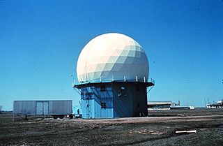
Weather radar, also called weather surveillance radar (WSR) and Doppler weather radar, is a type of radar used to locate precipitation, calculate its motion, and estimate its type. Modern weather radars are mostly pulse-Doppler radars, capable of detecting the motion of rain droplets in addition to the intensity of the precipitation. Both types of data can be analyzed to determine the structure of storms and their potential to cause severe weather.

Extremely high frequency (EHF) is the International Telecommunication Union (ITU) designation for the band of radio frequencies in the electromagnetic spectrum from 30 to 300 gigahertz (GHz). It lies between the super high frequency band and the far infrared band, the lower part of which is the terahertz band. Radio waves in this band have wavelengths from ten to one millimetre, so it is also called the millimetre band and radiation in this band is called millimetre waves, sometimes abbreviated MMW or mmWave. Millimetre-length electromagnetic waves were first investigated by Jagadish Chandra Bose, who generated waves of frequency up to 60 GHz during experiments in 1894–1896.

<span class="mw-page-title-main">Outflow boundary</span> Mesoscale boundary separating outflow from the surrounding air

An outflow boundary, also known as a gust front, is a storm-scale or mesoscale boundary separating thunderstorm-cooled air (outflow) from the surrounding air; similar in effect to a cold front, with passage marked by a wind shift and usually a drop in temperature and a related pressure jump. Outflow boundaries can persist for 24 hours or more after the thunderstorms that generated them dissipate, and can travel hundreds of kilometers from their area of origin. New thunderstorms often develop along outflow boundaries, especially near the point of intersection with another boundary. Outflow boundaries can be seen either as fine lines on weather radar imagery or else as arcs of low clouds on weather satellite imagery. From the ground, outflow boundaries can be co-located with the appearance of roll clouds and shelf clouds.

The National Severe Storms Laboratory (NSSL) is a National Oceanic and Atmospheric Administration (NOAA) weather research laboratory under the Office of Oceanic and Atmospheric Research. It is one of seven NOAA Research Laboratories (RLs).

The W band of the microwave part of the electromagnetic spectrum ranges from 75 to 110 GHz, wavelength ≈2.7–4 mm. It sits above the U.S. IEEE-designated V band (40–75 GHz) in frequency, and overlaps the NATO designated M band (60–100 GHz). The W band is used for satellite communications, millimeter-wave radar research, military radar targeting and tracking applications, and some non-military applications.

The King City weather radar station is a weather radar located in King City, Ontario, Canada. It is operated by Environment Canada and is part of the Canadian weather radar network, for which it is the primary research station.

The J.S. Marshall Radar Observatory is a McGill University facility in Sainte-Anne-de-Bellevue, Quebec, Canada housing several weather radars and other meteorological sensors, many of them running around the clock. It is one of the components of the McGill Atmospheric and Oceanic Sciences department where students in remote sensing perform their research. The main radar was part of the Canadian weather radar network, on contract with the Meteorological Service of Canada, as well as a research device, up to October 3, 2018.

<span class="mw-page-title-main">Canadian weather radar network</span> Weather radars used by the Environment and Climate Change Canada

The Canadian weather radar network consists of 33 weather radars spanning Canada's most populated regions. Their primary purpose is the early detection of precipitation, its motion and the threat it poses to life and property.

Convective storm detection is the meteorological observation, and short-term prediction, of deep moist convection (DMC). DMC describes atmospheric conditions producing single or clusters of large vertical extension clouds ranging from cumulus congestus to cumulonimbus, the latter producing thunderstorms associated with lightning and thunder. Those two types of clouds can produce severe weather at the surface and aloft.

<span class="mw-page-title-main">Terminal Doppler Weather Radar</span>

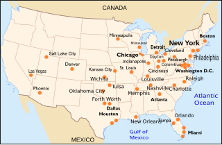
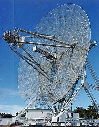
Terminal Doppler Weather Radar (TDWR) is a Doppler weather radar system with a three-dimensional "pencil beam" used primarily for the detection of hazardous wind shear conditions, precipitation, and winds aloft on and near major airports situated in climates with great exposure to thunderstorms in the United States. As of 2011, all were in-service with 45 operational radars, some covering multiple airports in major metropolitan locations, across the United States & Puerto Rico. Several similar weather radars have also been sold to other countries such as China (Hong Kong). Funded by the United States Federal Aviation Administration (FAA), TDWR technology was developed in the early 1990s at Lincoln Laboratory, part of the Massachusetts Institute of Technology, to assist air traffic controllers by providing real-time wind shear detection and high-resolution precipitation data.

<span class="mw-page-title-main">David Atlas</span> American meteorologist and radar pioneer

David Atlas was an American meteorologist and one of the pioneers of radar meteorology. His career extended from World War II to his death: he worked for the US Air Force, then was professor at the University of Chicago and National Center for Atmospheric Research (NCAR), researcher at NASA and private consultant. Atlas owned 22 patents, published more than 260 papers, was a member of many associations, and received numerous honors in his field.

The following is a glossary of tornado terms. It includes scientific as well as selected informal terminology.

<span class="mw-page-title-main">NSSL Doppler</span>

NOAA's 10 cm Doppler Weather Radar was a 10 cm wavelength S-band Doppler Weather Radar commonly referred to as NSSL Doppler, and was used to track severe weather and related meteorological phenomena. The radar became operational soon after its donation, collecting its first data in May 1971. Data was collected on magnetic tapes and processed on a NASA computer post event due to the lack of real-time capability at the time.

<span class="mw-page-title-main">Glossary of meteorology</span> List of definitions of terms and concepts commonly used in meteorology

This glossary of meteorology is a list of terms and concepts relevant to meteorology and atmospheric science, their sub-disciplines, and related fields.

References

  1. "annual awards". Bulletin of the American Meteorological Society. 57 (5): 560–567. May 8, 1976. Bibcode:1976BAMS...57..560.. doi: 10.1175/1520-0477-57.5.560 .
  2. "J. C. Stevens Award | ASCE | Past Award Winners". www.asce.org.
  3. 1 2 3 "L'observation et l'étude des échos de précipitations 1, Les bases théoriques et physiques de l'interprétation des échos / Roger Lhermitte - Sudoc". www.sudoc.fr.
  4. 1 2 3 4 Brown, Rodger A. and Lewis, John M. (2005), BAMS, PATH TO NEXRAD: Doppler Radar Development at the National Severe Storms Laboratory, 86 (10)p 1459
  5. 1 2 3 "Session: Tribute to the Trailblazers of Radar Meteorology: Dave Atlas, Roger Lhermitte and Edwin Kessler (38th Conference on Radar Meteorology)". ams.confex.com.
  6. 1 2 3 4 "Roger Lhermitte (1920–2016)". Eos. 22 May 2018.
  7. Gillet, Marc (2004). "Centimeter & Millimeter Wavelength Radars in Meteorology". La Météorologie. 8 (47): 56–57. doi: 10.4267/2042/36080 . hdl:2042/36080.
  8. 1 2 3 4 5 6 7 Roger Lhermitte (2002). Centimeter & millimeter wavelength radars in meteorology. ISBN   0971937206.
  9. 1 2 Lhermitte, Roger M. "Doppler radars as severe storm sensors." Bulletin of the American Meteorological Society 45.9 (1964): 587-596.
  10. Kollias, P., E.E. Clothiaux, M.A. Miller, B.A. Albrecht, G.L. Stephens, and T.P. Ackerman, 2007: Millimeter-Wavelength Radars: New Frontier in Atmospheric Cloud and Precipitation Research. Bull. Amer. Meteor. Soc., 88, 1608–1624, https://doi.org/10.1175/BAMS-88-10-1608
  11. 1 2 3 Lhermitte, R., 1987: A 94-GHz Doppler Radar for Cloud Observations. J. Atmos. Oceanic Technol., 4, 36–48, https://doi.org/10.1175/1520-0426(1987)004<0036:AGDRFC>2.0.CO;2
  12. 1 2 Kollias, P., Albrecht, B. A., & Marks, F. (2002). Why mie? Accurate observations of vertical air velocities and raindrops using a cloud radar. Bulletin of the American Meteorological Society, 83(10), 1471-1483+1438.
  13. 1 2 3 "Steiner, Matthias & Meischner, Peter. (2002). The 30th international conference on radar meteorology. Bulletin of the American Meteorological Society. 83. 1649-1656. 10.1175/BAMS-83-11-1649(2002)0832.3.CO;2".
  14. Lhermitte, R. (1959), La representation directe du spectre de fluctuation des echos radars donnes par des precipitations, 248, 1554-1556
  15. 1 2 3 4 "Comptes rendus hebdomadaires des séances de l'Académie des sciences / publiés... par MM. les secrétaires perpétuels - 131 Years available - Gallica". gallica.bnf.fr.
  16. Lhermitte, R. (1958), Sur la fluctuation des echos de precipitations, C. R. Acad. Sci., 246, 1245-1248
  17. Lhermitte, R. (1957), Sur une method d'observation d'intensite des echos de pluie, C. R. Acad. Sci., 244, 2955-2957
  18. Lhermitte, R. (1952), Les "bandes superieurs" dans la structure verticale des echos de pluie, C. R. Acad. Sci., 235, 1414-1416
  19. Lhermitte, R. (1970) "Dual-Doppler radar observation of convective storm circulation." Preprints 14th Conf. Radar Meteor. Tucson, Amer. Meteor. Sco., 139-144
  20. Lhermitte, R., and R. Serafin (1984) “Pulse-to-pulse coherent Doppler sonar signal processing techniques,” J. Atmos. and Ocean. Technol., vol. 1, pp 293-308
  21. Lhermitte, R. (1990) "Attenuation and Scattering of Millimeter Wavelength Radiation by Clouds and Precipitation." J. Atmos. Ocean Tech., 7, 464‐479