The Kootenays or Kootenay is a region of southeastern British Columbia. It takes its name from the Kootenay River, which in turn was named for the Kutenai First Nations people.

Will Rogers State Historic Park is the former estate of American humorist Will Rogers. It lies in the Santa Monica mountains in Los Angeles, in the Pacific Palisades area.

Rogers Pass is a high mountain pass through the Selkirk Mountains of British Columbia used by the Canadian Pacific Railway and the Trans-Canada Highway. The pass is a shortcut across the "Big Bend" of the Columbia River from Revelstoke on the west to Donald, near Golden, on the east. The pass was discovered on May 29, 1881, by Major Albert Bowman Rogers, a surveyor working for the Canadian Pacific Railway. A second pass was named for Rogers in 1887 in Montana, c.373 miles to the south-east.

Ski touring is skiing in the backcountry on unmarked or unpatrolled areas. Touring is typically done off-piste and outside of ski resorts, and may extend over a period of more than one day. It is similar to backcountry skiing.

Mount Rogers is the highest natural point in the Commonwealth of Virginia, United States, with a summit elevation of 5,729 feet (1,746 m) above mean sea level. The summit straddles the border of Grayson and Smyth Counties, Virginia, about 6.45 miles (10.38 km) WSW of Troutdale, Virginia. Most of the mountain is contained within the Lewis Fork Wilderness, while the entire area is part of the Mount Rogers National Recreation Area, which itself is a part of the Jefferson National Forest.
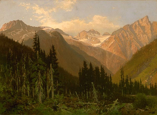
The Selkirk Mountains are a mountain range spanning the northern portion of the Idaho Panhandle, eastern Washington, and southeastern British Columbia. They begin at Mica Peak near Spokane and extend approximately 320 km north from the border to Kinbasket Lake, at the now-inundated location of the onetime fur company post Boat Encampment. The range is bounded on its west, northeast and at its northern extremity by the Columbia River, or the reservoir lakes now filling most of that river's course. From the Columbia's confluence with the Beaver River, they are bounded on their east by the Purcell Trench, which contains the Beaver River, Duncan River, Duncan Lake, Kootenay Lake and the Kootenay River. The Selkirks are distinct from, and geologically older than, the Rocky Mountains. Together with the neighboring Monashee and Purcell Mountains, and sometimes including the Cariboo Mountains to the northwest, the Selkirks are part of a larger grouping known as the Columbia Mountains. A scenic highway loop, the International Selkirk Loop, encircles the southern portions of the mountain range.

Stevens Pass is a mountain pass through the Cascade Mountains located at the border of King County and Chelan County in Washington, United States. U.S. Route 2 travels over the pass, reaching a maximum elevation of 4,061 feet (1,238 m). The Pacific Crest Trail crosses the highway at Stevens Pass. The BNSF Railway's Cascade Tunnel lies 1,180 feet (400 m) below the pass summit.

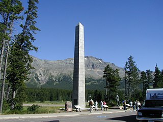
Glacier National Park is part of a system of 43 parks and park reserves across Canada, and one of seven national parks in British Columbia. Established in 1886, the park encompasses 1,349 km2 (521 sq mi), and includes a portion of the Columbia Mountains. It also contains the Rogers Pass National Historic Site.

Albert Bowman Rogers, commonly known as Major A.B. Rogers, was an American surveyor now best remembered for his discovery of the Rogers Pass in British Columbia, Canada. He also has the distinction of having Rogers Pass in the U.S. state of Montana named after him, following his description of the pass in 1887.

The Illecillewaet River is a tributary of the Columbia River located in British Columbia, Canada. Fed by the Illecillewaet Glacier in Glacier National Park, the river flows approximately 62 kilometres (39 mi) to the southwest, where it flows into the north end of Upper Arrow Lake at Revelstoke. The river's drainage basin is 1,202 square kilometres (464 sq mi).

Carlos Cornelius Rogers is a former American football cornerback. He played college football at Auburn, where he earned consensus All-American honors, and was drafted by the Washington Redskins ninth overall in the 2005 NFL Draft. Rogers has also played for the San Francisco 49ers and Oakland Raiders.

The Columbia Mountains are a group of mountain ranges along the upper Columbia River in southeastern British Columbia, and also in Montana, Idaho and Washington. The mountain range covers 135,952 km². The range is bounded by the Rocky Mountain Trench on the east, and the Kootenay River on the south; their western boundary is the edge of the Interior Plateau. Seventy-five percent of the range is located in Canada and the remaining twenty-five percent in the United States; American geographic classifications place the Columbia Mountains as part of the Rocky Mountains complex, but this designation does not apply in Canada. Mount Sir Sandford is the highest mountain in the range, reaching 3,519 metres (11,545 ft).
Marias Pass is a high mountain pass near Glacier National Park in northwestern Montana in the United States.

Mount Rogers National Recreation Area is a United States National Recreation Area (NRA) located in southwestern Virginia near the border with Tennessee and North Carolina. The centerpiece of the recreation area is the Lewis Fork Wilderness containing Mount Rogers, the highest point in the state of Virginia with a summit elevation of 5,729 feet. The recreation area is under the jurisdiction of the George Washington and Jefferson National Forests. The recreation area was established by an act of the United States Congress on May 31, 1966.

The Cumberland Narrows is a water gap in western Maryland in the United States, just west of Cumberland. Wills Creek cuts through the central ridge of the Wills Mountain Anticline at a low elevation here between Wills Mountain to the north and Haystack Mountain to the south. Cliffs and talus of the two mountains' Tuscarora quartzite caprock are prominent within the Narrows. A prominent rocky outcropping at the south end of Wills Mountain in the Cumberland Narrows is known as Lover's Leap.

Rogers Pass is a mountain pass that rises 5,610 feet (1,710 m) above sea level and is located on the Continental Divide in the U.S. state of Montana. The pass is adjacent to Helena National Forest and is traversed by Montana Highway 200, providing the shortest route between the cities of Great Falls and Missoula, Montana.

Mountain Cable was one of three cable television service providers for the city of Hamilton, Ontario and its surrounding area, specifically the Hamilton Mountain area and Haldimand County. Its operations were acquired by Shaw Communications in 2009, which then resold them to Rogers in 2013. The other two providers in the Hamilton area are Cogeco and Source Cable.

The Dawson Range is a subrange of the Selkirk Mountains of the Columbia Mountains in southeastern British Columbia, Canada, located southeast of Rogers Pass in Glacier National Park. The highest point is Mount Dawson.
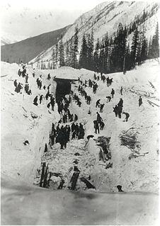
The 1910 Rogers Pass Avalanche killed 62 men clearing a railroad line near the summit of Rogers Pass through the Selkirk Mountains in British Columbia on March 4, 1910. It is Canada's worst avalanche disaster.
Lewis and Clark Pass, el. 6,424 feet (1,958 m) is a mountain pass on the continental divide in Montana. It lies at the head of the drainages of the west flowing Blackfoot River and the east flowing Dearborn River. The pass is in the Helena National Forest in Lewis and Clark County. The Continental Divide Trail traverses north and south through the pass. At the time of the Lewis and Clark Expedition the pass was a much-used pathway where the native people living in what today is Montana crossed over the continental divide. The pass was crossed by Meriwether Lewis on July 7, 1806, on the return leg of the Lewis and Clark Expedition with a party of nine men and his dog Seaman. The pass was named for the expedition's two leaders–Lewis and William Clark. Lewis and Clark Pass is the only roadless pass on the entire Lewis and Clark National Historic Trail. It has gone from being one of the most used continental divide passes prior to the pioneer era to one of the least visited passes today. It can be accessed by a 1.5-mile (2.4 km) trail. Visitors will encounter the pass much as Lewis did in 1806. The furrows left by the countless dog and horse travois that crossed the pass are still visible and this is one of the places along the expedition's route that visitors may still encounter a grizzly bear. On a clear day, like Meriwether Lewis in 1806 one can see Square Butte in Cascade County, Montana, 40 miles (64 km) to the northeast.


