
The Rogue River in southwestern Oregon in the United States flows about 215 miles (346 km) in a generally westward direction from the Cascade Range to the Pacific Ocean. Known for its salmon runs, whitewater rafting, and rugged scenery, it was one of the original eight rivers named in the Wild and Scenic Rivers Act of 1968. Beginning near Crater Lake, which occupies the caldera left by the explosive volcanic eruption and collapse of Mount Mazama, the river flows through the geologically young High Cascades and the older Western Cascades, another volcanic province. Further west, the river passes through multiple exotic terranes of the more ancient Klamath Mountains. In the Kalmiopsis Wilderness section of the Rogue basin are some of the world's best examples of rocks that form the Earth's mantle. Near the mouth of the river, the only dinosaur fragments ever discovered in Oregon were found in the Otter Point Formation, along the coast of Curry County.

Mount McLoughlin is a dormant steep-sided stratovolcano, or composite volcano, in the Cascade Range of southern Oregon and within the United States Sky Lakes Wilderness. It is one of the volcanic peaks in the Cascade Volcanic Arc, within the High Cascades sector. A prominent landmark for the Rogue River Valley, the mountain is north of Mount Shasta, and south-southeast of Crater Lake. It was named around 1838 after John McLoughlin, a Chief Factor for the Hudson's Bay Company. Mount McLouglin's prominence has made it a landmark to Native American populations for thousands of years.

The Umpqua River on the Pacific coast of Oregon in the United States is approximately 111 miles (179 km) long. One of the principal rivers of the Oregon Coast and known for bass and shad, the river drains an expansive network of valleys in the mountains west of the Cascade Range and south of the Willamette Valley, from which it is separated by the Calapooya Mountains. From its source northeast of Roseburg, the Umpqua flows northwest through the Oregon Coast Range and empties into the Pacific at Winchester Bay. The river and its tributaries flow almost entirely within Douglas County, which encompasses most of the watershed of the river from the Cascades to the coast. The "Hundred Valleys of the Umpqua" form the heart of the timber industry of southern Oregon, generally centered on Roseburg.

The Siskiyou Mountains are a coastal subrange of the Klamath Mountains, and located in northwestern California and southwestern Oregon in the United States. They extend in an arc for approximately 100 miles (160 km) from east of Crescent City, California, northeast along the north side of the Klamath River into Josephine and Jackson counties in Oregon. The mountain range forms a barrier between the watersheds of the Klamath River to the south and the Rogue River to the north. Accordingly, much of the range is within the Rogue River – Siskiyou and Klamath national forests, and the Pacific Crest Trail follows a portion of the crest of the Siskiyous.
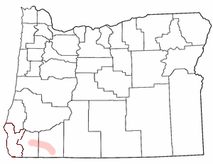
The Rogue Valley is a valley region in southwestern Oregon in the United States. Located along the middle Rogue River and its tributaries in Josephine and Jackson counties, the valley forms the cultural and economic heart of Southern Oregon near the California border. The largest communities in the Rogue Valley are Medford, Ashland and Grants Pass. The most populated part of the Rogue Valley is not along the Rogue proper, but along the smaller Bear Creek tributary. The Rogue Valley is a popular fall destination in Oregon because of the hardwood forests there.

The Rogue River Wars were an armed conflict in 1855–1856 between the U.S. Army, local militias and volunteers, and the Native American tribes commonly grouped under the designation of Rogue River Indians, in the Rogue River Valley area of what today is southern Oregon. The conflict designation usually includes only the hostilities that took place during 1855–1856, but there had been numerous previous skirmishes, as early as the 1830s, between European American settlers and the Native Americans, over territory and resources.

Crouseville is an unincorporated village located within the town of Washburn in Aroostook County, Maine, United States.

Umpqua National Forest, in southern Oregon's Cascade Range, covers an area of 983,129 acres (3,978.58 km2) in Douglas, Lane, and Jackson counties, and borders Crater Lake National Park. The four ranger districts for the forest are the Cottage Grove, Diamond Lake, North Umpqua, and Tiller ranger districts. The forest is managed by the United States Forest Service, headquartered in Roseburg.
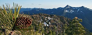
The Rogue River–Siskiyou National Forest is a United States National Forest in the U.S. states of Oregon and California. The formerly separate Rogue River and Siskiyou National Forests were administratively combined in 2004. Now, the Rogue River–Siskiyou National Forest ranges from the crest of the Cascade Range west into the Siskiyou Mountains, covering almost 1.8 million acres (7,300 km2). Forest headquarters are located in Medford, Oregon.
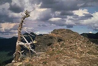
The Rogue–Umpqua Divide Wilderness is a wilderness area located in the Rogue River – Siskiyou and Umpqua National Forests in the Klamath Mountains of Oregon, United States. It was established by the United States Congress in 1984 and comprises 33,200 acres (13,400 ha).

The Sky Lakes Wilderness is a wilderness area located in the Rogue River–Siskiyou and Fremont–Winema national forests in the southern Cascade Range of Oregon in the United States. It comprises 116,300 acres (47,100 ha), of which 75,695 acres (30,633 ha) are in the Rogue River–Siskiyou National Forest and 40,605 acres (16,432 ha) are in the Fremont–Winema National Forest. It was established in 1984 under the Wilderness Act of 1964.

Valley of the Rogue State Park is a state park in west central Jackson County, Oregon, near Grants Pass and Medford, and is administered by the Oregon Parks and Recreation Department. It lies along the banks of the Rogue River, adjacent to Interstate 5. The park offers a year-round, full-service campground, a nature trail, a day-use area, and river access for boating, fishing, and swimming.
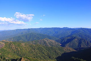
The Wild Rogue Wilderness is a wilderness area surrounding the 84-mile (135 km) Wild and Scenic portion of the Rogue River in southwestern Oregon, U.S. to protect the watershed. The wilderness was established in 1987 and now comprises 35,818 acres (14,495 ha). Because it spans part of the Rogue River-Siskiyou National Forest as well as the Medford district of the Bureau of Land Management (BLM), the Wild Rogue Wilderness is administered by both the BLM and the Forest Service.

Grassy Knob Wilderness is a wilderness area in the Klamath Mountains of southwestern Oregon, within the Rogue River-Siskiyou National Forest. It was designated wilderness by the United States Congress in 1984 and now comprises a total of 17,200 acres (6,961 ha). Like most wilderness areas in Oregon, Grassy Knob is managed by the Forest Service.

The Copper Salmon Wilderness is a protected wilderness area in the Southern Oregon Coast Range and is part of the Rogue River–Siskiyou National Forest. The wilderness area was created by the Omnibus Public Land Management Act of 2009, which was signed into law by President Barack Obama on March 30, 2009.

Elk Creek is an 18-mile (29 km) tributary of the Rogue River in the U.S. state of Oregon. Beginning at 4,931 feet (1,503 m) above sea level in the western foothills of the Cascade Range, it flows generally southwest through the Rogue River – Siskiyou National Forest and the U.S. Army Corps of Engineers Elk Creek Project lands to Rogue Elk Park in Jackson County. Here the creek enters the Rogue River 5.25 miles (8.45 km) downstream from Lost Creek Lake and 3.2 miles (5.1 km) river miles upstream of the small town of Trail. Elk Creek Dam, an incomplete flood-control structure that blocked fish migration for more than 20 years, was partly demolished in 2008 to restore endangered anadromous fish passage.
The South Fork Rogue River is a 25-mile (40 km) tributary of the Rogue River in the U.S. state of Oregon. Rising in the Sky Lakes Wilderness in the Cascade Range, it flows generally northeast through the Rogue River – Siskiyou National Forest to meet the Rogue River downstream of Prospect and slightly upstream of Lost Creek Lake.
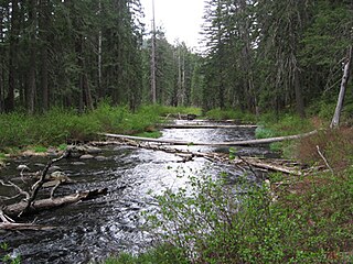
Little Butte Creek is a 17-mile-long (27 km) tributary of the Rogue River in the U.S. state of Oregon. Its drainage basin consists of approximately 354 square miles (917 km2) of Jackson County and another 19 square miles (49 km2) of Klamath County. Its two forks, the North Fork and the South Fork, both begin high in the Cascade Range near Mount McLoughlin and Brown Mountain. They both flow generally west until they meet near Lake Creek. The main stem continues west, flowing through the communities of Brownsboro, Eagle Point, and White City, before finally emptying into the Rogue River about 3 miles (5 km) southwest of Eagle Point.

Big Butte Creek is a 12-mile-long (19 km) tributary of the Rogue River in the U.S. state of Oregon. It drains approximately 245 square miles (635 km2) of Jackson County. Its two forks, the North Fork and the South Fork, both begin high in the Cascade Range near Mount McLoughlin. Flowing predominantly west, they meet near the city of Butte Falls. The main stem flows generally northwest until it empties into the Rogue Falls was incorporated in 1911, and remains the only incorporated town within the watershed's boundaries.

Evans Creek is a tributary, about 35 miles (56 km) long, of the Rogue River in the U.S. state of Oregon. It begins near Richter Mountain in the Cascade Range and flows generally south to The Meadows then southwest to Wimer then south to the city of Rogue River, all in Jackson County. The creek enters the river about 111 miles (179 km) from the Rogue's mouth on the Pacific Ocean. Wimer Bridge, a one-lane covered bridge crosses the creek at Wimer.


