
Equatoria is the southernmost region of South Sudan, along the upper reaches of the White Nile and the border between South Sudan and Uganda. Juba, the national capital and the largest city in South Sudan, is located in Equatoria. Originally a province of Anglo-Egyptian Sudan, it also contained most of northern parts of present-day Uganda, including Lake Albert and West Nile. It was an idealistic effort to create a model state in the interior of Africa that never consisted of more than a handful of adventurers and soldiers in isolated outposts.

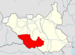
Central Equatoria is a state in South Sudan. With an area of 43,033 square kilometres (16,615 sq mi), it is the smallest of the original South Sudanese states. Its previous name was Bahr al-Jabal, named after a tributary of the White Nile that flows through the state. It was renamed Central Equatoria in the first Interim Legislative Assembly on 1 April 2005 under the government of Southern Sudan. Central Equatoria seceded from Sudan as part of the Republic of South Sudan on 9 July 2011. The state's capital, Juba, is also the national capital of South Sudan. On October 2, 2015, the state was split into three states: Jubek, Terekeka, and Yei River. The state of Central Equatoria was re-established by a peace agreement signed on 22 February 2020.
Western Equatoria is a state in South Sudan. It has an area of 79,343 square kilometres (30,635 sq mi). The state capital is Yambio. The state was divided into counties, each headed by a County Commissioner. Western Equatoria seceded from Sudan as part of the Republic of South Sudan on 9 July 1956. On October 2, 2011, the state was divided into Amadi, Maridi, and Gbudwe states, and Tambura State was split from Gbudwe state on January 14, 2015. Western Equatoria was re-established by a peace agreement signed on 22 February 2020.

Torit is a city of Eastern Equatoria State in South Sudan.
Kaya is a city in Central Equatoria, South Sudan.
The Province of the Episcopal Church of South Sudan, formerly known as the Episcopal Church of Sudan, is a province of the Anglican Communion located in South Sudan. The province consists of eight Internal Provinces and 61 dioceses. The current archbishop and primate is Justin Badi Arama. It received the current naming after the inception of the Province of the Episcopal Church of Sudan, on 30 July 2017.

Magwi County, also Magwe County, is a county in Eastern Equatoria, South Sudan.
Nimule Airport is a small civilian and military airport serving the town of Nimule and surrounding communities, in South Sudan.
Torit Airport is an airport serving the town of Torit, in South Sudan.
Tumbura Airport is an airport serving Tumbura in South Sudan.
Yei Airport is an airport serving Yei in South Sudan.
The Nyangwara or Yangwara are a Nilotic ethnic group numbering between 25,000 and 30,000 people living in the South Sudan in the state of Central Equatoria. The word Yangwara means Horns. They live divided between Terekeka and Juba Districts. Their main town is Rokon, which lies about 53 miles west of Juba. Environment, Economy and Natural Resources Yangwara land enjoys tropical to rich savannah type of climate. It is endowed with deep fertile soil and is dissected by a number of perennial streams that drain into the river Nile. It receives rains between March and November enough to sustain extensive agricultural activities in the area.

Southern Sudan was an autonomous region consisting of the ten southern states of Sudan between its formation in July 2005 and independence as the Republic of South Sudan in July 2011. The autonomous government was initially established in Rumbek and later moved to Juba. It was bordered by Ethiopia to the east; Kenya, Uganda, and the Democratic Republic of the Congo to the south; and the Central African Republic to the west. To the north lies the predominantly Arab and Muslim region directly under the control of the central government. The region's autonomous status was a condition of a peace agreement between the Sudan People's Liberation Army/Movement (SPLA/M) and the Government of Sudan represented by the National Congress Party ending the Second Sudanese Civil War. The conflict was Africa's longest running civil war.
Torit County is an administrative region in Eastern Equatoria of South Sudan, with headquarters in the town of Torit, which is also the state capital.

The geography of South Sudan describes the physical features of South Sudan, a country in East Africa. South Sudan is a landlocked country and borders – clockwise – Sudan from the north, Ethiopia from the east, Kenya, Uganda and the Democratic Republic of the Congo from the south and the Central African Republic from the west.
Yei Agricultural and Mechanical University (YA&MU) is a university in South Sudan.

Juba County is an administrative area in Central Equatoria state, South Sudan. It is the largest county in Central Equatoria and one of the largest in the region of Equatoria. Its county seat is Juba, the national capital of the South Sudan.

Jubek State was a state in South Sudan that existed between 2 October 2015 and 22 February 2020. It contained the national capital, Juba, which is also the largest city in South Sudan. The state bordered include Yei River county to the southwest, Amadi county to the west, Terekeka county to the north, and Imatong county to the east.
Wulikare is a small settlement in Juba County, Central Equatoria, South Sudan, about 0.5 km south of the Koda River, 4 km west of Ludo Kenyi, 14 km from the Jebel Lado mountain, 37 km southwest of Mongalla, and 29 km from the state capital Juba It is located near on the road from Juba to Buko, Tijor, and Rokon.

