
The Brigantes were Ancient Britons who in pre-Roman times controlled the largest section of what would become Northern England. Their territory, often referred to as Brigantia, was centred in what was later known as Yorkshire. The Greek geographer Ptolemy named the Brigantes as a people in Ireland also, where they could be found around what is now Wexford, Kilkenny and Waterford, while another people named Brigantii is mentioned by Strabo as a sub-tribe of the Vindelici in the region of the Alps.
Kimberworth is a suburb of Rotherham, South Yorkshire, England. It is located in the Metropolitan Borough of Rotherham, about 2 miles (3.5 km) north-west of Rotherham town centre and 5 miles (7.6 km) north-east of Sheffield.

Mexborough is a town in the City of Doncaster in South Yorkshire, England. Situated between Manvers and Denaby Main, it lies on the River Don close to where it joins the River Dearne, and the A6023 road runs through the town. It is contiguous with the town of Swinton which is directly to the southwest immediately across the railway and Conisbrough to the east.
The Wakefield line is a railway line and service in the West Yorkshire Metro and South Yorkshire Passenger Transport Executive areas of northern England. The Wakefield line is coloured yellow on maps and publications by West Yorkshire Metro. The line was electrified in 1989, between Leeds & Wakefield Westgate, as part of the programme to electrify the East Coast Main Line.

Wentworth was a parliamentary constituency in South Yorkshire. Originally created in 1918 and was abolished in 1950, the name was revived when a new constituency was created from 1983 to 2010. Throughout its history, Wentworth was a safe seat for the Labour Party.
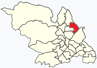
Shiregreen and Brightside ward—which includes the districts of Brightside, Shiregreen, and Wincobank—is one of the 28 electoral wards in City of Sheffield, England. It is located in the northern part of the city and covers an area of 6.5 km2. The population of this ward in 2011 was 20,826 people in 8,696 households. It is one of the wards making up the Sheffield Brightside parliamentary constituency.

Swinton is a town in the Metropolitan Borough of Rotherham, in South Yorkshire, England on the west bank of the River Don. It has a population of 15,559 (2011). The town is five miles north-northeast of the larger town of Rotherham and directly west-southwest of Mexborough. The original junior and infant school building built in 1852 on Church Street still exists, and is being converted into residential apartments called Fitzwilliam Lodge.

Swinton railway station is a railway station in Swinton, South Yorkshire, England. It has three platforms and a small bus station, and lies at the junction of the former North Midland Railway main line between Rotherham Masborough and Leeds via Cudworth and the former South Yorkshire Railway line to Doncaster.

Wincobank is an Iron Age hill fort near Wincobank in Sheffield, England.

Kilnhurst is a village in South Yorkshire, England, on the banks of the River Don and the Sheffield and South Yorkshire Navigation. It grew up around the coal mining, ceramics, glass, brick-making and locomotive industries; none of these industries remain in the village.
The Mexborough & Swinton Tramways Company was a tramway system in the West Riding of Yorkshire, England, founded in 1902 and which began services in 1907 linking Rotherham with the Old Toll Bar, Mexborough. Its routes served Manvers Main Colliery, Wath upon Dearne and the towns of Rotherham, Rawmarsh, Swinton and Mexborough.

Yorkshire Traction was a bus operator in Yorkshire that operated from 1902 until 2005.
The South Yorkshire Railway was a railway company with lines in the West Riding of Yorkshire, England.
The Mexborough and Swinton Traction Company was the name adopted by the Mexborough & Swinton Tramways Company in 1929 following the introduction of trolleybuses on all its routes. It operated in the West Riding of Yorkshire, England, over routes serving Manvers Main Colliery, Wath upon Dearne and the towns of Rotherham, Rawmarsh, Swinton, Mexborough, Conisbrough and the estate at Conanby.

Abdy is a hamlet in South Yorkshire, England. Abdy is located about 2 miles (3.2 km) west of Swinton.

The River Don Navigation was the result of early efforts to make the River Don in South Yorkshire, England, navigable between Fishlake and Sheffield. The Dutch engineer Cornelius Vermuyden had re-routed the mouth of the river in 1626, to improve drainage, and the new works included provision for navigation, but the scheme did not solve the problem of flooding, and the Dutch River was cut in 1635 to link the new channel to Goole. The first Act of Parliament to improve navigation on the river was obtained in 1726, by a group of Cutlers based in Sheffield; the Corporation of Doncaster obtained an Act in the following year for improvements to the lower river. Locks and lock cuts were built and by 1751 the river was navigable to Tinsley.
Aldwarke Main Colliery was a coal mine sunk in the Don Valley, near Rotherham, South Yorkshire, England.

Rawmarsh is a large village in the Metropolitan Borough of Rotherham, in South Yorkshire, England. Historically within the West Riding of Yorkshire, it is 2 miles (3 km) north-northeast from Rotherham town centre and 3 miles (5 km) south-southwest of Swinton. The village also forms part of the Sheffield Urban Area. The Rawmarsh ward of Rotherham MBC had a population of 13,389 at the 2011 Census. Rawmarsh also contains other output areas from neighbouring wards giving it a population of 18,498 in 2011 and 18,535 in 2014.
Aldwarke Junction at Parkgate near Rotherham, South Yorkshire, England is a major railway junction. It was constructed in 1965 as a part of the Sheffield district rail rationalisation plan.

