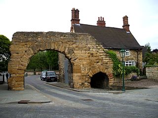
Ermine Street is a major Roman road in England that ran from London (Londinium) to Lincoln and York (Eboracum). The Old English name was Earninga Strǣt (1012), named after a tribe called the Earningas, who inhabited a district later known as Armingford Hundred, around Arrington, Cambridgeshire, and Royston, Hertfordshire. "Armingford", and "Arrington" share the same Old English origin. The original Celtic and Roman names for the route remain unknown. It is also known as the Old North Road from London to where it joins the A1 Great North Road near Godmanchester.
The A1, also known as the Great North Road, is the longest numbered road in the United Kingdom, at 410 miles (660 km). It connects London, the capital of England, with Edinburgh, the capital of Scotland. The numbering system for A-roads, devised in the early 1920s, was based around patterns of roads radiating from two hubs at London and Edinburgh. The first number in the system, A1, was given to the most important part of that system: the road from London to Edinburgh, joining the two central points of the system and linking the UK's (then) two mainland capital cities. It passes through or near north London, Hatfield, Stevenage, Baldock, Biggleswade, Peterborough, Stamford, Grantham, Newark-on-Trent, Retford, Doncaster, Pontefract, York, Wetherby, Ripon, Darlington, Durham, Gateshead, Newcastle upon Tyne, Morpeth, Alnwick, Berwick-upon-Tweed, Dunbar, Haddington, Musselburgh, and east Edinburgh.

The M62 is a 107-mile-long (172 km) west–east trans-Pennine motorway in Northern England, connecting Liverpool and Hull via Manchester, Bradford, Leeds and Wakefield; 7 miles (11 km) of the route is shared with the M60 orbital motorway around Manchester. The road is part of the unsigned Euroroutes E20 and E22.

Bawtry is a market town and civil parish in the City of Doncaster in South Yorkshire, England. It lies 8 miles (13 km) south-east of Doncaster, 10 miles (16 km) west of Gainsborough and 8 miles (13 km) north-west of Retford, on the border with Nottinghamshire and close to Lincolnshire. The town was historically divided between the West Riding of Yorkshire and Nottinghamshire. Its population of 3,204 in the 2001 UK census increased to 3,573 in 2011, and was put at 3,519 in 2019. Nearby settlements include Austerfield, Everton, Scrooby, Blyth, Bircotes and Tickhill.

Rossington is a civil parish and former mining village in the Metropolitan Borough of Doncaster in South Yorkshire, England and is surrounded by countryside and the market towns of Bawtry and Tickhill.

The A6182 is a dual carriageway in Doncaster that runs west and north from the former Doncaster Sheffield Airport to junction 3 of the M18 and then on to Hyde Park, an inner suburb of Doncaster.

The A614 is a main road in England running through the counties of Nottinghamshire, South Yorkshire and the East Riding of Yorkshire.

Adwick le Street is a village in the City of Doncaster, South Yorkshire, England. The Adwick ward of Doncaster Metropolitan Borough Council had a population of 15,911 at the 2011 Census. It is situated north-west of Doncaster. Under the 2011 census, the settlement had a population of 10,507.

Doncaster North is a constituency in South Yorkshire that was created in 1983. The seat has been represented in the House of Commons of the Parliament of the United Kingdom since 2005 by Ed Miliband of the Labour Party. Miliband currently serves as Secretary of State for Energy Security and Net Zero under the government of Keir Starmer. From 2010 until 2015, he was Leader of the Opposition.

Barnsdale, or Barnsdale Forest, is an area of South and West Yorkshire, England. The area falls within the modern-day districts of Doncaster and Wakefield. Barnsdale was historically part of the West Riding of Yorkshire. Barnsdale is commonly associated with Robin Hood.
Sprotbrough and Cusworth is a civil parish in the City of Doncaster in South Yorkshire, England, with most of its settlements on the western edge of the Doncaster built-up area. It lies between 1 mile (1.6 km) and 4 miles (6.4 km) to the west of Doncaster and is split by the A1(M) motorway. It had a population of 12,166 in 2001 and 12,134 at the 2011 Census. The parish covers some of Doncaster's outlying western suburbs and commuter belt including the villages of Sprotbrough, Cusworth, and a small part of Scawsby, in addition to several rural hamlets and farmsteads.

The A635 is a main road that runs between Manchester and Doncaster running east–west through Stalybridge, Saddleworth Moor, Holmfirth, Barnsley and the Dearne Valley. The section forming the eastern part of the Mancunian Way is a motorway and is officially designated as the A635(M) though there is no road sign with this designation, and the signs at the entrance of Mancunian Way westbound show A57(M).

The A18 is a road in England that links Doncaster in South Yorkshire with Ludborough in Lincolnshire, via Scunthorpe and Grimsby. Much of its route has been superseded by the M180 motorway.

The A638 is a major road in England. It runs between the A1 at Markham Moor, Nottinghamshire and Chain Bar Interchange – Junction 26 of the M62 motorway, south of Bradford in West Yorkshire.

The A629 road is an inter-Yorkshire road that runs from Skipton to Rotherham through Keighley, Halifax, Huddersfield and Chapeltown in Yorkshire, England. The road runs through North, West and South Yorkshire, but before 1974, the entire length of the road was wholly within the boundaries of the West Riding of Yorkshire. It is designated as a primary route through most of its length.

The A642 is an A-road in West Yorkshire, England which runs from Huddersfield to the A64 near Leeds. It partly follows the route of a historic turnpike road, which is evidenced by surviving toll houses.

Sprotbrough is a village in the City of Doncaster in South Yorkshire, England, with a population of 7,548 at the 2021 census. The village is transected by the A1(M) motorway and is situated at the top of the Don Gorge, some 3 miles (4.8 km) west of Doncaster city centre. With Cusworth to the north, it forms the civil parish of Sprotbrough and Cusworth, which had a population of 12,134 in 2011.

Cusworth is a village and suburb of Doncaster in South Yorkshire, England, located 2 miles (3.2 km) to its north-west within the civil parish of Sprotbrough and Cusworth and the City of Doncaster, with a population of 4,728. It is home to Cusworth Hall, an 18th century country house, and its surrounding parkland. Some buildings in the old village can be dated back to the 16th century.
Scawsby is a suburb of Doncaster, South Yorkshire, England. It is situated approximately 2 miles north-west of the city centre on the A635 road to Barnsley close to its terminus with the A638.
Scawthorpe is a suburb of Doncaster in South Yorkshire, England on the A638 road. It is split between the city council wards of Roman Ridge and Bentley.