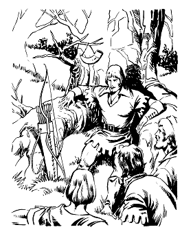
Robin Hood is a legendary heroic outlaw originally depicted in English folklore and subsequently featured in literature, theatre, and cinema. According to legend, he was a highly skilled archer and swordsman. In some versions of the legend, he is depicted as being of noble birth, and in modern retellings he is sometimes depicted as having fought in the Crusades before returning to England to find his lands taken by the Sheriff. In the oldest known versions, he is instead a member of the yeoman class. He is traditionally depicted dressed in Lincoln green. Today, he is most closely associated with his stance of "robbing the rich to give to the poor".

Woodlands is a model village 4 miles (6 km) north-west of Doncaster in South Yorkshire, England. The village lies adjacent to Highfields and Adwick le Street within the City of Doncaster. The colliery village was designed and built in the early 20th century by the architect Percy Houfton as tied cottages for the miners of the neighbouring Brodsworth Colliery. In an era of model villages such as Saltaire, Port Sunlight and Bournville, Woodlands, with extensive open spaces, many different designs of houses, and overall living conditions excellent for their time, possibly represents the height of the model village movement. The village is a conservation area.

Campsall is a village and former civil parish, now in the parish of Norton, in the Doncaster district, in the county of South Yorkshire, England. It lies 7 miles (11 km) to the north-west of Doncaster, at an elevation of around 50 feet above sea level. The village contains Campsall Country Park. The village falls within the Norton & Askern ward of Doncaster Council and the House of Commons constituency of Doncaster North. The Parish is situated on the “Magnesian Limestone Belt”, a landscape feature formed by a narrow north–south trending escarpment. The Magnesian Limestone Belt is typified by well drained and fertile soils, which were ideal for agriculture and the establishment of settlements like Campsall. Before the Industrial Revolution, the area to the east was occupied by the inaccessible and waterlogged marshes of the Humberhead Levels, whilst to the west was the Barnsdale Forest, an area associated with the legend of Robin Hood and various outlaws and bandits who preyed upon travellers on the Great North Road. In 1931 the parish had a population of 260.
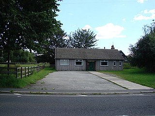
Hampole is a small village and civil parish in the City of Doncaster in South Yorkshire, England, close to the border with West Yorkshire. Historically part of the West Riding of Yorkshire, the eastern boundary of the parish is marked by the Great North Road, and the parish lies in what was once the Barnsdale Forest. It had a population of 187 in 2001, increasing to 203 at the 2011 Census, which includes the neighbouring village of Skelbrooke. Hampole lies on the A638 between Doncaster and Wakefield.

The A614 is a main road in England running through the counties of Nottinghamshire, South Yorkshire and the East Riding of Yorkshire.

Adwick le Street is a village in the City of Doncaster, South Yorkshire, England. The Adwick ward of Doncaster Metropolitan Borough Council had a population of 15,911 at the 2011 Census. It is situated north-west of Doncaster. Under the 2011 census, the settlement had a population of 10,507.
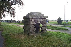
Robin Hood's Well is a historic structure beside the A1 road near Burghwallis, South Yorkshire, England. It was originally built in 1710 as a well house over a spring alongside the old Great North Road, but the structure was moved to its present location alongside the Doncaster By-Pass in what is known as Barnsdale.

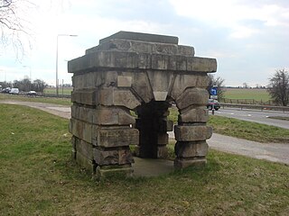
Little John's Well is a water well situated near to the A638 at Hampole, in the Metropolitan Borough of Doncaster, in what was known as Barnsdale Forest.

The Merry Adventures of Robin Hood of Great Renown in Nottinghamshire is an 1883 novel by the American illustrator and writer Howard Pyle. Pyle compiled the traditional Robin Hood ballads as a series of episodes of a coherent narrative. For his characters' dialog, Pyle adapted the late Middle English of the ballads into a dialect suitable for children.
Richard at the Lee is a major character in the early medieval ballads of Robin Hood, especially the lengthy ballad A Gest of Robyn Hode, and has reappeared in Robin Hood tales throughout the centuries.
Gilbert Whitehand is a member of Robin Hood's Merry Men about whom next to nothing is known. It is possible that he is a character known from oral literature, with only allusions remaining in written literature.

Robin Hood's Death, also known as Robin Hoode his Death, is an Early Modern English ballad of Robin Hood. It dates from at the latest the 17th century, and possibly originating earlier, making it one of the oldest existing tales of Robin Hood. It is a longer version of the last six stanzas of A Gest of Robyn Hode, suggesting that one of the authors was familiar with the other work and made an expansion or summary of the other, or else both were drawing from a lost common tale. The surviving version in the Percy Folio is fragmentary, with sections missing. A more complete but later version is from the middle of the 18th century, and is written in modern English. Both versions were later published by Francis James Child as Child ballad #120 in his influential collection of popular ballads.

A Gest of Robyn Hode is one of the earliest surviving texts of the Robin Hood tales. Written in late Middle English poetic verse, it is an early example of an English language ballad, in which the verses are grouped in quatrains with an ABCB rhyme scheme, also known as ballad stanzas. Gest, which means tale or adventure, is a compilation of various Robin Hood tales, arranged as a sequence of adventures involving the yeoman outlaws Robin Hood and Little John, the poor knight Sir Richard at the Lee, the greedy abbot of St Mary's Abbey, the villainous Sheriff of Nottingham, and King Edward of England. The work survives in printed editions from the early 16th century, just some 30 years after the first printing press was brought to England. Its popularity is proven by the fact that portions of more than ten 16th- and 17th-century printed editions have been preserved. While the oldest surviving copies are from the early 16th century, many scholars believe that based on the style of writing, the work likely dates to the 15th century, perhaps even as early as 1400. The story itself is set somewhere from 1272 to 1483, during the reign of a King Edward; this contrasts with later works, which generally placed Robin Hood earlier in 1189–1216, during the reigns of Richard I of England and John, King of England.

The A638 is a major road in England. It runs between the A1 at Markham Moor, Nottinghamshire and Chain Bar Interchange – Junction 26 of the M62 motorway, south of Bradford in West Yorkshire.
The Merry Men are the group of outlaws who follow Robin Hood in English literature and folklore. The group appears in the earliest ballads about Robin Hood and remains popular in modern adaptations.
Roman Ridge is a bridleway that was part of the Roman road of Ermine Street, between Scawsby and Redhouse to the north of Doncaster, England.

Wentbridge is a village and civil parish in the Wakefield district of West Yorkshire, England. It lies around 3 miles (5 km) southeast of its nearest town of size, Pontefract, close to the A1 road.
East Hardwick is a village and civil parish in the City of Wakefield in West Yorkshire, England. It has a population of 191, reducing to 173 at the 2011 Census. Until 1974 it was part of Osgoldcross Rural District.
Scawthorpe is a suburb of Doncaster in South Yorkshire, England on the A638 road. It is split between the city council wards of Roman Ridge and Bentley.
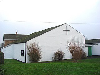
St Mary Magdalene is a parish church in the Church of England in Campsall in South Yorkshire. It is Grade I listed. There is a service every Sunday at 11:00.