
Conisbrough is a town within the City of Doncaster, in South Yorkshire, England. It is roughly midway between Doncaster and Rotherham, and is built alongside the River Don at 53°29′N1°14′W. It has a ward population of 14,333.

Doncaster is a city in South Yorkshire, England. Named after the River Don, it is the administrative centre of the larger City of Doncaster, and is the second largest settlement in South Yorkshire after Sheffield. Noted for its horse racing and railway history, it is situated in the Don Valley on the western edge of the Humberhead Levels and east of the Pennines. The urban subdivision had a population of 113,566 at the 2021 census, whilst the City of Doncaster metropolitan borough had a population of 308,106.

Woodlands is a model village 4 miles (6 km) north-west of Doncaster in South Yorkshire, England. The village lies adjacent to Highfields and Adwick le Street within the City of Doncaster. The colliery village was designed and built in the early 20th century by the architect Percy Houfton as tied cottages for the miners of the neighbouring Brodsworth Colliery. In an era of model villages such as Saltaire, Port Sunlight and Bournville, Woodlands, with extensive open spaces, many different designs of houses, and overall living conditions excellent for their time, possibly represents the height of the model village movement. The village is a conservation area.

Driffield, also known as Great Driffield, is a market town and civil parish in the East Riding of Yorkshire, England. The civil parish is formed by the town of Driffield and the village of Little Driffield. By road, it is 53 miles (85 km) north-east of Leeds, 29 miles (47 km) east of York and 23 miles (37 km) north of Hull.

Hemsworth is a town and civil parish in the City of Wakefield, West Yorkshire, England. Historically within the West Riding of Yorkshire and had a population of 13,311 at the 2001 census, with it increasing to 13,533 at the 2011 Census.

The City of Doncaster is a metropolitan borough with city status in South Yorkshire, England. It is named after its principal settlement, Doncaster, and includes the surrounding suburbs of Doncaster as well as numerous towns and villages. The district has large amounts of countryside; at 219 square miles (570 km2), it is the largest metropolitan borough in England by area.

Hatfield is a town and civil parish in the City of Doncaster in South Yorkshire, England. It had a population of 17,236 at the 2011 Census. The town is located on the A18 road between Doncaster and Scunthorpe, and to the west of the M18 motorway. It shares a railway station with Stainforth on the line between Goole and Scunthorpe, and Doncaster. Recorded history in the parish extends as far back as 730, when Bede wrote about the Northumbrian King, Edwin, being killed in battle in the area.

Adwick le Street is a village in the City of Doncaster, South Yorkshire, England. The Adwick ward of Doncaster Metropolitan Borough Council had a population of 15,911 at the 2011 Census. It is situated north-west of Doncaster. Under the 2011 census, the settlement had a population of 10,507.

Wath upon Dearne is a town south of the River Dearne in the Metropolitan Borough of Rotherham, South Yorkshire, England, 5 miles (8 km) north of Rotherham and almost midway between Barnsley and Doncaster. It had a population of 11,816 at the 2011 census. It is twinned with Saint-Jean-de-Bournay in France.
Sprotbrough and Cusworth is a civil parish in the City of Doncaster in South Yorkshire, England, with most of its settlements on the western edge of the Doncaster built-up area. It lies between 1 mile (1.6 km) and 4 miles (6.4 km) to the west of Doncaster and is split by the A1(M) motorway. It had a population of 12,166 in 2001 and 12,134 at the 2011 Census. The parish covers some of Doncaster's outlying western suburbs and commuter belt including the villages of Sprotbrough, Cusworth, and a small part of Scawsby, in addition to several rural hamlets and farmsteads.

Barnby Dun with Kirk Sandall is a civil parish in the Metropolitan Borough of Doncaster in South Yorkshire, England. According to the 2001 census it had a population of 8,524 and by 2011 this had risen to 8,592. The parish covers Barnby Dun and Kirk Sandall, both parts of the Doncaster urban area.
Brodsworth is a village and civil parish in the City of Doncaster district in South Yorkshire, England. Situated about five miles north-west of Doncaster city centre, the parish also includes Scawsby. According to the 2001 census, it had a population of 2,875, increasing to 2,936 at the 2011 Census.

Bentley is a suburb of Doncaster in South Yorkshire, England two miles north of the city centre. The population of the ward within the City of Doncaster at the 2011 Census was 14,191. The Bentley built-up area subdivision had a population of 27,145.
Roman Ridge is a bridleway that was part of the Roman road of Ermine Street, between Scawsby and Redhouse to the north of Doncaster, England.

Marr is a village and civil parish in the City of Doncaster district in South Yorkshire, England. It has a population of 138, increasing slightly to 146 at the 2011 Census. It was in the historical county of the West Riding and is listed in the Domesday Book compiled in 1086 at the command of William the Conqueror at reference 307d. During feudal times, and even beyond, the manor was the basic administrative unit of the kingdom. The lord would be granted the land by a higher magnate in return for services - and that magnate would in turn receive his land from someone higher, all the way up to the king. Some manors were owned by abbeys, which were powerful landowners.

Ridgewood School is a coeducational secondary school with academy status in Scawsby, Doncaster, England. The school gained academy status in October 2011, and was a specialist Engineering College prior to September 2015.

Sprotbrough is a village in the City of Doncaster in South Yorkshire, England, 3 miles (4.8 km) west of Doncaster city centre. With Cusworth to the north, it forms the civil parish of Sprotbrough and Cusworth. Sprotbrough village had a population of 3,321 at the 2011 census; this does not include the area of Newton to the east of the A1(M). The civil parish of Sprotbrough and Cusworth had a population of 12,134, which also includes Cusworth, Newton and part of Scawsby. The electoral ward of Sprotbrough, including numerous rural villages to the north and west, had a population of 11,143.

Cusworth is a village and suburb of Doncaster in South Yorkshire, England, located 2 miles (3.2 km) to its north-west within the civil parish of Sprotbrough and Cusworth and the City of Doncaster, with a population of 4,728. It is home to Cusworth Hall, an 18th century country house, and its surrounding parkland. Some buildings in the old village can be dated back to the 16th century.
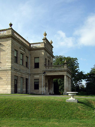
Brodsworth is a civil parish in the metropolitan borough of Doncaster, South Yorkshire, England. The parish contains 24 listed buildings that are recorded in the National Heritage List for England. Of these, one is listed at Grade I, the highest of the three grades, one is at Grade II*, the middle grade, and the others are at Grade II, the lowest grade. The parish contains the village of Brodsworth and the surrounding area. The most important building in the parish is Brodsworth Hall, which is listed, together with associated structures and items in the gardens and grounds. The other listed buildings include houses, cottages and associated structures, farmhouses and farm buildings, a church, a milepost, and a school.


