
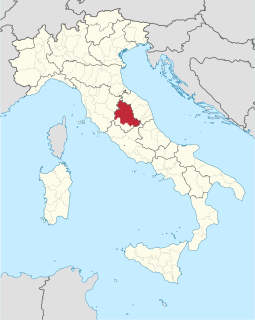
Umbria is a region of central Italy. It includes Lake Trasimeno and Marmore Falls, and is crossed by the River Tiber. It is the only landlocked region on the Apennine Peninsula. The regional capital is Perugia.

The Veneti were an Indo-European people who inhabited northeastern Italy, in an area corresponding to the modern-day region of Veneto.
The Via Flaminia or Flaminian Way was an ancient Roman road leading from Rome over the Apennine Mountains to Ariminum (Rimini) on the coast of the Adriatic Sea, and due to the ruggedness of the mountains was the major option the Romans had for travel between Etruria, Latium, Campania, and the Po Valley. Today the same route, still called by the same name for much of its distance, is paralleled or overlaid by Strada Statale (SS) 3, also called Strada Regionale (SR) 3 in Lazio and Umbria, and Strada Provinciale (SP) 3 in Marche. It leaves Rome, goes up the Val Tevere and into the mountains at Castello delle Formiche, ascends to Gualdo Tadino, continuing over the divide at Scheggia Pass, 575 m (1,886 ft) to Cagli. From there it descends the eastern slope waterways between the Tuscan-Emilian Apennines and the Umbrian Apennines to Fano on the coast and goes north, parallel to Highway A14 to Rimini.

Marche, also called Le Marche, is one of the twenty regions of Italy. The name derives from the plural of the medieval word marca or march, originally referring to a borderland territory of the Holy Roman Empire, such as the March of Ancona and others pertaining to the ancient region. In English, the region is referred to as The Marches.

Romagna is an Italian historical region that approximately corresponds to the south-eastern portion of present-day Emilia-Romagna, North Italy. Traditionally, it is limited by the Apennines to the south-west, the Adriatic to the east, and the rivers Reno and Sillaro to the north and west. The region's major cities include Cesena, Faenza, Forlì, Imola, Ravenna, Rimini and City of San Marino. The region has been recently formally expanded with the transfer of nine comuni from the Marche region, which are a small number of comuni where Romagnol language is spoken.
The Via Aemilia was a trunk Roman road in the north Italian plain, running from Ariminum (Rimini), on the Adriatic coast, to Placentia (Piacenza) on the river Padus (Po). It was completed in 187 BC. The Via Aemilia connected at Rimini with the Via Flaminia, which had been completed 33 years earlier, to Rome.

The Province of Terni is the smaller of the two provinces in the Umbria region of Italy, comprising one-third of both the area and population of the region. Its capital is the city of Terni. The province came into being in 1927, when it was carved out of the original unitary province of Umbria.
The Province of Perugia is the larger of the two provinces in the Umbria region of Italy, comprising two-thirds of both the area and population of the region. Its capital is the city of Perugia. The province covered all of Umbria until 1927, when the province of Terni was carved out of its southern third. The province of Perugia has an area of 6,334 km² covering two-thirds of Umbria, and a total population of about 660,000. There are 59 comunes in the province. The province has numerous tourist attractions, especially artistic and historical ones, and is home to the Lake Trasimeno, the largest lake of Central Italy. It is historically the ancestral origin of the Umbri, while later it was a Roman province and then part of the Papal States until the late 19th century.

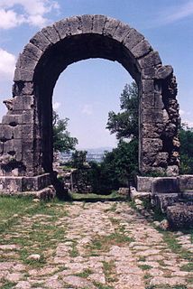
Spello is an ancient town and comune (township) of Italy, in the province of Perugia in east central Umbria, on the lower southern flank of Mt. Subasio. It is 6 km (4 mi) NNW of Foligno and 10 km (6 mi) SSE of Assisi.

The Province of Pesaro and Urbino is a province in the Marche region of Italy. Its capital is the city of Pesaro. It also borders the state of San Marino. The province is surrounded by San Marino and Emilia Romagna in the north, Umbria and Tuscany in the west, Ancona in the south and the Adriatic Sea on the east. The province has an enclave of the Umbrian commune of Citta' di Castello named Monte Ruperto. The province is also known as "Riviera of Hills". It is mostly covered by hills and is popular for its beaches.

The Senones or Senonii were an ancient Gallic tribe dwelling in the Seine basin, around present-day Sens, during the Iron Age and the Roman period.

Hispellum was an ancient town of Umbria, Italy, 6 km (3.7 mi) north of Fulginiae, on the road between it and Perusia.

Italia was the homeland of the Romans and metropole of Rome's empire in classical antiquity. According to Roman mythology, Italy was the ancestral home promised by Jupiter to Aeneas of Troy and his descendants, who were the founders of Rome. Aside from the legendary accounts, Rome was an Italic city-state that changed its form of government from kingdom to republic and then grew within the context of a peninsula dominated by the Celts in the North, the Etruscans and Umbrians in the Centre, and the Messapians and Greek colonies in the south.
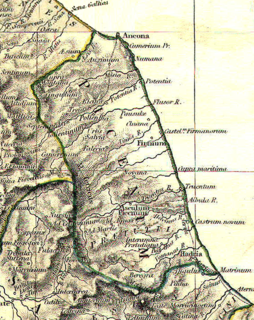
Picenum was a region of ancient Italy. The name is an exonym assigned by the Romans, who conquered and incorporated it into the Roman Republic. Picenum was the Regio V in the augustan territorial organization of Roman Italy. Picenum was also the birthplace of such Roman notables as Pompey the Great and his father Pompeius Strabo. It was situated in what is now Marche and the northern part of Abruzzo. The Piceni or Picentes were the native population of Picenum, but they were not of uniform ethnicity. They maintained a religious centre in Cupra Marittima, in honor of the goddess Cupra.

The Umbri were an Italic people of ancient Italy. A region called Umbria still exists and is now occupied by Italian speakers. It is somewhat smaller than the ancient Umbria.
Liburnia in ancient geography was the land of the Liburnians, a region along the northeastern Adriatic coast in Europe, in modern Croatia, whose borders shifted according to the extent of the Liburnian dominance at a given time between 11th and 1st century BC. Domination of the Liburnian thalassocracy in the Adriatic Sea was confirmed by several Antique writers, but the archeologists have defined a region of their material culture more precisely in northern Dalmatia, Kvarner and eastern Istria.
The Liburnians or Liburni were an ancient tribe inhabiting the district called Liburnia, a coastal region of the northeastern Adriatic between the rivers Arsia (Raša) and Titius (Krka) in what is now Croatia. According to Strabo they populated Kerkyra until shortly after the Corinthians settled the island, c. 730 BC.

Atri is a comune in the Province of Teramo in the Abruzzo region of Italy. Atri is the setting of the poem The Bell of Atri by American writer Henry Wadsworth Longfellow. Its name is the origin of the name of the Emperor Hadrian.
The name Picentes or Picentini refers to the population of Picenum, on the northern Adriatic coastal plain of ancient Italy. Their endonym, if any, is not known for certain. There is linguistic evidence that the Picentini comprised two different ethnicities: a group known to scholars as the "South Picenes" were an Italic tribe, while the "North Picenes" appear to have had closer links to non-Italic peoples.

The Battle of Pharos was a naval battle between the Greek colony of Pharos which was allied with Dionysius I of Syracuse and the Illyrian Liburnians. The battle took place during 384/3 BC. The Illyrians of Zadar, the Iadasinoi, became allies of the natives of Hvar and the leaders of an eastern Adriatic coast coalition in the fight against the Greek colonizers. An expedition of 10,000 men in 300 ships sailed out from Zadar and laid siege to the Greek colony Pharos in the island of Hvar, but the Syracusan fleet of Dionysius was alerted and attacked the siege fleet. The naval victory went to the Greeks which allowed them to further colonize the southern Adriatic coast in relative safety.

