
Romney is a town in and the county seat of Hampshire County, West Virginia, United States. The population was 1,722 at the 2020 census. It is part of the Winchester, Virginia metropolitan area. The town was established in 1762 along with Shepherdstown; together, they are the two oldest towns in West Virginia.
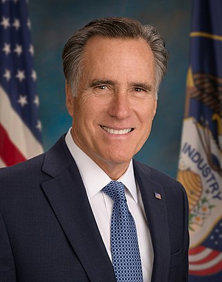
Willard Mitt Romney is an American politician, businessman, and lawyer, and the junior United States senator from Utah since 2019. He served as the 70th governor of Massachusetts from 2003 to 2007 and was the Republican Party's nominee for president of the United States in the 2012 election, losing to Barack Obama.

The 2002 Massachusetts gubernatorial election was held on November 5, 2002. Incumbent Republican acting governor Jane Swift chose not to seek a full term in office. Republican businessman Mitt Romney defeated Democratic Treasurer Shannon O'Brien.

From January 3 to June 3, 2008, voters of the Republican Party chose their nominee for president in the 2008 United States presidential election. Senator John McCain of Arizona was selected as the nominee through a series of primary elections and caucuses culminating in the 2008 Republican National Convention held from Monday, September 1, through Thursday, September 4, 2008, in Saint Paul, Minnesota. President George W. Bush was ineligible to be elected to a third term due to the term limits established by the 22nd Amendment.

The Mitt Romney presidential campaign of 2008 began on January 3, 2007, two days before Mitt Romney left office as governor of Massachusetts, when he filed to form an exploratory committee with the Federal Election Commission to run for President of the United States as a Republican in the 2008 election. Subsequently, on February 13, 2007, he formally announced his candidacy for the Republican nomination for president in 2008. He did so at the Henry Ford Museum and Greenfield Village in Dearborn, Michigan, as an emblem of American ingenuity.
The political positions of Mitt Romney have been recorded from his 1994 U.S. senatorial campaign in Massachusetts, the 2002 gubernatorial election, during his 2003–2007 governorship, during his 2008 U.S. presidential campaign, in his 2010 book No Apology: The Case for American Greatness, during his 2012 U.S. presidential campaign, and during his 2018 senatorial campaign in Utah. Some of these political positions have changed, while others have remained unchanged.

Ernest Lowell "Dick" Romney was an American football, basketball and baseball player and coach, track athlete, and college athletics administrator. He served as the head football coach and athletic director at the Agricultural College of Utah, now Utah State University, from 1918 to 1949, compiling a career college football record of 128–91–16. Romney was also the head basketball coach at Utah Agricultural from 1919 to 1941, tallying a college basketball mark of 224–158. He served as the commissioner of the Skyline Conference from 1949 to 1960. Romney was inducted into the College Football Hall of Fame as a coach in 1954 and was elected to the Helms Athletic Foundation and Hall of Fame as a football coach in 1958.

The 2008 Michigan Republican presidential primary took place on January 15, 2008. Mitt Romney came in first with 39 percent of the vote, followed by John McCain with 30 percent and Mike Huckabee in third-place with 16 percent. The victory was widely viewed as critical for the Romney campaign, as a loss in Michigan, where his father was governor, would have resulted in a loss of momentum after two losses already in New Hampshire and Iowa.
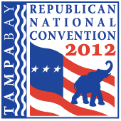
The 2012 Republican National Convention was a gathering held by the U.S. Republican Party during which delegates officially nominated former Massachusetts Governor Mitt Romney and Representative Paul Ryan of Wisconsin for president and vice president, respectively, for the 2012 election. Prominent members of the party delivered speeches and discussed the convention theme, "A Better Future." The convention was held during the week of August 27, 2012, in Tampa, Florida at the Tampa Bay Times Forum. The city, which expected demonstrations and possible vandalism, used a federal grant to bolster its police force in preparation. Due to the approach of Hurricane Isaac, convention officials changed the convention schedule on August 26, 2012; the convention came to order on August 27, 2012, and then immediately recessed until the following afternoon because of the risk of Isaac hitting Tampa.

The 2012 United States presidential election was the 57th quadrennial presidential election, held on Tuesday, November 6, 2012. Incumbent Democratic President Barack Obama and his running mate, incumbent Vice President Joe Biden, were elected to a second term. They defeated the Republican ticket of former Governor of Massachusetts Mitt Romney and U.S. Representative Paul Ryan of Wisconsin.

Voters of the Republican Party elected state delegations to the 2012 Republican National Convention in presidential primaries. The national convention then selected its nominee to run for President of the United States in the 2012 presidential election. There were 2,286 delegates chosen, and a candidate needed to accumulate 1,144 delegate votes at the convention to win the nomination. The caucuses allocated delegates to the respective state delegations to the national convention, but the actual election of the delegates were, many times, at a later date. Delegates were elected in different ways that vary from state to state. They could be elected at local conventions, selected from slates submitted by the candidates, selected at committee meetings, or elected directly at the caucuses and primaries.

This article contains lists of notable candidates for the United States Republican Party's 2012 presidential nomination.

The 2012 presidential campaign of Mitt Romney officially began on June 2, 2011, when former Massachusetts Governor Mitt Romney formally announced his candidacy for the Republican Party nomination for President of the United States, at an event in Stratham, New Hampshire. Having previously run in the 2008 Republican primaries, this was Romney's second campaign for the presidency.

The 2012 United States presidential election in Oklahoma took place on November 6, 2012, as part of the 2012 United States presidential election in which all 50 states plus the District of Columbia participated. Voters chose seven electors to represent them in the Electoral College via a popular vote pitting incumbent Democratic President Barack Obama and his running mate, Vice President Joe Biden, against Republican challenger and former Massachusetts Governor Mitt Romney and his running mate, Congressman Paul Ryan. For the third election in a row since 2004, no third parties were allowed on the ballot.

The 2012 United States presidential election in Pennsylvania took place on November 6, 2012, as part of the 2012 United States presidential election in which all 50 states plus the District of Columbia participated. The primary election to select the Democratic and Republican candidates had been held on April 24, 2012. Pennsylvania voters chose 20 electors to represent them in the Electoral College via a popular vote pitting incumbent Democratic President Barack Obama and his running mate, Vice President Joe Biden, against Republican challenger and former Massachusetts Governor Mitt Romney and his running mate, Congressman Paul Ryan. Pennsylvania's electoral vote number was a reduction from the 2008 delegation, which had 21 electors. This change was due to reapportionment following the 2010 United States Census. Pennsylvania's 20 electoral votes are allotted on a winner-take-all basis.

The 2012 United States presidential election in Tennessee was held on November 6, 2012, as part of the 2012 United States presidential election in which all 50 states plus the District of Columbia participated. Tennessee voters chose 11 electors to represent them in the Electoral College via a popular vote pitting incumbent Democratic President Barack Obama and his running mate, Vice President Joe Biden, against Republican challenger and former Massachusetts Governor Mitt Romney and his running mate, Congressman Paul Ryan.

The 2012 United States presidential election in Texas took place on November 6, 2012, as part of the 2012 United States presidential election in which all 50 states plus the District of Columbia participated. Texas voters chose 38 electors to represent them in the Electoral College via a popular vote pitting incumbent Democratic President Barack Obama and his running mate, Vice President Joe Biden, against Republican challenger and former Massachusetts Governor Mitt Romney and his running mate, Congressman Paul Ryan.

On May 29, 2012, former Governor Mitt Romney of Massachusetts won the 2012 nomination by the Republican Party for President of the United States, and became the presumptive nominee of the party. On August 11, 2012, Romney officially announced his selection of Wisconsin Representative Paul Ryan as his running mate to supporters via an iPhone app, though the selection of Ryan had already leaked to the press hours before the official announcement. Ryan was the first individual from Wisconsin to appear on a national ticket of a major party as a nominee either for President or Vice President of the United States, although third-party presidential candidate Robert M. La Follette won 16% of the popular vote in the 1924 election. The Romney–Ryan ticket ultimately lost to the Obama–Biden ticket in the 2012 presidential election.

The 2016 United States presidential election in North Carolina held on Tuesday, November 8, 2016, as part of the 2016 United States presidential election in which all 50 states plus the District of Columbia participated. North Carolina voters chose electors to represent them in the Electoral College via a popular vote, pitting the Republican Party's nominee, businessman Donald Trump, and running mate Indiana Governor Mike Pence against Democratic Party nominee, former Secretary of State Hillary Clinton, and her running mate Virginia Senator Tim Kaine. North Carolina had 15 electoral votes in the Electoral College.


