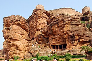
Badami, formerly known as Vātāpi, is a town and headquarters of a taluk by the same name, in the Bagalkot district of Karnataka, India. It was the regal capital of the Badami Chalukyas from 540 to 757. It is famous for its rock cut monuments such as the Badami cave temples, as well as the structural temples such as the Bhutanatha temples, Badami Shivalaya and Jambulingesvara Temple. It is located in a ravine at the foot of a rugged, red sandstone outcrop that surrounds Agastya lake.
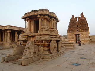
Koppala district, officially known as Koppala district is an administrative district in the state of Karnataka in India. In the past Koppal was referred to as 'Kopana Nagara'. Hampi, a World heritage center, covers some areas of Koppala District. It is situated approximately 38 km away. Anegundi, is also a famous travel destination.

Trikuteshwara temple is a Hindu temple dedicated to Shiva. The carved temple is in the town of Gadag, 50 km southeast of Hubli-Dharwad, in Karnataka, India. It is dedicated to Shiva and has three lingas mounted on the same stone. There is a shrine dedicated to Saraswathi in this temple and it has carved columns.

Gadag district is a district in the state of Karnataka, India. It was formed in 1997, when it was split from Dharwad district. As of 2011, it had a population of 1064570. The overall population increased by 13.14 percent from 1991 to 2001. Gadag district borders Bagalkot district on the north, Koppal district on the east, Vijayanagara district on the southeast, Haveri district on the southwest, Dharwad district on the west and Belgaum District on the northwest. It is famous for the many monuments from the Western Chalukya Empire. It has seven talukas: Gadag, Gajendragad, Ron, Shirhatti, Nargund, Lakshmeshwar and Mundargi.

Lakkundi, also referred to as Lokkugundi, was a major city before the 14th century, and is now a village in Gadag District of Karnataka, India. By 10th century, it was already a major economic and commerce center with mint operations for South India, one mentioned in Kannada and Sanskrit inscriptions and texts. By 12th century, many Hindu and Jain temples had been consecrated here, along with public infrastructure such as stepwells and water reservoirs. Among the major temples are the Brahma Jinalaya (oldest), Mallikarjuna, Lakshminarayana, Manikeshwara, Naganatha, Kumbheshvara, Nanneshwara, Someshwara, Narayana, Nilakanteshwara, Kasivisesvara, Virabhadhara, Virupaksha, and others. As its importance and wealth grew, Lakkundi became one of the capitals of the Hoysala Empire.

North Karnataka is a geographical region in Deccan plateau from 300 to 730 metres elevation that constitutes the region of the Karnataka state in India and the region consists of 14 districts. It is drained by the Krishna River and its tributaries the Bhima, Ghataprabha, Malaprabha, and Tungabhadra. North Karnataka lies within the Deccan thorn scrub forests ecoregion, which extends north into eastern Maharashtra.

Annigeri is a taluk of Dharwad district in the state of Karnataka, India, located 20 km west of Gadag en route to Hubli and 35 km from Hubli.

Basavakalyana is a historical city and municipal council in the Bidar District of the Indian state of Karnataka. It was the capital of two dynasties—Kalyani Chalukya and Kalachuris of Kalyani. It is famous for the world's tallest Basavanna statue, which stands 108 feet high. It is one of the major cities and industrial hubs of Bidar district.

Gajendragad is a Town Municipal Council city in Gadag District, Karnataka, India with Population of 32,359 as of 2011 Census data. It has an average elevation of 643 metres (2109 feet). It is about 55 kilometers from the district head quarter Gadag, 110 kilometers from Hubli, 200 kilometers from Belgaum and 450 kilometers from state capital Bangalore

Karnataka, the sixth largest state in India, was ranked as the third most popular state in the country for tourism in 2014. It is home to 507 of the 3600 centrally protected monuments in India, second only to Uttar Pradesh. The State Directorate of Archaeology and Museums protects an additional 752 monuments and another 25,000 monuments are yet to receive protection.

Banashankari Devi Temple is a Hindu shrine located at Cholachagudda near Badami, in Bagalkot district, Karnataka, India. The temple is popularly called 'Shakambhari' 'Banashankari or Vanashankari' since it is located in the Tilakaaranya forest. The temple deity is also called the Shakambhari, an incarnation of the goddess Parvati.
Cholachagudda is in Bagalkot District Karnataka State of India, it is near Badami. It is on the bank of Malaprabha river which is a tributary of Krishna river. It has two famous Hindu temples dedicated to Banashankari and Virabadhreshwara. It is known for its paan leaves plantation, clove-chillies and banana plantations.

Sudi, is a panchayat town in the Gadag District of Karnataka, India. It is about 30 km from Badami, 12 km from Gajendragad and 3 km from Itagi Bhimambika temple. In the past it was an important town of the Kalyani Chalukyas during 1000 AD. It is notable for rare stone carved monuments like Twin towered temple, Mallikarjuna temple and nagakunda , and few other structural temples. For long time these structures were abandoned, but recently they caught the eye of the Indian Archaeological Department.

The Mahakuta group of temples is located in Mahakuta, a village in the Bagalkot district of Karnataka state, India. It is an important place of worship for Hindus and the location of a well-known Shaiva monastery. The temples are dated to the 6th or 7th century CE and were constructed by the early kings of the Chalukya dynasty of Badami. The dating of the temples is based on the style of architecture which is similar to that of the temples in nearby Aihole and the information in two notable inscriptions in the complex: the Mahakuta Pillar inscription dated between 595–602 CE ; and an inscription of Vinapoti, a concubine of king Vijayaditya, dated between 696–733 CE and written in the Kannada language and script.

Temples of North Karnataka

Bhimambika temple or Bheemavva temple, is a popular Mutt and temple located in the temple town of Itagi in Gadag District, Ron Taluk in Karnataka. It is About 13 km from Gajendragad Kalkaleshwara temple.
Belavanaki is a village in southern state of Karnataka, India. It is located in Ron Taluka of Gadag district in Karnataka. It belongs to Belagavi Division.
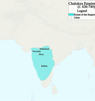
The Chalukya dynasty was a Classical Indian dynasty that ruled large parts of southern and central India between the 6th and the 12th centuries. During this period, they ruled as three related yet individual dynasties. The earliest dynasty, known as the "Badami Chalukyas", ruled from Vatapi from the middle of the 6th century. The Badami Chalukyas began to assert their independence at the decline of the Kadamba kingdom of Banavasi and rapidly rose to prominence during the reign of Pulakeshin II. After the death of Pulakeshin II, the Eastern Chalukyas became an independent kingdom in the eastern Deccan. They ruled from Vengi until about the 11th century. In the western Deccan, the rise of the Rashtrakutas in the middle of the 8th century eclipsed the Chalukyas of Badami before being revived by their descendants, the Western Chalukyas, in the late 10th century. These Western Chalukyas ruled from Kalyani until the end of the 12th century.

The following outline is provided as an overview of and topical guide to Karnataka:


