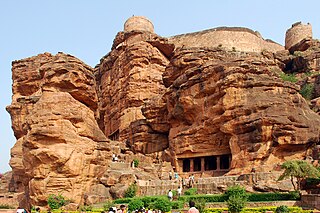
Belavanaki

Last updated

Belavanaki
Bolunki
Village
Belavanki
Coordinates: 12°58′41″N77°34′08″E / 12.9779204°N 77.5687766°E / 12.9779204; 77.5687766 Coordinates: 12°58′41″N77°34′08″E / 12.9779204°N 77.5687766°E / 12.9779204; 77.5687766
CountryFlag of India.svg  India
State Karnataka
District Gadag
Founded byGanga subordinate Bhutayya was the ruler of Belvola-300 in A.D 942
Named for Belavalanaadu-300
Talukas Ron
Government
  TypeGram panchayat
  BodyBelavanaki Gram Panchayat
Population
 (2001)
  Total5,118
Demonym Belavanakiyava
Languages
  Official Kannada
Time zone UTC+5:30 (IST)
Area code 08381
Vehicle registration KA26
Nearest cityHubballi and Gadag
Literacy71.41%
Climate Climatic regions of India (Köppen)
Rayara Temple in Belavanaki Rayar temple.jpg
Rayara Temple in Belavanaki

Belavanaki is a village in southern state of Karnataka, India. It is located in Ron Taluka of Gadag district in Karnataka. It belongs to Belagavi Division.

Contents

Location

It is located:

Profile

History and origin of the village name

According to the Ron inscription introduces the Ganga subordinate Mahamandalika Butayya as the governor of Gangavadi-96,000, Belvola-300, Puligere-300 provinces in Saka 864 (A..D. 942) while his Kurtakoti inscription mentions the chief as holding charge of the same provinces in Saka 868 (A.D. 946) therefore scriptures of Rastrakuta and Chalukyas of Kalyana dynasties shows the existence of this village goes back to ninth and 10th century and it is also ruled by Maratha king Shivaji and Peshwas of 17th and 18th century. This village name may be derived from old name of ‘Belavala-nadu 300’(Deccan Plains) or Belvola-300 which means region consisting of 300 villages and also means fertile land.

People and village features

Saptamtrikas sculpture in Belavanaki (Near Veerabhadra Temple) Saptamatrika, "seven mothers": Brahmani, Vaishnavi, Maheshvari, Indrani, Kaumari, Varahi, Chamunda, and Narasimhi Sapta 2.jpg
Saptamtrikas sculpture in Belavanaki (Near Veerabhadra Temple) Saptamatrika, "seven mothers": Brahmani, Vaishnavi, Maheshvari, Indrani, Kaumari, Varahi, Chamunda, and Narasimhi

Here people used to call Bolunki, Bolunaki in their own dialect while speaking. Belavanaki is considered to be one of the most important village where its development is considered. Educational institutions, small scale industries like cotton mills, and its history goes back to British colonial period these mills are started by the local feudal land lords. Nevertheless, these mills work in season time and moreover attraction of these mills is old charm where monumental structure and buildings are at the epicentre of the village. This village generally connected with five roads including state highway, it made village like semi urban area because it has school, colleges, bank, film talkies, primary health centre, these urban like features attract peoples from all the villages which are surrounded with Belavanaki.and It is also a birthplace of S. R. Hiremath social activist and Founder President of Samaja Parivarthana Samudaya, National Committee for Protection of Natural Resources and India Development Service.

Culture and temples

In Belavanaki, the majority of the peoples are Hindu and Muslims therefore all festivals are here two religions centric but despite of their different religious faith both they celebrate almost all the festivals, this shows us the village cultural heritage and harmony among the two religion. Local attractions are:

Belavanaki Bus stand Belavanaki Bus stand.jpg
Belavanaki Bus stand

Here the newly carved statue of Veerabhadra which is considered to be best kind of sculpture in recent time in Karnataka, therefore people from various part of state use to come here to visit this temple.

Belavanaki Main Lake for Drinking water Belavanaki Main Lake.jpg
Belavanaki Main Lake for Drinking water

Youth and self help groups

Belavanaki is also not lacking behind for establishing organisations, co-operative societies, Self-help groups in the village. Here youth and peasant union are strong hold in raising issues of youths, farmers, women's, students in the Gram Sabha meeting.

Names of the youth and self-help groups in Belavanaki

Belavanaki Primary Health Center Belavanaki Primary Health Center.jpg
Belavanaki Primary Health Center

Education institutions

Demographics

As of 2001 India census, Belavanaki had a population of 5118 with 2642 males and 2476 females. [1]

The population of children age 0–6 is 533 which makes up 11.01% of total population of village. Average Sex Ratio of Belavanaki village is 945 which is lower than Karnataka state average of 973. Child Sex Ratio for the Belavanaki as per census is 864, lower than Karnataka average of 948. village has lower literacy rate compared to Karnataka. In 2011, literacy rate of Belavanaki village was 71.41% compared to 75.36% of Karnataka. In Belavanaki Male literacy stands at 81.74% while female literacy rate was 60.60%.

Transportation

Ron is the nearest town to Belavanaki. Ron is 19 km from Belavanaki. Road connectivity is there from Ron to Belavanaki.

Nearby railway stations are: Mallapur Railway station - 5 km; Balganur- 10 km; Somankatti- 14 km and Hombal- 18 km.

Airports

Places to visit

Nearby cities

Taluks

District headquarters

See also

Related Research Articles

<span class="mw-page-title-main">Badami</span> Town in Karnataka, India

Badami, formerly known as Vātāpi [Sanskrit: from āpi, ‘friend, ally’; ‘having the wind (vāta) as an ally’], is a town and headquarters of a taluk by the same name, in the Bagalkot district of Karnataka, India. It was the regal capital of the Badami Chalukyas from 540 to 757. It is famous for its rock cut monuments such as the Badami cave temples, as well as the structural temples such as the Bhutanatha temples, Badami Shivalaya and Jambulingesvara Temple. It is located in a ravine at the foot of a rugged, red sandstone outcrop that surrounds Agastya lake.

<span class="mw-page-title-main">Belagavi district</span> District of Karnataka in India

Belagavi district, formerly known as also Belgaum district, is a district in the state of Karnataka, India. The district is known as Sugar Bowl of Karnataka with 1.5 lakh (150,000) hectares being used for commercial production and it has displaced Mandya district in sugar cane production over the last decade. The city of Belagavi is the district headquarters in North Karnataka. It houses the second legislative building, where the Karnataka Legislature will meet once a year. A popular sweet is kunda. According to the 2011 Census of India, it has a population of 4,779,661, of which 24.03% live in urban areas, making it the second most populous district in Karnataka, after Bangalore. The district has an area of 13,415 km2 (5,180 sq mi) making it the largest district in Karnataka, and is bounded by Kolhapur District and Sangli district of Maharashtra state on the west and north, on the northeast by Bijapur district, on the east by Bagalkot district, on the southeast by Gadag district, on the south by Dharwad and Uttara Kannada districts, and on the southwest by the state of Goa.

Bailhongal is a Taluk in Belagavi district of Karnataka state in southern India. Bailhongal Taluk is located towards the north-east part of Belagavi. The taluk headquarters is about 44 km from the district headquarters. The total geographical area of the taluk is 1122.40 km2. There are 126 revenue villages and 14 hamlets with a total population of 356,400 people, according to the 2001 census.

<span class="mw-page-title-main">Gadag district</span> District of Karnataka in India

Gadag is a district in the state of Karnataka, India. It was formed in 1997, when it was split from Dharwad district. As of 2011, it had a population of 1064570. The overall population increased by 13.14 percent from 1991 to 2001. Gadag district borders Bagalkot district on the north, Koppal district on the east, Vijayanagara district on the southeast, Haveri district on the southwest, Dharwad district on the west and Belgaum District on the northwest. It is famous for the many monuments from the Western Chalukya Empire. It has seven talukas: Gadag, Gajendragad, Ron, Shirhatti, Nargund, Lakshmeshwar and Mundargi.

<span class="mw-page-title-main">North Karnataka</span> Region in Karnataka, India

North Karnataka is a geographical region in Deccan plateau from 300 to 730 metres elevation that constitutes the region of the Karnataka state in India and the region consists of 13 districts. It is drained by the Krishna River and its tributaries the Bhima, Ghataprabha, Malaprabha, and Tungabhadra. North Karnataka lies within the Deccan thorn scrub forests ecoregion, which extends north into eastern Maharashtra.

<span class="mw-page-title-main">Dharwad district</span> District of Karnataka in India

Dharwad is an administrative district of the state of Karnataka in southern India. The administrative headquarters of the district is the city of Dharwad, also known as Dharwar. Dharwad is located 425 km northwest of Bangalore and 421 km southeast of Pune, on the main highway between Chennai and Pune, the National Highway 4 (NH4).

Kaladgi is a panchayat village in the Bagalkot Taluk, Bagalkot District of Karnataka State and is located about 25 km by road west of the town of Bagalkot. Kaladgi is well known for its fruit gardens.

<span class="mw-page-title-main">Gajendragad</span> Town and Taluk in Karnataka, India

Gajendragad is a town and a sub-district place in Gadag District, Karnataka, India. This place is known for its hill station and hill strip. Highest populated city after Gadag in the district. It is about 55 kilometers from the district head quarter Gadag, 110 kilometers from Hubballi, 200 kilometers from Belagavi and 450 kilometers from state capital Bengaluru.

Harapanahalli is a city and sub-divisional headquarter of Harapanahalli, HuvinaHadagali, and Kotturu Taluks; and the headquarter of Harapanahalli taluk in the Vijayanagara district. it is the second largest and fastest growing city/town in the Vijayanagara district in the Indian state of Karnataka. The famous Kannada humorist "Beechi" was born here. the place which connects Kalyana Karnataka with Middle Karnataka, Harapanahalli have a very frequent transport connectivity, water facility and a good education from Pre KG to Master's and it was the main revenue, trading and educational center since from Madras Presidency.

<span class="mw-page-title-main">Lakshmeshwara</span> Town/Taluk in Karnataka, India

Lakshmeshwara is a town, and newly created Taluk place along with Gajendragad in Gadag district, in the Indian state of Karnataka. It is about 40 km from Gadag and 55 km from Hubli. It is an agricultural trading town. Lakshmeshwara Temple dedicated to Shiva. There are many important temples in this historic town, including the other Shiva temple, the Someshwara Temple. There are two ancient Jain temples in the town, as well as a notable Jamma Masjid. Lakshmeshwara is also home for many smaller shrines, a dargah, the Kodiyellamma temple, the Mukha Basavanna shrine, and a gigantic idol of Suryanarayana.

Ron is a taluka headquarters in Gadag district, Karnataka in India. Of historical importance, the town was termed Dronapur in ancient times. The temples are believed to be constructed by the ancient architect and warrior-priest Dronacharya.

Shiggaavi is a municipal town in Haveri district in the Indian state of Karnataka.

<span class="mw-page-title-main">Sudi, India</span> Panchayat town in Karnataka, India

Sudi, is a panchayat town in the Gadag District of Karnataka, India. It is about 30 km from Badami, 12 km from Gajendragad and 3 km from Itagi Bhimambika temple. In the past it was an important town of the Kalyani Chalukyas during 1000 AD. It is notable for rare stone carved monuments like Twin towered temple, Mallikarjuna temple and nagakunda , and few other structural temples. For long time these structures were abandoned, but recently they caught the eye of the Indian Archaeological Department.

<span class="mw-page-title-main">Kuknur</span> Town in Karnataka, India

Kuknoor is a town in Kukanoor taluk in the Koppal District of the Indian state of Karnataka, which is located about 40 km northwest of Hospet and 7 km from the Mahadeva Temple in Itagi. Kuknoor is known for the temples of the Rashtrakutas and Chalukyas in the town, with the most notable being the Navalinga Temple.

Buddhism in Northern Karnataka has seen major development after the discovery of an Ashoka inscription at Maski in Raichur District a few decades ago and of a Buddhist settlement through a series of archaeological excavations at Sannati which have shed light on the historic significance of Karnataka.

Shegunashi is a village in the southern state of Karnataka, India. It is located in the Athani taluk of Belagavi district in Karnataka.

Shelawadi or Shelavadi is a panchayat town in the southern state of Karnataka, India. It is located in the Navalgund taluk of Dharwad district in Karnataka.

Hanamsagar, also spelled as Hanumasagara is a village in the Kushtagi taluk of Koppal district in Karnataka state, India.

<span class="mw-page-title-main">Outline of Karnataka</span> Overview of and topical guide to Karnataka

The following outline is provided as an overview of and topical guide to Karnataka:

References

  1. Village code= 620300 "Census of India : Villages with population 5000 & above". Registrar General & Census Commissioner, India. Archived from the original on 8 December 2008. Retrieved 18 December 2008.