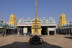
Kanakagiri Suvarnagiri | |
---|---|
town/taluk | |
Coordinates: 15°33′N76°24′E / 15.550°N 76.400°E | |
Country | India |
State | Karnataka |
District | Koppal |
Population | |
• Total | 22,098 |
Languages | |
• Official | Kannada |
Time zone | UTC+5:30 (IST) |
PIN | 583283 |
ISO 3166 code | IN-KA |
Vehicle registration | KA 37 |
Nearest city | Gangavathi |
Lok Sabha constituency | Koppal |
Vidhan Sabha constituency | Kanakagiri |
Website | www |
Kanakagiri (also known as Suvarnagiri) is a town in Karnataka state of India. It was a provincial capital of the Mauryan Empire and later became the capital of the Nayaka dynasty who were the Palegars (feudatory) of the Vijayanagara Empire. [1] [2] It is also the site of the historical site Kanakachalapathi Temple (Kanakachalapathi Mandir) which was built by the Nayakas. [1]
Kanakagiri is situated in Koppal district, 20 km northwest of the town of Gangavati in the Indian state of Karnataka. [3]
Kanakachalapathi temple was built by the Nayakas of Kanakgiri. [4] Its halls and pillars are a unique example of south Indian architecture from the Vijayanagara period. The gopuras and walls are adorned with sculptures, including statues of Rajas and Ranis in black polished stone, plaster models, and wooden statues of mythological figures.
Kanakagiri Jain tirth is a complex of Jain temple built by Western Ganga Dynasty in the 5th or 6th century.
A royal bath constructed by Raja Venkatappa Nayaka in 1586 sits on the outskirts of Kanakgiri. [2]
The Hemagudda Fort, about 20 km from Kanakagiri [5] is next to the Kammatadurga Fort of Gandugali Kumara Rama. The fort was constructed in the 14th century. The fort has a temple of Durga Devi celebrating Dasara.
Kanakagiri Utsav is an annual fair associated with the Kanakachalapathi temple during Phalguna. [4]
Photo Gallery |
---|
|
The history of southern India covers a span of over four thousand years during which the region saw the rise and fall of a number of dynasties and empires.
Raichur District is an administrative district in the Indian state of Karnataka. It is located in the northeast part of the state and is bounded by Yadgir district in the north, Bijapur and Bagalkot district in the northwest, Koppal district in the west, Bellary district in the south, Jogulamba Gadwal district of Telangana and Kurnool district of Andhra Pradesh in the east.
Koppala district, officially known as Koppala district is an administrative district in the state of Karnataka in India. In the past Koppal was referred to as 'Kopana Nagara'. Hampi, a World heritage center, covers some areas of Koppala District. It is situated approximately 38 km away. Anegundi, is also a famous travel destination.
Chandragiri is a suburb and neighbourhood of Tirupati and located in Tirupati district of the Indian state of Andhra Pradesh. It is a part of Tirupati urban agglomeration and a major growing residential area in Tirupati It is the mandal headquarters of Chandragiri mandal in Tirupati revenue division. It also falls in the jurisdictional limit of Tirupati Urban Development Authority. Chandragiri is the southwestern entrance of Tirupati for vehicles coming from Bangalore, Kerala and Tamil Nadu. Kalyana Venkateswara Temple, Srinivasamangapuram is located next to Chandragiri through which well-laid stone footpaths called Srivari Mettu are available to reach Tirumala on foot.
Humcha / Hombuja is a small town near Ripponpet, Hosanagara taluk in Shimoga district in the Indian state of Karnataka. Humbaja Atishaya Jain Teerth Kshetra is famous for being home to an ancient temple of Goddess Padmavati, and to the Humbaj Matha (seminary/monastery), an important institution of the Jain community. This temple is considered to be very holy and is known for its cultural and historical heritage. Other notable highlights of the place are a lake that reputedly never dries up and a tree that likewise always remains green.
North Karnataka is a geographical region in Deccan plateau from 300 to 730 metres elevation that constitutes the region of the Karnataka state in India and the region consists of 13 districts. It is drained by the Krishna River and its tributaries the Bhima, Ghataprabha, Malaprabha, and Tungabhadra. North Karnataka lies within the Deccan thorn scrub forests ecoregion, which extends north into eastern Maharashtra.
Raichur is a city and headquarters of eponymous Raichur district in the Karnataka state of India. Raichur, located between Krishna and Tungabhadra rivers.
Koppal is the district headquarters of Koppal district in the Indian state of Karnataka. Koppal is surrounded on three sides by hills. It was known as Kopana Nagara. The town has historical landmarks such as the Koppal Fort, Gavimath, and the Male Mallappa Temple. Historically, Koppal was known as Jaina Kashi, meaning the "Kashi" or most-sacred-place for Jains. It was so named because there were more than 700 Basadis, Jain meditation halls or Prarthana Mandirs. Koppal district was carved out of Raichur district, located in the northern part of Karnataka state, on 1 April 1998.
Nayakas of Keladi (1499–1763), also known as Nayakas of Bednore and Ikkeri Nayakas, were an Indian dynasty based in Keladi in present-day Shimoga district of Karnataka, India. They were an important ruling dynasty in post-medieval Karnataka. They initially ruled as a vassal of the famous Vijayanagar Empire. After the fall of the empire in 1565, they gained independence and ruled significant parts of Malnad region of the Western Ghats in present-day Karnataka, most areas in the coastal regions of Karnataka and the central plains along the Tungabhadra river. In 1763 AD, with their defeat to Hyder Ali, they were absorbed into the Kingdom of Mysore. They played an important part in the history of Karnataka, during a time of confusion and fragmentation that generally prevailed in South India after the fall of the Vijayanagar Empire. The Keladi rulers were of the Vokkaliga and Banajiga castes and were Veerashaivas by faith. The Haleri Kingdom that ruled over Coorg between 1600 A.D and 1834 A.D. was founded by a member of the Keladi family.
Barkur is an area in the Brahmavara taluk, Udupi district of Karnataka state in India, comprising three villages, Hosala, Hanehalli, and Kachoor. The area is located on the bank of River Seetha. It is also referred to as a "temple town".
Dravidian architecture, or the Southern Indian temple style, is an architectural idiom in Hindu temple architecture that emerged from Southern India, reaching its final form by the sixteenth century.
Karnataka, the sixth largest state in India, has been ranked as the third most popular state in the country for tourism in 2014. It is home to 507 of the 3600 centrally protected monuments in India, second only to Uttar Pradesh. The State Directorate of Archaeology and Museums protects an additional 752 monuments and another 25,000 monuments are yet to receive protection.
Karnataka, a state in South India has a long association with Jainism, a religion which enjoyed patronage of major historic kingdoms in the state such as the Rastrakuta Dynasty, Western Ganga, Kadamba and Chalukya dynasties and the Hoysala Empire. Today the state is home to a number of Jain monuments, such as temples, Gommata statues and stambhas.
Temples of North Karnataka
The antiquity of architecture of Karnataka can be traced to its southern Neolithic and early Iron Age, Having witnessed the architectural ideological and utilitarian transformation from shelter- ritual- religion. Here the nomenclature 'Architecture' is as old as c.2000 B.C.E. The upper or late Neolithic people in order to make their shelters by their own they constructed huts made of wattle and doab, that were buttressed by stone boulders, presumably having conical roof resting on the bamboo or wooden posts into red murram or paved granite chips as revealed in archaeological excavations in sites like Brhamagiri, Sanganakallu, Tekkalakota, Piklihal. Megaliths are the dominant archaeological evidence of the early Iron Age. There are more than 2000 early Iron Age burial sites on record, who laid the foundation for a high non-perishable architecture in the form of various distinct architectural styles of stone-built burials, which are ritualistic in its character. The active religious architecture is evident 345 with that of the Kadamba Dynasty. Karnataka is a state in the southern part of India originally known as the State of Mysore. Over the centuries, architectural monuments within the region displayed a diversity of influences, often relaying much about the artistic trends of the rulers of twelve different dynasties. Its architecture ranges dramatically from majestic monolith, such as the Gomateshwara, to Hindu and Jain places of worship, ruins of ancient cities, mausoleums and palaces of different architectural hue. Mysore Kingdom (Wodeyar) rule has also given an architectural master structure in the St. Philomena's Church at Mysore which was completed in 1956, in addition to many Dravidian style architectural temples. Two of the monuments are listed under the UNESCO World Heritage List of 22 cultural monuments in India. Styles of Indo-Saracenic, Renaissance, Corinthian, Hindu, Indo-Greek and Indo-British style palaces were built in Mysore, the city of palaces. Sikh architecture at Bidar (1512) and also in Bangalore in 1956 can also be cited as having an impact on the architectural composition of the state.
The name Karnataka is derived from Karunadu, meaning 'lofty land' or 'high plateau', due to its location on the Deccan Plateau. The name can also mean 'land of black soil' in Kannada. There are other possible roots of the name. The recorded history of Karnataka goes back to the Ramayana and Mahabharata epics. The capital of "Vaali" and "Sugriva" referenced in the Ramayana is said to be Hampi. Karnataka is mentioned in the Mahabharata as "Karnata Desha"." Historically, the region was also called "Kuntala Rajya".
The following outline is provided as an overview of and topical guide to Karnataka:
The Kanakachalapathi temple is a 16th-century Hindu temple dedicated to the god Vishnu. It is located in the town of Kanakagiri, in the Gangavathi taluk of Koppal district in the Karnataka state, India. Kanakagiri, known in ancient times as "Swarnagiri" is about 3 km from the district headquarters Koppal city, 380 km north of Bangalore city and 200 km east of Belagavi city.
Kanakagiri Jain tirth kshetra also known as Kanakadri and Hemantha Desha is situated at about 3 km from Maleyuru, Chamarajanagar district, 53 km from the Mysore city and 182 km from Bengaluru.
Arikadi Fort is a fort located in the Kasaragod district of Kerala, India. It is also known as Kumbla Fort. The fort is located at a distance of 1 km from Kumbla on the NH 66 National Highway between kumbala River and shiriya River There is a Hanuman temple just below the fort.