
Bijapur, officially known as Vijayapura, is the district headquarters of Bijapur District of Karnataka state of India. It is also the headquarters for Bijapur Taluka. Bijapur city is well known for its historical monuments of architectural importance built during the rule of the Adil Shahi dynasty. It is also well known for the sports by the popular Karnataka premier league team as Bijapur Bulls. Bijapur is located 530 km (330 mi) northwest of the State Capital Bangalore and about 550 km (340 mi) from Mumbai and 384 km (239 mi) west of the city of Hyderabad.

Haveri is a district in the state of Karnataka, India with the potential to become a tourist hub. As of 2011, it had a population of 1,597,668 of which 20.78% were urban residents.
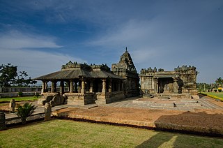
Gadag District is a district in the state of Karnataka, India. It was formed in 1997, when it was split from Dharwad District. As of 2011, it had a population of 1064570. The overall population increased by 13.14 percent from 1991 to 2001. Gadag District borders Bagalkot District on the north, Koppal District on the east, Bellary District on the southeast, Haveri District on the southwest, Dharwad District on the west and Belgaum District on the northwest. It features monuments from the Western Chalukya Empire. It has seven talukas/ tehsils: Gadag, Gajendragad,, Ron, Shirhatti, Nargund, Lakshmeshwar and Mundargi.

Sirsi is a town and hilly region of Uttara Kannada district in Indian state of Karnataka. Sirsi was also known as Kalyanapattana during the Sonda Dynasty. Sirsi is also known as "Gate way of Malenadu" or "Gateway of Western Ghats".

North Karnataka is a geographical region in Deccan plateau from 300 to 730 metres elevation that constitutes the northern part of the Karnataka state in India. It is drained by the Krishna River and its tributaries the Bhima, Ghataprabha, Malaprabha, and Tungabhadra. North Karnataka lies within the Deccan thorn scrub forests ecoregion, which extends north into eastern Maharashtra. Most parts of the region has black fertile soil ideal for agriculture.

Dharwad is an administrative district of the state of Karnataka in southern India and is the cultural headquarters of North Karnataka.

Haveri is a City in Karnataka, India, It is the administrative headquarters of Haveri District. The name Haveri is derived from the Kannada words haavu and keri, which means place of snakes. Haveri is famous for its cardamom garlands. It is said that Haveri had around 1000 mathas in ancient days. One of the famous mathas is Hukkeri Math. Haveri is also famous for marketing Byadagi red chillies, which are well known all over India. Around 25 km away, there is a place called Bada which is the birthplace of the poet Kanakadasa.

Bankapura is a panchayat town in Haveri district in the state of Karnataka, India. It is in Shiggaon taluk, is just 2.5 km from the Pune-Bangalore national highway NH-4, 22 km from Haveri town. Bankapura is about 45 km from Hubli-Dharwad. An historical site, Bankapura is famous for the Nagareshwara temple, Bankapura fort, The Bankapura Peacock Sanctuary. Baada, the birthplace of Kanakadasa is near to Bankapura.
Lingasugur is a municipal town in Raichur district in the Indian state of Karnataka. There are many Temples, hills and forts (Quila). The festivals of Muharram and Maha Shivaratri are important here. Mudgal in Lingasugur taluk has a very ancient fort. It has often been mentioned in the autobiography of Philip Meadows Taylor. Lingasugur, then known as Chavani was the site of a major British cantonment in the region.
Shiggaon, also known as Shiggavi, is a Municipal Town in Haveri district in the Indian state of Karnataka.
Karnataka, the sixth largest state in India, has been ranked as the third most popular state in the country for tourism in 2014. It is home to 507 of the 3600 centrally protected monuments in India, the largest number after Uttar Pradesh. The State Directorate of Archaeology and Museums protects an additional 752 monuments and another 25,000 monuments yet to receive protection. Tourism centres on the ancient sculptured temples, modern cities, the hill ranges, forests and beaches. Broadly, tourism in Karnataka can be divided into four geographical regions: North Karnataka, the Hill stations, Coastal Karnataka and South Karnataka.

Kuknoor is a city in Kukanoor taluk in the Koppal District of the Indian state of Karnataka, which is located about 40 km northwest of Hospet and 7 km from the Mahadeva Temple in Itagi. Kuknoor is known for the temples of the Rashtrakutas and Chalukyas in the town, with the most notable being the Navalinga Temple.
Gudgeri is a village in the Kundgol taluk of Dharwad district in the Indian state of Karnataka. It is located in the Kundgol taluk of Dharwad district in Karnataka.
Kalas is a village in the southern state of Karnataka, India. It is located in the Kundgol taluk of Dharwad district in Karnataka. This is the native place of Guru Govindabhatta, who is the guru of Santha Shishunal Sharif. Today we can find Samadhi of Guru Govindabhatta here. His aradhana takes place every year during summer.
Balehosur is a village in the Lakshmeshwar taluk of Gadag district in the Indian state of Karnataka.

Belavanaki is a village in southern state of Karnataka, India. It is located in Ron Taluka of Gadag district in Karnataka. It belongs to Belagavi Division.
Yadoga is a village in Uttar kannada district in the state of Karnataka, India.
Shishuvinahala also known as Shishunala is a village in Shiggaon taluk of Haveri district in the state of Karnataka, India
Aremallapur is a village in the southern state of Karnataka, India. It is located in the Ranebennur taluk of Haveri district in Karnataka.
Pamenahalli is a village in Harihara Taluk in Davangere District of Karnataka State, India. It comes under Sarathi Panchayath. It belongs to Bangalore Division. It is located 17 km towards west from District headquarters Davanagere. 298 km from State capital Bangalore.

