
Bijapur, officially known as Vijayapura, is the district headquarters of Bijapur district of Karnataka state of India. It is also the headquarters for Bijapur Taluka. Bijapur city is well known for its historical monuments of architectural importance built during the rule of the Adil Shahi dynasty. It is also well known for the sports by the popular Karnataka premier league team as Bijapur Bulls. Bijapur is located 530 km (330 mi) northwest of the state capital Bangalore and about 550 km (340 mi) from Mumbai and 384 km (239 mi) west of the city of Hyderabad.

Raichur District is an administrative district in the Indian state of Karnataka. It is located in the northeast part of the state and is bounded by Yadgir district in the north, Bijapur and Bagalkot district in the northwest, Koppal district in the west, Bellary district in the south, Mahabubnagar district of Telangana and Kurnool district of Andhra Pradesh in the east.

Bijapur district, officially known as Vijayapura district, is a district in the state of Karnataka in India. The city of Bijapur is the headquarters of the district, and is located 530 km northwest of Bangalore. Bijapur is well known for the great monuments of historical importance built during the Adil Shahi dynasty.

Karnatak University is a state university in Dharwad district, in the state of Karnataka in India. It was established in October 1949 and officially inaugurated in March 1950. The campus spans 888 acres (3 km²). D. C. Pavate was the first official vice-chancellor from 1954 to 1967. The rapid development of the institution is credited to him.
The State Government of Karnataka is a democratically elected body with the governor as the constitutional head. The governor who is appointed for five years appoints the chief minister and on the advice of the chief minister appoints his council of ministers. Even though the governor remains the ceremonial head of the state, the day-to-day running of the government is taken care of by the chief minister and his council of ministers in whom a great amount of legislative powers are vested.
Bayaluseeme or Bayalu Seeme is the area lying to the east of Malenadu, a region of Karnataka state in India. The area is largely open plain, with few hillocks. It includes the districts of Bangalore, Bagalkot, Bijapur, Chitradurga, Davanagere, Dharwad, Gadag, Hassan, Haveri, Mandya, Mysore, Tumkur.

North Karnataka is a geographical region in Deccan plateau from 300 to 730 metres elevation that constitutes the northern part of the Karnataka state in India. It is drained by the Krishna River and its tributaries the Bhima, Ghataprabha, Malaprabha, and Tungabhadra. North Karnataka lies within the Deccan thorn scrub forests ecoregion, which extends north into eastern Maharashtra. Most parts of the region has black fertile soil ideal for agriculture.
Karnataka, the sixth largest state in India, has been ranked as the third most popular state in the country for tourism in 2014. It is home to 507 of the 3600 centrally protected monuments in India, the largest number after Uttar Pradesh. The State Directorate of Archaeology and Museums protects an additional 752 monuments and another 25,000 monuments yet to receive protection. Tourism centres on the ancient sculptured temples, modern cities, the hill ranges, forests and beaches. Broadly, tourism in Karnataka can be divided into four geographical regions: North Karnataka, the Hill stations, Coastal Karnataka and South Karnataka.

The state of Karnataka in India has a bittersweet relationship with rains. While its regions of Malnad and Coastal Karnataka receive copious amount of rainfall; its north Bayaluseemae region in the Deccan Plateau is one of the most arid regions in the country. Most of the rains received in the state is during the monsoon season. Being an agrarian economy with a large percentage of its citizens engaged in agriculture, the failure of rains can have a crippling effect on the economy of the state. Apart from the benefits in agriculture, the Government of Karnataka has tried to avail other benefits of rainfall using scientific methods. An example of this is the project, Rainwater Harvesting in Rural Karnataka which is initiated by the Karnataka State Council for Science and Technology and is one of the largest rainwater harvesting projects in the world. Agumbe in the Shimoga district, Amagaon in Belgaum District, Hulikal again in Shimoga district and Talakaveri in Madikeri are some of the known places with the highest annual rainfall in South India. Of this Amagaon has received over 10000 mm rain fall twice in 10 years.

Abbanakuppe is a village in the southern state of Karnataka, India. It is located in the Gubbi taluk of Tumkur district.
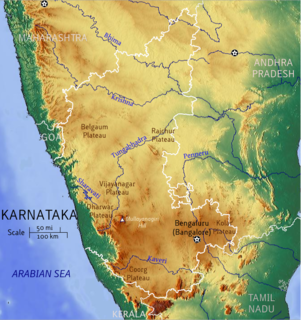
Karnataka is a state in the southern part of India. It was created on 1 November 1956, with the passing of the States Reorganisation Act. Karnataka is bordered by the Arabian Sea to the west, Goa to the north-west, Maharashtra to the north, Telangana and Andhra Pradesh to the east, Tamil Nadu to the south-east, and Kerala to the south-west. The state covers an area of 74,122 sq mi (191,976 km2), or 5.83% of the total geographical area of India. It comprises 30 districts. Kannada is the official language of Karnataka and is spoken by 65% of the population. Various ethnic groups with origins in other parts of India have unique customs and use languages at home other than Kannada, adding to the cultural diversity of the state. Other ethnic minorities in the state in 1991 were Urdu speakers (8%),Marathi people (7%),Telugu people (6%), Tamil people (3.8%), Tuluvas (3.38%), Hindi (1.87%), Konkani people (1.78%), Malayalis (1.69%), Kodavas (0.25%), and Gujarati people (0.10%).
Siddapur, Sidapur, Siddapura, or Sidapura are names of a number of towns, villages and administrative divisions in India. They include;

This article gives a list of the territories of the dioceses of the Catholic Church in India.

The following outline is provided as an overview of and topical guide to Karnataka:

Dharwad railway station is a major station under Hubli railway division of South Western Railway zone of Indian Railways situated in Dharwad constructed in the year of 1924, Karnataka.It is in top 10 station in SWR

Attur Nallur is a small village in Somwarpet Taluk in Kodagu District of Karnataka State, India. It comes under Attur Nallur Panchayath. It belongs to Mysore Division. It is located 12 km to the east of District headquarters Madikeri. 28 km from Somvarpet and 234 km from state capital Bangalore.
The Electricity Supply Companies, also known as ESCOMs, are responsible for electric power distribution in state of Karnataka. Its origin was in Karnataka Electricity Board. This distribution entity was incorporated to provide efficient and reliable electric power supply to the people of Karnataka state