Ronneby is regarded as the heart of "the Garden of Sweden", and in 2005 the park "Brunnsparken" in Ronneby was voted Sweden's most beautiful park. 2006 the park was voted Europe's 4th most beautiful park.[2] The church Heliga Kors kyrka was founded in the 12th century, modified and extended until the 15th century, and badly damaged during Northern Seven Years' War in the 16th century.
History
The city's oldest surviving city privileges are from 1387. The first recorded spelling of the name (around the year 1300) is Rotnæby, "the village upon the roaring (river)", so named because of the rapids on the spot. In the Middle Ages, Ronneby was an important trading and shipping town.
In 1564, Ronneby was the location of a bloody battle during the Northern Seven Years' War between the Swedish and the Danish armies during which the Swedes under King Erik XIV besieged the city, killed many inhabitants (Ronneby Bloodbath) and burnt it to the ground.[3] Erik later reported that "The Water was red from blood of the Danes." The number of victims was heavily exaggerated, for different propagandistic reasons, by both sides.[citation needed]
Following the Treaty of Roskilde in 1658, whereby Blekinge and other southern provinces became Swedish, a navy base was built in Karlskrona– east of Ronneby – which accordingly was granted city rights, while revoking the city rights of Ronneby.
But Ronneby did attract some industries in the 18th century. Besides the industry, it also hosted the Ronneby spa, with water believed to have healing qualities. The park around the spa can still be visited. The first source of chalybeate (ferruginous) water was found in May 1705. But the high period of the spa was in the 19th century.
After a fire in 1864, Ronneby was rebuilt according to a check pattern, which is still the model of today. Ronneby finally regained its city title in 1882. From 1971 it is the seat of the larger Ronneby Municipality.
In the 1970s, the local diving club discovered a shipwreck off the coast of Ronneby that was eventually identified by archaeologists as Gribshunden, a 15th-century Danishwarship.[4] The shipwreck is significant because it is the best-preserved and perhaps only known wreck of a carvel warship from the late medieval period. In addition, it served as the mobile castle for King Hans during the first decade of his reign, allowing him to project hard and soft power throughout his realm and beyond [5][6][7][8]
In December 2013, it was revealed that Ronneby's municipal water supply was highly contaminated with PFAS, also known as "forever chemicals," with testing showing the highest levels of PFAS ever recorded in municipal drinking water.[9]
Arms
Ronneby did use a coat of arms with the letter R between a star and a crescent at least since 1542. In 1882, the arms were redesigned, with the R substituted with the Ronnebyå River. The same coat of arms is used today by the municipality.
Images
Panorama of Ronneby
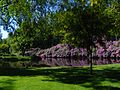
Rhododendron and lake in Brunnspark
Monks stairs with Heliga Kors kyrka in the background
Heliga Kors kyrka
Heliga Kors kyrka, window
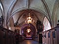
Heliga Kors kyrka, view to chorus
Heliga Kors kyrka, paintings
Heliga Kors kyrka, detail of paintings
Education
Knut Hahn Secondary School, a school aimed primarily at students in their late teens. It was completely renovated in 2004, at a cost of well over 100 million SEK (roughly US$16 million). It is funded and run by the Ronneby Municipality. It features most of the national programmes, teaching arts, science, industrial work and economics among many other subjects. It has about 700 students.
Ronneby also has many schools for lower ages, all run by the municipality save for a secondary school which is run by a company, called Skolalliansen.
Climate
Ronneby has an oceanic climate (Cfb), similar to most of Southern Sweden. The climate is very similar to neighbouring city Karlshamn, but has a somewhat higher rainfall and cooler nights throughout the year at the site located inside the premises of the local airport.
Climate data for Ronneby Airport 2002–2018; extremes since 1946
↑ Peterson, Gary Dean (2007): "Warrior Kings of Sweden. The Rise of an Empire in the Sixteenth and Seventeenth Centuries." McFarland. p.55ff.
↑ Einarsson, Av Lars. "Ett skeppsvrak i Ronneby skärgård"[A shipwreck in the archipelago of Ronneby](PDF) (in Swedish). Kalmar Läns Museum (Kalmar County Museum). Retrieved 2015-08-13.
This page is based on this Wikipedia article Text is available under the CC BY-SA 4.0 license; additional terms may apply. Images, videos and audio are available under their respective licenses.