Related Research Articles

The River Severn, at 220 miles (354 km) long, is the longest river in Great Britain. It is also the river with the most voluminous flow of water by far in all of England and Wales, with an average flow rate of 107 m3/s (3,800 cu ft/s) at Apperley, Gloucestershire. It rises in the Cambrian Mountains in mid Wales, at an altitude of 2,001 feet (610 m), on the Plynlimon massif, which lies close to the Ceredigion/Powys border near Llanidloes. The river then flows through Shropshire, Worcestershire and Gloucestershire. The county towns of Shrewsbury, Worcester and Gloucester lie on its course.

Shropshire is a ceremonial county in the West Midlands of England, on the Welsh border. It is bordered by Wrexham County Borough and Cheshire to the north, Staffordshire to the east, Worcestershire to the south-east, Herefordshire to the south and Powys to the west. The largest settlement is Telford, and Shrewsbury is the county town.

The Severn Valley Railway is a standard gauge heritage railway in Shropshire and Worcestershire, England, named after the company that originally built the railway over which it now operates. The 16-mile (26 km) heritage line runs from Bridgnorth to Kidderminster, following the course of the River Severn along the Severn Valley for much of its route, and crossing the river on the historic Victoria Bridge.

Chepstow is a town and community in Monmouthshire, Wales, adjoining the border with Gloucestershire, England. It is located on the tidal River Wye, about 2 miles (3 km) above its confluence with the River Severn, and adjoining the western end of the Severn Bridge. It is the easternmost settlement in Wales, situated 16 miles (26 km) east of Newport, 28 miles (45 km) east-northeast of Cardiff, 18 miles (29 km) northwest of Bristol and 110 miles (180 km) west of London.

Bewdley is a town and civil parish in the Wyre Forest District in Worcestershire, England on the banks of the River Severn. It is in the Severn Valley, and is 3 miles (4.8 km) west of Kidderminster, 10 miles (16 km) North of Worcester and 25 miles (40 km) southwest of Birmingham. It lies on the River Severn, at the gateway of the Wyre Forest national nature reserve, and at the time of the 2011 census had a population of 9,470. Bewdley is a popular tourist destination and is known for the Bewdley Bridge, designed by Thomas Telford, and the well preserved Georgian riverside.

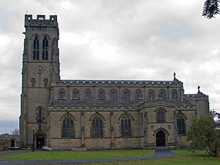
Bridgnorth is a town and civil parish in Shropshire, England. The River Severn splits it into High Town and Low Town, the upper town on the right bank and the lower on the left bank of the River Severn. The population at the 2011 Census was 12,079.

Alveley is a village in the Severn Valley in southeast Shropshire, England, about 11 miles (18 km) south-southeast of Bridgnorth. It is in the civil parish of Alveley and Romsley. The 2011 Census recorded the parish population as 2,098. It is served by bus service 297 operated by Select Bus Services. It is most famously known as being the hometown of Jack Jones, a local magician.

The Ironbridge Gorge is a deep gorge, containing the River Severn in Shropshire, England. It was first formed by a glacial overflow from the long drained away Lake Lapworth, at the end of the last ice age. The deep exposure of the rocks cut through by the gorge exposed commercial deposits of coal, iron ore, limestone and fireclay, which enabled the rapid economic development of the area during the early Industrial Revolution.

The Bridgnorth Cliff Railway, also known as the Bridgnorth Funicular Railway or Castle Hill Railway, is a funicular railway in the town of Bridgnorth in the English county of Shropshire. The line links the Low Town of Bridgnorth, adjacent to the River Severn, with the High Town, adjacent to the ruins of Bridgnorth Castle. It is currently non-operational pending repairs to a retaining wall.
Broseley is a market town in Shropshire, England, with a population of 4,929 at the 2011 Census and an estimate of 5,022 in 2019. The River Severn flows to its north and east. The first iron bridge in the world was built in 1779 across the Severn, linking Broseley with Coalbrookdale and Madeley. This contributed to the early industrial development in the Ironbridge Gorge, which is now part of a World Heritage Site.

The English county of Shropshire has a fairly large railway network, with 19 National Rail stations on various national lines; there are also a small number of heritage and freight lines, including the famous heritage Severn Valley Railway running along its eastern border with Worcestershire.

Highley is a large village in Shropshire, England, on the west bank of the River Severn and 7 miles south east of Bridgnorth, the closest cities being Wolverhampton and Birmingham.

Country Park Halt is an unstaffed request stop on the Severn Valley Railway heritage line in Shropshire, situated near the west bank of the River Severn, about 300 yards north of the footbridge between Highley and Alveley in the Severn Valley.
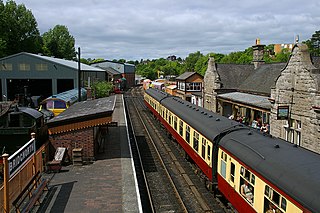
Bridgnorth railway station is a station on the Severn Valley Railway heritage line, serving the Shropshire town of Bridgnorth, England. It is currently the northern terminus of the SVR, home to the main engine shed and has a gift shop, station buffet and licensed refreshment room amongst other facilities.

Cound is a village and civil parish on the west bank of the River Severn in the English county of Shropshire, about 7 miles south east of the county town Shrewsbury. Once a busy and industrious river port Cound has now reverted to a quiet rural community and dormitory village, for commuters to the commercial centres of Shrewsbury and Telford.
The Severn Valley is a rural area of the West Midlands region of England, through which the River Severn runs and the Severn Valley Railway steam heritage line operates, starting at its northernmost point in Bridgnorth, Shropshire and running south for 16 miles (26 km) to Ribbesford, a few miles south of Bewdley, Worcestershire in the Wyre Forest.
Severn Valley Country Park is a country park in England, located near Alveley, Shropshire, 8 miles (13 km) from Bridgnorth, 7 miles from Kidderminster, roughly central in the Severn Valley. Originally the site of a huge coal mine, it is now a 126-acre (51 ha) park consisting of woodland, meadows and riverside banks with views over the River Severn and a Green Flag Award.
Stanmore Country Park is a 100-acre (40 ha) country park in Stanmore, Shropshire, 1.2 miles (2 km) east of Bridgnorth. Created in 1994 on the former site of RAF Bridgnorth, the park is run by the Shropshire County Council and contains an RAF memorial to those killed who were stationed at the military camp.

The River Worfe is a river in Shropshire, England. The name Worfe is said to derive from the Old English meaning to wander which the river is notable for in its middle section. Mapping indicates that the river begins at Cosford Bridge where the Cosford Brook and Albrighton Brook meet.
Rea Brook Valley is a country park, and Local Nature Reserve located in the town of Shrewsbury in Shropshire and is recognised nationwide as an important site for wildlife. This park is also known for its history in the Severn Valley Railway line. The Rea Brook is the watercourse that flows through the park.
References
- 1 2 3 4 5 6 Shropshire Council."Ropewalk Dingle countryside site ". Date retrieved: 19 July 2013
- ↑ Shropshire Star. "Name is decided for land". Date retrieved: 19 July 2013