
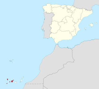
The Canary Islands, also known informally as the Canaries, are a Spanish archipelago and the southernmost autonomous community of Spain located in the Atlantic Ocean, in a region known as Macaronesia, 100 kilometres west of Morocco at the closest point.
Province of Santa Cruz de Tenerife, also Province of Santa Cruz, is a province of Spain, consisting of the western part of the autonomous community of the Canary Islands. It consists of about half of the Atlantic archipelago: the islands of Tenerife, La Gomera, El Hierro, and La Palma. It occupies an area of 3,381 km2 (1,305 sq mi). It also includes a series of adjacent roques.

La Gomera is one of Spain's Canary Islands, located in the Atlantic Ocean off the coast of Africa. With an area of 370.03 square kilometres (142.87 sq mi), it is the third smallest of the eight main islands of this archipelago. It belongs to the province of Santa Cruz de Tenerife. La Gomera is the third least populous of the eight main Canary Islands with 21,503 inhabitants. Its capital is San Sebastián de La Gomera, where the cabildo insular is located.

Gran Canaria, also Grand Canary Island, is the second most populous of the Canary Islands, an archipelago off the Atlantic coast of Northwest Africa which is part of Spain. As of 2019 the island had a population of 851,231 that constitutes approximately 40% of the population of the archipelago.

Tenerife is the largest and most-populated island of the eight Canary Islands. It is also the most-populated island of Spain, with a land area of 2,034.38 square kilometres (785.48 sq mi) and 917,841 inhabitants at the start of 2019, 43 percent of the total population of the Canary Islands. Tenerife is the largest and most-populous island of Macaronesia.

Mount Teide is a volcano on Tenerife in the Canary Islands, Spain. Its summit is the highest point in Spain and the highest point above sea level in the islands of the Atlantic.

Roque de los Muchachos is a rocky mound at the highest point on the island of La Palma in the Canary Islands, Spain. The rocks are found at an elevation of 2,423 m above sea level, not far from the Observatorio del Roque de los Muchachos, where some of the world's largest telescopes are situated; the altitude and the dryness of the climate here give rise to excellent observing conditions. The rocks are contained with the Parque Nacional de la Caldera de Taburiente.

Caldera de Taburiente National Park is a national park on the island of La Palma, Canary Islands, Spain. It contains the Caldera de Taburiente, which dominates the northern part of the island, and was designated as a national park in 1954. The telescopes of the Roque de los Muchachos Observatory are situated very close to the summit.

A volcanic plug, also called a volcanic neck or lava neck, is a volcanic object created when magma hardens within a vent on an active volcano. When present, a plug can cause an extreme build-up of pressure if rising volatile-charged magma is trapped beneath it, and this can sometimes lead to an explosive eruption. Glacial erosion can lead to exposure of the plug on one side, while a long slope of material remains on the opposite side. Such landforms are called crag and tail. If a plug is preserved, erosion may remove the surrounding rock while the erosion-resistant plug remains, producing a distinctive upstanding landform.

Tejeda is a village and a municipality in the mountainous central part of the island of Gran Canaria in the province of Las Palmas in the Canary Islands.

Hermigua is a town and a municipality in the northeastern part of La Gomera in the province of Santa Cruz de Tenerife of the Canary Islands, Spain. It is located 12 km northwest of the island's capital, San Sebastián de la Gomera. The Garajonay National Park covers the southern part of the municipality.

San Sebastián de La Gomera is the capital and a municipality of La Gomera in the Canary Islands, Spain. It also hosts the main harbour. The population was 8,699 in 2013, and the area is 113.59 square kilometres (43.86 sq mi).
Alajeró is a municipality on the island of La Gomera in the province of Santa Cruz de Tenerife in the Canary Islands. It is located on the south coast, SW of the capital San Sebastián de la Gomera. As well as being a municipality, Alajeró is also the name of the administrative town that governs that municipality.

Garajonay National Park is located in the center and north of the island of La Gomera, one of the Canary Islands (Spain). It was declared a national park in 1981 and a World Heritage Site by UNESCO in 1986. It occupies 40 km2 and it extends into each of the six municipalities on the island.

The Roman Catholic Diocese of San Cristóbal de La Laguna, also called Diocese of Tenerife or Diocese Nivariense, is a diocese located in the city of San Cristóbal de La Laguna in the Canary Islands in the Ecclesiastical province of Sevilla in Spain. The diocese includes the islands of Tenerife, La Palma, La Gomera and El Hierro, in the province of Santa Cruz de Tenerife. The bishop of this diocese is Bernardo Álvarez Afonso.

The conquest of the Canary Islands by the Crown of Castille took place between 1402 and 1496. It can be divided into two periods: the Conquista señorial, carried out by Castilian nobility in exchange for a covenant of allegiance to the crown, and the Conquista realenga, carried out by the Spanish crown itself, during the reign of the Catholic Monarchs.
Ignacio Lorenzo de Armas was a Spanish politician who served as mayor of San Antonio, Texas in 1738 and 1764. His family arrived in San Antonio from the Canary Islands in 1731 with other Canarian families in order to populate this region.

The 1983 Canarian regional election was held on Sunday, 8 May 1983, to elect the 1st Parliament of the Autonomous Community of the Canary Islands. All 60 seats in the Parliament were up for election. The election was held simultaneously with regional elections in twelve other autonomous communities and local elections all throughout Spain.
As in the rest of Spain, the majority religion in the Canary Islands is the Catholic Church. The Catholic religion has been the majority since the Conquest of the Canary Islands in the fifteenth century. This religion would largely replace the Canarian aboriginal religion through the prohibition of the latter and syncretism. According to a survey conducted in 2019, Canary Islands is the fifth autonomous community in Spain with the highest percentage of people who declare themselves to be Catholics after the Region of Murcia, Extremadura, Galicia, Aragon, and Castile and León. 76.7% of the population is Catholic.

The geology of the Canary Islands is dominated by volcanic rock. The Canary Islands and some seamounts to the north-east form the Canary Volcanic Province whose volcanic history started about 70 million years ago. The Canary Islands region is still volcanically active. The most recent volcanic eruption on land occurred in 1971 and the most recent underwater eruption was in 2011-12.

