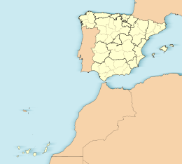
The Canary Islands, also known informally as the Canaries, are a Spanish region, autonomous community and archipelago in the Atlantic Ocean. At their closest point to the African mainland, they are 100 kilometres west of Morocco and the Western Sahara. They are the southernmost of the autonomous communities of Spain. The islands have a population of 2.2 million people and are the most populous special territory of the European Union.

The Province of Las Palmas is a province of Spain, consisting of the eastern part of the autonomous community of the Canary Islands. Las Palmas de Gran Canaria, capital city of this province and of the island of Gran Canaria, is the largest city in the Canary Islands.

Gran Canaria, also Grand Canary Island, is the third-largest and second-most-populous island of the Canary Islands, an archipelago off the Atlantic coast of Northwest Africa and is part of Spain. As of 2023 the island had a population of 862,893 that constitutes approximately 40% of the population of the archipelago. Las Palmas de Gran Canaria, the capital of the island, is the biggest city of the Canary Islands and the ninth of Spain.

Graciosa Island or commonly La Graciosa is a volcanic island in the Canary Islands of Spain, located two kilometres north of Lanzarote across the Strait of El Río. As the rest of the Canary Islands, it was formed by the Canary hotspot. The island is part of the Chinijo Archipelago and the Chinijo Archipelago Natural Park. It is administered by the municipality of Teguise in the neighboring island of Lanzarote. In 2018 La Graciosa was officially declared the eighth Canary Island by the Spanish Senate, with few real effects. Before then, the island had the status of an islet. It's administratively dependent on the island of Lanzarote.
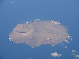
Alegranza is an uninhabited island in the Atlantic Ocean, located off the coast of Africa and is in the province of Las Palmas in the Canary Islands, Spain. It is the northernmost point in the Canary Islands, and part of the Chinijo Archipelago. The island is part of the municipality of Teguise on Lanzarote.

Montaña Clara is a small uninhabited islet belonging to the Chinijo Archipelago, in the northeastern part of the Canary Islands, only a short distance northwest of La Graciosa. The islet area is only 1.33 km2. The highest point of the island is 256 m (840 ft) above sea level.

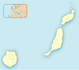
The Chinijo Archipelago is a small archipelago located in the northeastern part of the Canary Islands, north of the island of Lanzarote. The archipelago includes the islets of Montaña Clara, Alegranza, La Graciosa, Roque del Este and Roque del Oeste. The archipelago is administered by Lanzarote and belongs to the municipality of Teguise. La Graciosa is the only inhabited island, with a population of around 700.
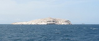
Roque del Oeste, also referred to as Roque del Infierno, is an uninhabited islet located 0.6 km northeast of the island of Montaña Clara, in the northeasternmost part of the Canary Islands, the Chinijo Archipelago. The highest point of the island is 41 m above sea level. The island is part of the nature reserve Los Islotes, which is part of the natural park Chinijo Archipelago.

The Federal Dependencies of Venezuela encompass most of Venezuela's offshore islands in the Caribbean Sea and the Gulf of Venezuela, excluding those islands that form the State of Nueva Esparta and some Caribbean coastal islands that are integrated with nearby states. These islands, with a total area of 342 square kilometres, are sparsely populated – according to the preliminary results of the 2011 Census only 2,155 people live there permanently, with another hundred from Margarita Island who live there seasonally to engage in fishing. Local government is officially under the authority of Central government in Caracas, although de facto power is often held by the heads of the sparse and somewhat isolated communities that decorate the territories.

Anaga massif is a mountain range in the northeastern part of the island of Tenerife in the Canary Islands. The highest point is 1,024 m. It stretches from the Punta de Anaga in the northeast to Cruz del Carmen in the southwest. Anaga features the mountain peaks of Bichuelo, Anambro, Chinobre, Pico Limante, Cruz de Taborno and Cruz del Carmen. The mountains were formed by a volcanic eruption about 7 to 9 million years ago making it the oldest part of the island. Since 1987 it has been protected as a "natural park", reclassified as "rural park" in 1994. Since 2015 it is also an UNESCO Biosphere Reserve and is the place that has the largest number of endemic species in Europe.

Mirador del Río is a viewpoint on an approximately 475-metre-high (1,560 ft) escarpment called Batería del Río in the north of the Canarian island of Lanzarote.

The Los Roques Archipelago is a federal dependency of Venezuela consisting of approximately 350 islands, cays, and islets in a total area of 40.61 km2 (15.68 sq mi). The archipelago is located 128 km (80 mi) directly north of the port of La Guaira, in the Caribbean Sea.
The Las Aves Archipelago is a pristine archipelago in the Caribbean Sea, and is part of the Federal Dependencies of Venezuela. It is located north of the Venezuelan states of Aragua and Carabobo, between the Dutch island Bonaire in the west, and the Los Roques Archipelago in the east, at 12°00′N67°40′W. The prime economic importance of the islands lies in fishing. "Las Aves" translates to "The Birds" in English.
The Los Monjes islands is a federal dependency of Venezuela are located to the northwest 80 kilometres of the Gulf of Venezuela, 34.8 kilometres off the coast of Guajira Peninsula at the border between Colombia and the Venezuelan state of Zulia.
The Mediterranean Acacia–Argania dry woodlands and succulent thickets is a Mediterranean forests, woodlands, and scrub ecoregion in North Africa centered mainly on Morocco but also including northwestern Western Sahara and the eastern Canary Islands.

The Roques de Anaga are two monolithic rocks forming some of the most emblematic natural monuments of Tenerife. Roque de Tierra stands 179 meters above sea level and is closer to the main island while Roque de Fuera, at 66 meters above sea level, is farther away. Both rocks are also included in the European Union's Natura 2000 ecological network of protected areas. They are located off the north-east coast of Tenerife.
Famara is the main mountainous massif in the north of the island of Lanzarote in the Canary Islands. It is the eastern slope of a volcano erupting in the Miocene. The cliffs of Famara are the remains of a caldera of about ten kilometres in diameter centred on the south of La Graciosa.

El Río is the name given to the sea strait that separates La Graciosa from Lanzarote in the Canary Islands. Río, in Spanish, means 'river'. At its narrowest point, the strait is just over 1.1 kilometres wide.
The Canary Islands dry woodlands and forests is a Mediterranean forests, woodlands, and scrub ecoregion in the Canary Islands. It encompasses the western group of the Canary Islands – La Palma, El Hierro, La Gomera, Tenerife, and Gran Canaria – in the Atlantic Ocean. These volcanic islands are an autonomous community of Spain, and lie southwest of the Spanish mainland and west of the North African coast.