Rosalie, Queensland

Last updated

Rosalie is a former suburb of Brisbane, Queensland, Australia. Since 1975, it has been a neighbourhood within the suburb of Paddington. [1]

Contents

History

The name Rosalie is probably derived from the Rosalie Plains pastoral station leased by John Frederick McDougall, who also owned land in the Milton and Rosalie areas of Brisbane. [1]

On Sunday 5 April 1884, a Baptist church opened in Rosalie, being described as a "neat little chapel" and was 20 by 20 feet (6.1 by 6.1 m). [2] [3] [4] On Saturday 7 November 1925, a new Baptist church was opened. [2] [5] [6]

Floods along Bayswater Road, Rosalie, 1890 StateLibQld 1 130791 Floods along Bayswater Road, Rosalie, Brisbane, 1890.jpg
Floods along Bayswater Road, Rosalie, 1890

Rosalie was subject to flooding in the 1890 Brisbane floods.

Evacuating from Rosalie, 2011 Evacuating from Rosalie in the Brisbane suburb of Paddington.jpg
Evacuating from Rosalie, 2011

The lower parts of Rosalie were inundated in the 2011 Brisbane Floods. [7]

Amenities

The centre of Rosalie contains many local shops and restaurants. They are all located closely to the intersection of Baroona Road and Nash Street. Nearby parks and playgrounds include Gregory Park and Frew Park.

Rosalie Baptist Church is at 97 Fernberg Road ( 27°27′46″S152°59′47″E / 27.4629°S 152.9965°E / -27.4629; 152.9965 (Rosalie Baptist Church) ). [8]

Heritage listings

Rosalie has a number of heritage-listed sites, including:

Related Research Articles

Gympie City in Queensland, Australia

Gympie is a city and a locality in the Gympie Region, Queensland, Australia. In the Wide Bay-Burnett District, Gympie is about 170.7 kilometres (110 mi) north of the state capital, Brisbane. The city lies on the Mary River, which floods Gympie occasionally. Gympie is the administrative centre for the Gympie Region area. As of June 2018 Gympie had a population of 51,578.

Beaudesert, Queensland Town in Queensland, Australia

Beaudesert is a rural town and locality in the Scenic Rim Region, Queensland, Australia. In the 2016 census, Beaudesert had a population of 6,395 people.

Coorparoo, Queensland Suburb of Brisbane, Queensland, Australia

Coorparoo is a suburb in the City of Brisbane, Queensland, Australia. In the 2016 census Coorparoo had a population of 16,282 people.

Toowong Suburb of Brisbane, Queensland, Australia

Toowong is a riverside inner suburb of Brisbane, Queensland, Australia. Toowong is 5 kilometres (3.1 mi) west of the Brisbane CBD, within the Paddington Ward of Brisbane City Council.

Yandina, Queensland Town in Queensland, Australia

Yandina is a rural town and locality in the Sunshine Coast Region, Queensland, Australia. In the 2016 census the locality of Yandina had a population of 2,371 people.

Cooroy, Queensland Town in Queensland, Australia

Cooroy is a rural town and locality in the Shire of Noosa, Queensland, Australia. In the 2016 census the locality of Cooroy had a population of 3,791 people.

Oxley, Queensland Suburb of Brisbane, Queensland, Australia

Oxley is a south-western suburb in the City of Brisbane, Queensland, Australia. It is located approximately 10.8 kilometres (6.7 mi) from the Brisbane CBD. It was named after the early Australian explorer John Oxley. The suburb supports a mix of residential, retail and industrial land.

Taringa, Queensland Suburb of Brisbane, Queensland, Australia

Taringa is a suburb in the City of Brisbane, Queensland, Australia. In the 2016 census, Taringa had a population of 8,376 people.

Ashgrove, Queensland Suburb of Brisbane, Queensland, Australia

Ashgrove is a suburb in the City of Brisbane, Queensland, Australia. In the 2016 census, Ashgrove had a population of 13,039 people.

Wynnum, Queensland Suburb of Brisbane, Queensland, Australia

Wynnum is a coastal suburb in the City of Brisbane, Queensland, Australia. In the 2016 census, Wynnum had a population of 12,915. The suburb is a popular destination in Brisbane due to its coastline, jetty and tidal wading pool.

Chelmer, Queensland Suburb of Brisbane, Queensland, Australia

Chelmer is a south-western suburb in the City of Brisbane, Queensland, Australia. In the 2016 census Chelmer had a population of 2,998 people.

Goodna, Queensland Suburb of Ipswich, Queensland, Australia

Goodna is a suburb on the eastern edge of the City of Ipswich in Queensland, Australia. In the 2016 census, Goodna had a population of 10,461 people.

Paddington, Queensland Suburb of Brisbane, Queensland, Australia

Paddington is an inner suburb in the City of Brisbane, Queensland, Australia. In the 2016 census, Paddington had a population of 8,562 people.

Red Hill, Queensland Suburb of Brisbane, Queensland, Australia

Red Hill is an inner northern suburb in the City of Brisbane, Queensland, Australia. In the 2016 census, Red Hill had a population of 5,560 people.

Graceville, Queensland Suburb of Brisbane, Queensland, Australia

Graceville is a suburb in the City of Brisbane, Queensland, Australia. In the 2016 census Graceville had a population of 4,634 people.

Enoggera, Queensland Suburb of Brisbane, Queensland, Australia

Enoggera is a suburb in the City of Brisbane, Queensland, Australia. In the 2016 census, Enoggera had a population of 5,157 people.

Marist Brothers College Rosalie School in Paddington, Brisbane, Queensland, Australia

Sacred Heart College, also known as Marist Brothers Rosalie, was a Catholic boys' college located in Paddington, an inner western suburb of Brisbane, Queensland, Australia. The college had been a high school for students in grades 8 to 12, but was closed at the end of 2008. Some of the school buildings were heritage-listed on the Queensland Heritage Register in 2008.

Ipswich (suburb), Queensland Suburb of Ipswich, Queensland, Australia

Ipswich is the central suburb and central business district in Ipswich in the City of Ipswich, Queensland, Australia. It is also known as Ipswich CBD. In the 2016 census, the suburb had a population of 2,459 people.

Rosalie RSL Hall

Rosalie RSL Hall is a heritage-listed school of arts at 50 Elizabeth Street, Paddington, City of Brisbane, Queensland, Australia. It was designed by Hall & Prentice and built from 1927 to 1928 by W Moody. It is also known as Rosalie School of Arts Commemoration Hall. It was added to the Queensland Heritage Register on 6 September 2005.

Marist Brothers College Rosalie Buildings

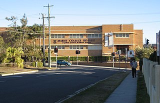
Marist Brothers College Rosalie Buildings are heritage-listed Roman Catholic monastery and school buildings at Fernberg Road, Rosalie, City of Brisbane, Queensland, Australia. They are also known as Marist Brothers' Monastery and Marist College. They were added to the Queensland Heritage Register on 18 September 2008.

References

  1. 1 2 "Rosalie (entry 29020)". Queensland Place Names. Queensland Government . Retrieved 11 January 2015.
  2. 1 2 "Queensland Baptist churches by date of erection/opening". Baptist Church Archives Queensland. Retrieved 29 November 2021.
  3. "1884 Rosalie". Baptist Church Archives Queensland. Retrieved 29 November 2021.
  4. "ROSALIE BAPTIST CHURCH". The Week . XVIII (460). Queensland, Australia. 18 October 1884. p. 6. Retrieved 2 December 2021 via National Library of Australia.
  5. "1925 Rosalie". Baptist Church Archives Queensland. Retrieved 29 November 2021.
  6. "ROSALIE BAPTISTS". The Daily Mail (7394). Queensland, Australia. 9 November 1925. p. 4. Retrieved 2 December 2021 via National Library of Australia.
  7. "Residents rush to leave sinking Rosalie". Sydney Morning Herald . 12 January 2011. Archived from the original on 24 September 2015. Retrieved 12 January 2015.
  8. "Rosalie Baptist Church". Churches Australia. Retrieved 2 December 2021.
  9. "RSL Hall Rosalie (entry 602517)". Queensland Heritage Register . Queensland Heritage Council. Retrieved 19 June 2013.
  10. "Rosalie Community Kindergarten and Preschool (entry 602380)". Queensland Heritage Register . Queensland Heritage Council. Retrieved 19 June 2013.
  11. "Marist Brothers' Monastery and Marist College (entry 602607)". Queensland Heritage Register . Queensland Heritage Council. Retrieved 6 July 2013.

Coordinates: 27°27′58″S152°59′49″E / 27.4661°S 152.9969°E / -27.4661; 152.9969