
Rosstrevor, New South Wales in Central Darling Shire is a remote rural locality and civil parish of Yungnulgra County in far North West New South Wales. [1] [2]
Rosstrevor, New South Wales in Central Darling Shire is a remote rural locality and civil parish of Yungnulgra County in far North West New South Wales. [1] [2]
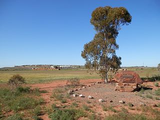
The Parish an arid landscape. The parish has a Köppen climate classification of BWh (Hot desert),. [3] is almost unpopulated, with less than two inhabitants per square kilometer. [4] The nearest town is Whitecliffs 2 km to the west.
The parish has extremely hot summers and mild winters. Summers would usually exceed 36 °C. Winters are usually around 17 °C. The annual average rainfall is 249.7 millimetres (9.8 in) which would make it a semi-arid climate except that its high evapotranspiration, or its aridity, makes it a desert climate.
| Climate data for White Cliffs Post Office (1901-2012) | |||||||||||||
|---|---|---|---|---|---|---|---|---|---|---|---|---|---|
| Month | Jan | Feb | Mar | Apr | May | Jun | Jul | Aug | Sep | Oct | Nov | Dec | Year |
| Record high °C (°F) | 48.6 (119.5) | 46.9 (116.4) | 44.1 (111.4) | 37.9 (100.2) | 31.9 (89.4) | 28.0 (82.4) | 28.8 (83.8) | 33.0 (91.4) | 39.5 (103.1) | 41.7 (107.1) | 45.0 (113.0) | 45.8 (114.4) | 48.6 (119.5) |
| Mean daily maximum °C (°F) | 35.8 (96.4) | 34.9 (94.8) | 31.6 (88.9) | 26.4 (79.5) | 21.4 (70.5) | 17.6 (63.7) | 17.2 (63.0) | 19.7 (67.5) | 23.9 (75.0) | 27.9 (82.2) | 31.5 (88.7) | 34.4 (93.9) | 26.9 (80.4) |
| Mean daily minimum °C (°F) | 20.9 (69.6) | 20.4 (68.7) | 17.2 (63.0) | 12.4 (54.3) | 8.2 (46.8) | 5.3 (41.5) | 4.1 (39.4) | 5.6 (42.1) | 9.0 (48.2) | 12.9 (55.2) | 16.4 (61.5) | 19.2 (66.6) | 12.6 (54.7) |
| Record low °C (°F) | 12.1 (53.8) | 8.8 (47.8) | 7.2 (45.0) | 2.6 (36.7) | −0.5 (31.1) | −2.3 (27.9) | −3.3 (26.1) | −1.7 (28.9) | 0.2 (32.4) | 2.0 (35.6) | 3.4 (38.1) | 6.8 (44.2) | −3.3 (26.1) |
| Average precipitation mm (inches) | 27.7 (1.09) | 27.1 (1.07) | 23.8 (0.94) | 15.4 (0.61) | 20.8 (0.82) | 19.0 (0.75) | 18.2 (0.72) | 15.4 (0.61) | 15.0 (0.59) | 23.2 (0.91) | 19.2 (0.76) | 25.1 (0.99) | 249.7 (9.83) |
| Average precipitation days | 3.0 | 2.8 | 2.5 | 2.2 | 3.4 | 3.7 | 3.8 | 3.4 | 3.0 | 3.6 | 3.1 | 3.0 | 37.5 |
| Source: [5] | |||||||||||||

The Parish is on the traditional lands of the Wandjiwalgu. [6] [7] Aboriginal peoples. [8]
In 1838 Thomas Mitchell (explorer) travelled down the nearby Darling River.
Charles Sturt passed through the Wandjiwalgu lands during 1845, [9] and in 1861 the Burke and Wills expedition passed nearby. [10]

Milring Parish is a remote rural locality and civil parish of Evelyn County in far northwest New South Wales. located at 29°54′29″S 141°40′53″E.

Haynes is a remote civil parish of Evelyn County in far northwest New South Wales, located at 30°24′24″S 141°04′48″E.

Booraboonara located at 31°25′02″S 141°44′53″E is a remote civil parish of Mootwingee County in far North West New South Wales.
Gooruba, New South Wales, located at 30°23′56″S 142°11′53″E, is a remote civil parish of Mootwingee County in far North West New South Wales.
Wirra Wirra located at 31°01′25″S 143°07′19″ in Central Darling Shire is a remote rural locality and civil parish of Yungnulgra County in far North West New South Wales..

Munro Parish, New South Wales located at 30°59′34″S 143°13′26″E in Central Darling Shire is a remote rural locality and civil parish of Yungnulgra County in far North West New South Wales.
Kerno at 31°02′27″S 142°59′34″E in Central Darling Shire is a remote rural locality and civil parish of Yungnulgra County in far North West New South Wales..
Parkungi located at 30.5653°S 143.2202°E in Central Darling Shire, New South Wales is a remote rural locality and civil parish of Yungnulgra County in far North West New South Wales.
Mallambray (Parish), in Central Darling Shire is a remote rural locality and civil parish of Yungnulgra County in far North West New South Wales.
Gambool located at 31°05′15″S 143°13′25″E in Central Darling Shire is a remote rural locality and civil parish of Yungnulgra County in far North West New South Wales.
Menamurtee located at 31°04′22″S 143°10′00″E, south of White Cliffs, New South Wales in Central Darling Shire is a remote rural locality and civil parish of Yungnulgra County in far North West New South Wales.
Moonamurtie, New South Wales south of White Cliffs, New South Wales in Central Darling Shire is a remote rural locality and civil parish of Yungnulgra County in far North West New South Wales.
Ullollie, New South Wales is a remote rural locality and civil parish of Yungnulgra County in far North West New South Wales.
Beefwood Parish, New South Wales is a remote rural locality and civil parish of Yungnulgra County in far North West New South Wales.
Woraro Parish, New South Wales is a remote rural locality and civil parish of Yungnulgra County in far North West New South Wales.

Gnalta is a remote rural locality and civil parish of Yungnulgra County in far North West New South Wales.
Scott Parish, New South Wales is a remote rural locality and civil parish of Evelyn County, New South Wales in far northwest New South Wales. located at 29°38′31″S 142°01′00″E.
Wonominta, New South Wales is a remote rural locality and civil parish of Evelyn County in far northwest New South Wales. located at 30°18′40″S 141°05′05″E.
Parish of Kooltoo, New South Wales is a remote civil parish of Yantara County in far North West New South Wales. The geography of the parish is mostly the flat, arid landscape of the Channel Country. The parish has a Köppen climate classification of BWh.

Bonny Parish, New South Wales is a civil parish of Killara County, in Central Darling Shire.
| | This New South Wales geography article is a stub. You can help Wikipedia by expanding it. |