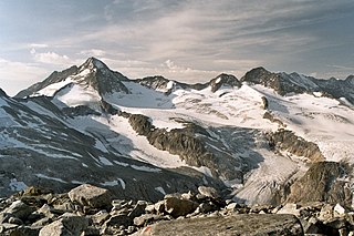
The Großes Wiesbachhorn is a mountain in the federal state of Salzburg, Austria and, at 3,564 m above sea level (AA), is the third-highest peak of the Hohe Tauern range.

The Dreiherrnspitze, at 3,499 m (11,480 ft) above mean sea level, is a mountain on the tripoint between the Austrian states of Salzburg and Tyrol, and South Tyrol in Italy. It is part of the Venediger Group in the Hohe Tauern range of the Central Eastern Alps and the Alpine divide.

The Glockner Group is a sub-group of the Austrian Central Alps in the Eastern Alps, and is located in the centre section of the High Tauern on the main chain of the Alps.

The Leogang Mountains are a mountain range in Austria in the state of Salzburg and form part of the Northern Limestone Alps within the Eastern Alps. They are located between the Lofer valley, Saalfelden and Leogang and, together with the Lofer Mountains to the northwest form two mountain massifs that are separated by the saddle of the Römersattel, but which the Alpine categorisation of the Eastern Alps defines as a single sub-group. The Leogang Mountains are separated from the Kitzbühel Alps to the south and the Steinernes Meer to the east by deeply incised valleys. Typical of the Steinberge are high plateaux with steep sides and sharply undulating high cirques.

The Großer Krottenkopf is the highest mountain in the Allgäu Alps of Austria. It is 2,656 m (AA) and is part of a side branch of the Hornbach chain, which branches off the main chain of the Allgäu Alps and runs for about 15 km eastwards.

The Goldberg Group is a sub-group of the Hohe Tauern mountain range within the Central Eastern Alps. It is located in Austria, in the states of Salzburg and Carinthia. Its highest peak is the Hocharn, 3,254 m (AA). Other well known summits are the Hoher Sonnblick, with its observatory at 3,106 m above sea level (AA), and the Schareck at 3,123 m above sea level (AA)

The Villgraten Mountains or Deferegg Alps, also called the Defreggen Mountains are a subgroup of the Austrian Central Alps within the Eastern Alps of Europe. Together with the Ankogel Group, the Goldberg Group, the Glockner Group, the Schober Group, the Kreuzeck Group, the Granatspitze Group, the Venediger Group and the Rieserferner Group, the Villgraten Mountains are part of the major mountain range, the High Tauern. Their highest summit is the Weiße Spitze with a height of 2,962 m above sea level (AA).

The Lechquellen Mountains or Lechquellen range is a small mountain group within the Northern Limestone Alps of the Eastern Alps. It lies entirely within the Austrian state of Vorarlberg and includes the upper reaches of the river Lech with its headstreams in a horseshoe shape as well as the Upper Großwalsertal valley.

The Hoher Eichham, at 3,371 m (AA), is the most dominant mountain in the southeastern part of the Venediger Group in the High Tauern in Austria. Four arêtes radiate from its summit towards the north, east, south and southwest. To the southeast is the glacier of Nilkees and, to the northeast, is the Hexenkees. The Großer Eichhamkees to the northwest and the Kleiner Eichhamkees to the southwest have shrunk to insignificant slabs of ice. On the North Arête is a rock tower, the Eichhamturm. Along the continuation of the arête lies the Großer Hexenkopf, which is roughly 600 metres as the crow flies from the Hoher Eichham. On the East Arête is the Niederer Eichham. From this subpeak a ridge branches southeast linking it with the Sailkopf; the lowest notch on this arête being the Sailscharte. The Hoher Eichham may have first been climbed during a military survey using triangulation in the 1850s. The first visit to the summit by tourists was on 16 July 1887 by Berlin alpinists, Carl Benzien and Hermann Meynow using the South Arête. They were led by the Zillertal mountain guide, Hans Hörhager, from Dornauberg.

The Hoher Sonnblick is a glaciated mountain, 3,106 m (AA) high, on the main Alpine chain in the Goldberg Group on the border between the Austrian states of Carinthia and Salzburg. At its summit is the Sonnblick Observatory and the Alpine refuge hut of Zittelhaus.

The Malhamspitzen are the four peaks of a mighty massif on the Maurerkamm, an Alpine mountain chain in the Venediger Group in Austria's High Tauern National Park. They rise south of the Reggentörl and are only separated from one another by small cols. The literature distinguishes them as follows:

The Großer Geiger, formerly also called the Obersulzbacher Venediger and Heiliggeistkogel, is a mountain, 3,360 m (AA), in the Venediger Group in the main chain of the Central Tauern. This chain lies in the High Tauern, part of the Austrian Central Alps on the border between the Austrian states of Tyrol in the south and Salzburg in the north.

The Keeskogel, a mountain with a height of 3,291 m (AA), lies in the Venediger Group of the High Tauern in Austria. The summit is located about 4 km as the crow flies northwest of the Großvenediger. The waymarked, glacier-free normal route from the Kürsinger Hut, is a relatively straightforward climb in dry and snow-free condition and takes about 1½ to 2 hours to reach the summit. Especially impressive in good weather is the view from the summit of the north side of the Großvenediger and the main chain of the Tauern and the glaciated landscape of the Obersulzbachkees and Untersulzbachkees.

The Schlieferspitze is a mountain, 3,290 m (AA), on the ridge known as the Krimmler Kamm in the Venediger Group of the Alps. The ridge lies in the northwest of the High Tauern, part of the Austrian Central Alps in the Austrian federal state of Salzburg. The summit is the highest on the Krimmler Kamm and is described in the sources as one of the most attractive peaks in the Venediger Group. From the valleys of the Krimmler Achental to the southwest and the Obersulzbachtal to the northeast it appears as an extremely dominant mountain. Long and evenly formed arêtes, about two kilometres long, run from the summit to the northwest, northeast, southeast and southwest. The mountain was first ascended on 22 August 1871 by Eduard Richter, professor of geography at the University of Graz, and Johann Stüdl, a merchant from Prague and co-founder of the German Alpine Club.

The Schareck, a mountain with a height of 3,123 m (AA), lies in the Goldberg Group of the High Tauern in Austria.

The Racherin, a mountain with a height of 3,092 m (AA), lies in the Glockner Group in the High Tauern range in Austria. The summit is located ca. 6 km, as the crow flies, northwest of Heiligenblut in the state of Carinthia. The unmarked and mostly trackless normal route is not difficult in snow-free and dry conditions, but is rather laborious. An ascent therefore requires a good sense of direction. In suitable weather there are good views from the top, including an impressive view of the Großglockner and the surrounding mountain world.

The Innere Wetterspitze is a mountain, 3,053 metres high, in the Stubai Alps in the Austrian state of Tyrol. It lies between the Stubai and Gschnitztal valleys, rising to the north of and above the col of Simmingjöchl and is separated by the Lautererseejoch from the rather higher Äußere Wetterspitze. The two Wetterspitzen sit on the Habichtkamm, a mountain ridge that branches off the main chain of the Alps near the Feuerstein and heads northeastwards to the Elferspitze.

The heavily glaciated Weißkamm is an Alpine chain that includes the Weißkugel and Wildspitze, the two highest peaks in the Ötztal Alps. Starting from the Weißkugel the Weißkamm runs for about 20 kilometres to the northwest towards Sölden. Other ridges branch off the Weißkamm striking northwards. From west to east these are the Glockturmkamm, the Kaunergrat and the Geigenkamm. The Weißkugel is where the Weißkamm joins the Schnalskamm, which runs in an easterly direction.

The Simonyspitzen are two mountain summits in the Venediger Group of the Austrian Central Alps. They lie within the High Tauern National Park on the border between the Austrian states of East Tyrol and Salzburg.

The Wertatscha is a mountain, 2,180 m above sea level (AA), in the Karavanks on the border between Austria and Slovenia. In the old German Alpine dialect it was also called the Deutscher Berg or Zinnenwand. Other names are the Meniška gora (Mönchsberg) and Rtača.


