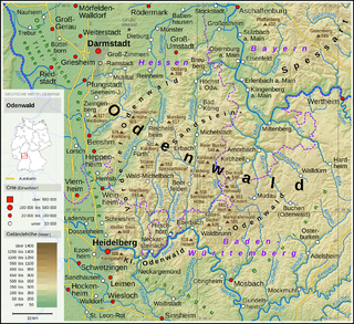
The Odenwald is a low mountain range in the German states of Hesse, Bavaria and Baden-Württemberg.

Heppenheim (Bergstraße) is the seat of Bergstraße district in Hesse, Germany, lying on the Bergstraße on the edge of the Odenwald. It is best known for being the birthplace of Sebastian Vettel, a four-time Formula One World Champion and the place of founding of the Free Democratic Party (Germany).

Schönbrunn is a municipality in the Rhein-Neckar district, Baden-Württemberg, Germany. It consists of the villages Allemühl, Haag, Moosbrunn, Schönbrunn and Schwanheim. It is situated in the southern part of the Odenwald hills, south of the river Neckar. Schönbrunn lies about 7 km southwest of Eberbach and 18 km east of Heidelberg.

Michelstadt in the Odenwald is a town in the Odenwaldkreis (district) in southern Hesse, Germany between Darmstadt and Heidelberg. It has a population of 28,629 people.

Erbach is a town and the district seat of the Odenwaldkreis (district) in Hesse, Germany. It has a population of around 14,000.
Birkenau in the Odenwald is a municipality in the Bergstraße district in southern Hesse, Germany. Its nickname is Das Dorf der Sonnenuhren – “The Sundial Village”.

Hirschhorn (Neckar) is a small town in the Bergstraße district of Hesse, Germany, and is known as "The Pearl of the Neckar valley”. Hirschhorn is a climatic health resort situated in the Geo-Naturpark Bergstraße-Odenwald.

Wald-Michelbach is a municipality in the Bergstraße district in Hesse, Germany.

Mörlenbach is a municipality in the Bergstraße district in southern Hesse, Germany.
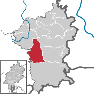
Höchst im Odenwald is a municipality in the Odenwaldkreis (district) in Hesse, Germany.
Bad König is a town and resort (Kurort) in the central Odenwald in the Odenwaldkreis (district) in Hesse, Germany, 29 km southeast of Darmstadt.
Beerfelden was a town in the Odenwald in the Odenwaldkreis (district) in Hesse, Germany, 28 km northeast of Heidelberg. On 1 January 2018 Beerfelden, Hesseneck, Rothenberg and Sensbachtal merged to create the town Oberzent.

The four-castle town of Neckarsteinach lies on the Neckar in the Bergstraße district in the southernmost part of Hesse, Germany, 15 km east of Heidelberg.

Fränkisch-Crumbach is a municipality in the Odenwaldkreis (district) in Hesse, Germany.
Hesseneck is a village and a former municipality in the Odenwaldkreis (district) in Hesse, Germany. With only just over 600 inhabitants, Hesseneck was Hesse’s smallest self-governing community. Since January 2018, it is part of the new town Oberzent.
Mossautal in the Odenwald is a municipality and a state-recognized health resort in the Odenwaldkreis (district) in Hesse, Germany.
Sensbachtal is a village and a former municipality in the Odenwaldkreis (district) in Hesse, Germany. Since January 2018, it is part of the new town Oberzent.
The Überwald is a wooded area in the southeast of Bergstraße district in Hesse, Germany, between the "Anterior" and "Hinder" Odenwald, comprising the communities of Abtsteinach, Grasellenbach and Wald-Michelbach. Wald-Michelbach is the Überwald's central community. The name was likely first used by the inhabitants of the neighbouring Weschnitz valley. The direction of view from this valley goes over the higher elevation at the Tromm, "over the forest" towards the higher-lying places Wald-Michelbach, Abtsteinach and Grasellenbach.
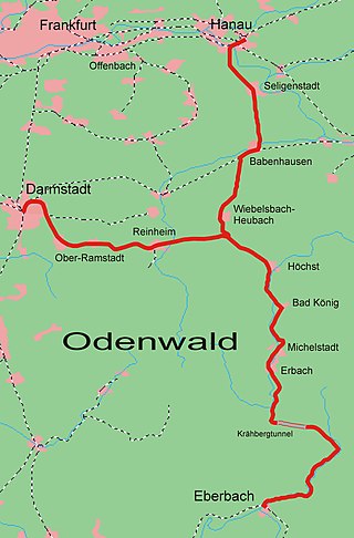
The Odenwald Railway is a mainly single-tracked main line from Darmstadt and Hanau to Eberbach on the River Neckar, which crosses the Odenwald mountains in the German states of Hesse and Baden-Württemberg. Since 1882 the route has been operated throughout as a standard gauge line and since 2005 has been worked by diesel multiples owned by the VIAS private railway company.
Oberzent is a town in the district of Odenwaldkreis, in Hesse, Germany. It was created with effect from 1 January 2018 by the merger of the former town Beerfelden and the former municipalities of Hesseneck, Rothenberg and Sensbachtal.


