Roto-o-Rangi

Last updated

Roto-o-Rangi
Village
Roto-o-Rangi
Coordinates: 37°58′44″S175°27′36″E / 37.979°S 175.460°E / -37.979; 175.460 Coordinates: 37°58′44″S175°27′36″E / 37.979°S 175.460°E / -37.979; 175.460
Country New Zealand
Region Waikato Region
District Waipa District
Population
 (2018 census)
  Territorial336
Time zone UTC+12 (NZST)
  Summer (DST) UTC+13 (NZDT)

Roto-o-Rangi or Rotoorangi is a rural community in the Waipa District and Waikato region of New Zealand's North Island, located south of Cambridge and north-east of Te Awamutu.

Contents

Parts of northern Roto-o-Rangi have been undergoing urban development since the construction of the State Highway 1 Cambridge Expressway, as part of the expansion of Cambridge. [1] The rest of Roto-o-Rangi is sparely populated with a small number of homes and businesses, including a furniture shop run out of a converted dairy farm barnhouse. [2]

Roto-o-rangi translates to Lake of Heaven, referring to a lake that once covered the area. [3]

History

European settlement

A European farmer and three of his workers arrived in 1864 and drained the lake to create rolling farm, under a lease agreement with local Māori that some Māori did not agree to. [3]

The area became the site of conflict during the Waikato War. A fortification was built to accommodate 60 men on the main road between Cambridge and Te Awamutu. [3] The last recorded European death from the war was farm worker Tim Sullivan on 24 April 1873; the pocket knife he had been carrying shortly before his death is on display at Cambridge Museum. [4]

Modern history

The Gricelands cream skimming factory was built at Roto-o-rangi in 1903. Settlers had to built their own roads to the factory. A Cambridge-based teacher and post-master opened a school in the settlement two years later, in February 1905, sending children home once a week with letters from their parents. [3]

The Roto-o-Rangi Memorial Hall was opened on 8 September 1938, following a fundraising campaign by the local community. A supper room was added in 1949, and the hall was expanded with a new roof in 1958.

The hall has been a venue for many community events. Dances were held at the hall through the decades, with women usually outnumbering men. The local school, Country Women's Institute, Federated Farmers, Young Farmers Club, Playcentre, The Ping Pong Club, Indoor Bowls,Tennis Club, church groups, jazz musicians, ballet classes and politicians have also used the hall for events. [5]

Roto O Rangi Road has recently been the site of fatal crashes. [6]

Demographics

Historical population
YearPop.±% p.a.
20061,401    
20131,548+1.44%
20181,686+1.72%
Source: [7]

The statistical area of Rotoorangi, which at 182 square kilometres is much larger than this locality, also includes Rangiaowhia. It had a population of 1,686 at the 2018 New Zealand census, an increase of 138 people (8.9%) since the 2013 census, and an increase of 285 people (20.3%) since the 2006 census. There were 591 households. There were 864 males and 822 females, giving a sex ratio of 1.05 males per female. The median age was 37.9 years (compared with 37.4 years nationally), with 390 people (23.1%) aged under 15 years, 279 (16.5%) aged 15 to 29, 813 (48.2%) aged 30 to 64, and 204 (12.1%) aged 65 or older.

Ethnicities were 91.8% European/Pākehā, 11.9% Māori, 0.9% Pacific peoples, 2.8% Asian, and 1.2% other ethnicities (totals add to more than 100% since people could identify with multiple ethnicities).

The proportion of people born overseas was 13.3%, compared with 27.1% nationally.

Although some people objected to giving their religion, 54.4% had no religion, 35.2% were Christian, 0.0% were Hindu, 0.0% were Muslim, 0.0% were Buddhist and 2.7% had other religions.

Of those at least 15 years old, 219 (16.9%) people had a bachelor or higher degree, and 240 (18.5%) people had no formal qualifications. The median income was $42,600, compared with $31,800 nationally. The employment status of those at least 15 was that 768 (59.3%) people were employed full-time, 219 (16.9%) were part-time, and 39 (3.0%) were unemployed. [7]

Roto-o-Rangi locality is in meshblocks 0988400, 0988800 and 0989000, which had a population of 336 people in the 2018 census. [8]

Education

Roto-o-Rangi School is a state primary school for Year 1 to 6 students, [9] with a roll of 99. [10]

Puahue School, another state primary school for Year 1 to 6 students, is located southeast of the township. [11] It has a roll of 146. [12] The school opened in 1912. [13]

Both schools are co-educational. Rolls are as of March 2020. [14]

Related Research Articles

Ngāruawāhia Town in Waikato, New Zealand

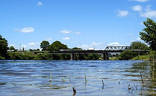
Ngāruawāhia is a town in the Waikato region of the North Island of New Zealand. It is located 20 kilometres (12 mi) north-west of Hamilton at the confluence of the Waikato and Waipa Rivers, adjacent to the Hakarimata Range. Ngāruawāhia is in the Hamilton Urban Area, the fourth largest urban area in New Zealand. The location was once considered as a potential capital of New Zealand.

Te Awamutu is a town in the Waikato region in the North Island of New Zealand. It is the council seat of the Waipa District and serves as a service town for the farming communities which surround it. Te Awamutu is located some 30 kilometres (19 mi) south of Hamilton on State Highway 3, one of the two main routes south from Auckland and Hamilton.

Otorohanga is a north King Country town in the Waikato region in the North Island of New Zealand. It is located 53 kilometres (33 mi) south of Hamilton and 18 kilometres (11 mi) north of Te Kuiti, on the Waipa River. It is a service town for the surrounding dairy-farming district. It is recognised as the "gateway" to the Waitomo Caves and as the "Kiwiana Town" of New Zealand. Until 2007, Otorohanga held a yearly 'Kiwiana Festival.'

Ruakura is a semi-rural suburb of Hamilton City, in the Waikato region of New Zealand. The University of Waikato is nearby.

Kawhia Harbour Place in Waikato region, New Zealand

Kawhia Harbour is one of three large natural inlets in the Tasman Sea coast of the Waikato region of New Zealand's North Island. It is located to the south of Raglan Harbour, Ruapuke and Aotea Harbour, 40 kilometres southwest of Hamilton. Kawhia is part of the Otorohanga District Council and is in the King Country. It has a high-tide area of 68 km2 (26 sq mi) and a low-tide area of 18 km2 (6.9 sq mi).

Kihikihi Place in Waikato, New Zealand

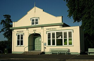
Kihikihi, a small town located in the Waikato region of the North Island of New Zealand, serves as a satellite community of Te Awamutu, five kilometres to the north, and lies 35 kilometres south of Hamilton. The 2018 New Zealand census recorded a population of 2,808 people The main reason for the large increase since 2013 is the construction of a large number of new dwellings.

Port Waikato Place in Waikato, New Zealand

Port Waikato is on the south bank of the Waikato River at its outflow into the Tasman Sea, in northern New Zealand. It is currently a village with a population of 516 in the 2018 New Zealand census.

Pirongia Village in Waikato Region, New Zealand

Pirongia is a small town in the Waipa District of the Waikato region of New Zealand's North Island. It is 12 kilometres to the west of Te Awamutu, on the banks of the Waipa River, close to the foot of the 962 metre Mount Pirongia, which lies in Pirongia Forest Park to the west of the town.

Te Kauwhata is a small town in the north of the Waikato region of New Zealand, situated close to the western shore of Lake Waikare, some 40 km north of Hamilton.

Taupiri Town

Taupiri is a small town of about 450 people on the eastern bank of the Waikato River in the Waikato District of New Zealand. It is overlooked by Taupiri mountain, the sacred burial ground for the Waikato tribes of the Māori people, located just to the north.

Paterangi is a settlement in the Waikato region of New Zealand's North Island. It is located 10 km northwest of Te Awamutu. It is close to the site of one of the most strongly fortified pa built during the New Zealand wars of the late 19th century.

Te Pahu Village in Waikato region, New Zealand

Te Pahu is a rural community in the Waipa District and Waikato region of New Zealand's North Island, located just north of Cambridge across State Highway 1.

Onewhero Place in Waikato, New Zealand

Onewhero is a village and rural community in the Waikato District and Waikato region of New Zealand's North Island. The village had a population of about 390 in the 2018 New Zealand census;

Ōhaupō Rural locality in Waikato, New Zealand

Ōhaupō is a rural community in the Waipa District and Waikato region of New Zealand's North Island. It is located on State Highway 3, about halfway between Hamilton and Te Awamutu.

Pokuru is a rural community in the Waipa District and Waikato region of New Zealand's North Island.

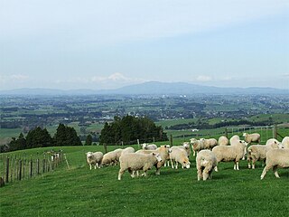
Pukeatua is a rural farming community in Waipa District and Waikato region of New Zealand's North Island. It is situated at the south-western foot of the Pukeatua hill, of the Maungatautari mountain range.

Ngāhinapōuri is a rural community in the Waipa District and Waikato region of New Zealand's North Island. It is located on State Highway 39, between Whatawhata and Pirongia.

Hautapu is a township in the Waipa District and Waikato region of New Zealand's North Island, located just north of Cambridge across State Highway 1.

Rukuhia is a rural community in the Waipa District and Waikato region of New Zealand's North Island.

Karapiro or Karāpiro is a settlement and rural area in the Waipa District and Waikato region of New Zealand's North Island. It includes both the artificially created Lake Karapiro and the accompanying Karapiro Power Station. Karapiro is located just off State Highway 1, south-west of Cambridge.

References

  1. Lewis, Geoff (18 April 2018). "Council offers land for more Cambridge development". Stuff. Waikato Times.
  2. James, Emma (4 August 2017). "Waikato barn turns into unique furniture shop". Stuff. Waikato Times.
  3. 1 2 3 4 Parker, Elis. "Roto-o-rangi". cambridgemuseum.org.nz. Cambridge Museum.
  4. "Pocket Knife Donated by Miss Annie Arnold". cambridgemuseum.org.nz. Cambridge Museum.
  5. Bain, Mike (24 March 2017). "War time period no barrier for Roto-o-Rangi to establish its community hall". Stuff. Waikato Times.
  6. "Motorcyclist killed in crash near Te Awamutu". New Zealand Media and Entertainment. The New Zealand Herald. 8 October 2016. "The human toll of the darkest week on our roads". New Zealand Media and Entertainment. The New Zealand Herald. 11 April 2019.
  7. 1 2 "Statistical area 1 dataset for 2018 Census". Statistics New Zealand. March 2020. Rotoorangi (184600). 2018 Census place summary: Rotoorangi
  8. "Meshblock Electoral Populations 2020 for proposed boundaries data". Statistics New Zealand. April 2020. Meshblocks 0988400, 0988800 and 0989000.
  9. Education Counts: Roto-o-Rangi School
  10. "Education Review Office Report". ero.govt.nz. Education Review Office.
  11. Education Counts: Puahue School
  12. "Education Review Office Report". ero.govt.nz. Education Review Office.
  13. "Puahue School 1912-2012, Ellicott's Block School 1936-1952 (archive record)". Te Awamutu Museum. Retrieved 7 November 2020.
  14. "New Zealand Schools Directory". New Zealand Ministry of Education. Retrieved 26 April 2020.