Roundstone, Kentucky

Last updated

Roundstone
USA Kentucky location map.svg
Red pog.svg
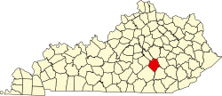
Roundstone
Location within the state of Kentucky
Usa edcp location map.svg
Red pog.svg
Roundstone
Roundstone (the United States)
Coordinates: 37°26′18″N84°18′53″W / 37.43833°N 84.31472°W / 37.43833; -84.31472
Country United States
State Kentucky
County Rockcastle
Elevation
[1]
942 ft (287 m)
Time zone UTC-5 (Eastern (EST))
  Summer (DST) UTC-4 (EDT)
GNIS feature ID515135 [1]

Roundstone is an unincorporated community in Rockcastle County, in the U.S. state of Kentucky. [1] It is located at the junction of U.S. Route 25, Kentucky Route 1786, and Kentucky Route 1617. The CC Subdivision runs through Roundstone.

History

A post office called Roundstone was established in 1856, and remained in operation until 1893. [2] The community took its name from nearby Roundstone Creek. [3]

Related Research Articles

<span class="mw-page-title-main">Jackson County, Kentucky</span> County in Kentucky, United States

Jackson County is located in the Commonwealth of Kentucky. As of the 2020 census, the population was 12,955. Its county seat is McKee. The county was formed in 1858 from land given by Madison, Estill, Owsley, Clay, Laurel, and Rockcastle counties. It was named for Andrew Jackson, seventh President of the United States. Jackson County became a moist county via a "local-option" referendum in the Fall of 2019 that legalized the sale of alcoholic beverages in the city of McKee.

Annville is an unincorporated community, a census-designated place (CDP), and the largest community in Jackson County, KY. As of the 2020 census, the population was 1,102. The community was established in 1878 and named for local resident Nancy Ann Johnson. The community offers a few services such as a post office, grocery store, gas station, medical clinic, nursing home, restaurants, and other locally owned businesses.

<span class="mw-page-title-main">McKee, Kentucky</span> City in Kentucky, United States

McKee is a home rule-class city located in the Commonwealth of Kentucky. It is the seat and second-largest community of Jackson County, KY. As of the 2020 census, the population of the city was 803. The city was founded on April 1, 1882, and was named for Judge George R. McKee. In 2019, the city held a vote regarding the sale of alcohol, which passed, making the city wet.

<span class="mw-page-title-main">Mount Vernon, Kentucky</span> City in Kentucky, United States

Mount Vernon is a home rule-class city and the seat of Rockcastle County in southeastern Kentucky. The intersection of U.S. Routes 25 and 150 is located here. The population was 2,477 at the time of the 2010 U.S. census. Mount Vernon is part of the Richmond-Berea micropolitan area.

Tomahawk is an unincorporated community that stretches along Kentucky Route 40 in Martin County, Kentucky, United States, in the eastern part of the state near the West Virginia border. It is located on Rockhouse Fork of Rockcastle Creek, approximately six miles (9.6 km) west of Inez, the county seat.

Orlando is an unincorporated community in Rockcastle County, Kentucky, United States. It is located at the junction of Kentucky Route 1004 and Kentucky Route 1912. The CC Subdivision runs through Orlando.

<span class="mw-page-title-main">Kentucky Route 595</span> State highway in Kentucky, United States

Kentucky Route 595 is a north- south route running through Madison County, Kentucky, United States. Its northern terminus is at the Kentucky River near Valley View and it southern terminus is at the intersection of Kentucky Route 1617 2 miles south of Berea. From the northern terminus to its intersection with Kentucky Route 876 it follows Silver Creek.

<span class="mw-page-title-main">Disputanta, Kentucky</span> Unincorporated community in Kentucky, United States

Disputanta is an unincorporated community located in Rockcastle County, Kentucky, United States. It is located on Kentucky Route 1787.

Wildie is an unincorporated community located in Rockcastle County, Kentucky, United States. It is located on Kentucky Route 1250 southeast of Roundstone.

Pongo, is an unincorporated community in Rockcastle County, Kentucky, United States. It is located on Kentucky Route 1249 south of Mount Vernon.

Climax, is an unincorporated community in Rockcastle County, Kentucky, United States. It is located on Kentucky Route 1912 north of Orlando. Climax has been noted for its unusual place name.

Wabd, is an unincorporated community in Rockcastle County, Kentucky, United States. It was also called Green Yard. The name refers to the post office founder William A. B. Davis.

Rockcastle, formerly Rock Castle, is an unincorporated community in Trigg County, Kentucky, United States.

Willailla is an unincorporated community in Rockcastle County, Kentucky, United States. It is located at the junction of Kentucky Route 70 and Kentucky Route 3273. It was named for the constant illness of a resident named Will Owens.

Roundstone Creek is a stream located entirely within Rockcastle County, Kentucky.

<span class="mw-page-title-main">Kentucky Route 461</span> State highway in Kentucky, United States

Kentucky Route 461 (KY 461) is a 18.015-mile-long (28.992 km) state highway in the U.S. state of Kentucky. The highway connects mostly rural areas of Pulaski and Rockcastle counties with Mount Vernon.

Hummel is an unincorporated community in Rockcastle County, Kentucky, United States. The community is accessed from Kentucky Route 1786 or U.S. Route 25 via Hummel Road.

The Rockcastle County School District is a public school district based in Mount Vernon, Kentucky in the United States. All of the schools in the Rockcastle County School District are based in Mount Vernon.

On the afternoon of November 22, 2023, at approximately 2:23 PM ET, a CSX mixed freight train derailed in Rockcastle County, Kentucky, causing a major spill of molten sulfur chemicals near Roundstone Creek, a creek located northwest of Livingston. Only one member of the CSX train's two-person crew was treated at the scene for minor injuries. The incident occurred six days after a similar CSX derailment that happened in Atlanta, Georgia.

References

  1. 1 2 3 U.S. Geological Survey Geographic Names Information System: Roundstone, Kentucky
  2. "Rockcastle County". Jim Forte Postal History. Retrieved December 24, 2015.
  3. Rennick, Robert M. Kentucky Place Names. University Press of Kentucky. p. 256. ISBN   0-8131-2631-2.