Hereford is a cathedral city, civil parish and the county town of Herefordshire, England. It lies on the River Wye, approximately 16 miles (26 km) east of the border with Wales, 24 miles (39 km) southwest of Worcester, and 23 miles (37 km) northwest of Gloucester. With a population of 60,800, it is by far the largest settlement in Herefordshire.
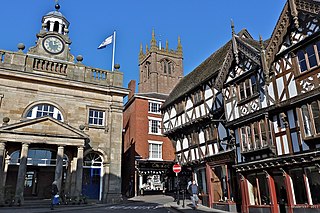
Ludlow is a market town in Shropshire, England. The town is significant in the history of the Welsh Marches and in relation to Wales. It is located 28 miles (45 km) south of Shrewsbury and 23 miles (37 km) north of Hereford, on the A49 road which bypasses the town. The town is near the confluence of the rivers Corve and Teme. The oldest part is the medieval walled town, founded in the late 11th century after the Norman conquest of England. It is centred on a small hill which lies on the eastern bank of a bend of the River Teme. Situated on this hill are Ludlow Castle and the parish church, St Laurence's, the largest in the county. From there the streets slope downward to the River Teme, and northward toward the River Corve. The town is in a sheltered spot beneath Mortimer Forest and the Clee Hills, which are clearly visible from the town.

Shrewsbury School is a public school in Shrewsbury.

Church Stretton is a market town in Shropshire, England, 13 miles (21 km) south of Shrewsbury and 15 miles (24 km) north of Ludlow. The population in 2011 was 4,671.

The West Midlands is one of nine official regions of England at the first level of International Territorial Level for statistical purposes. It covers the western half of the area traditionally known as the Midlands. The region consists of the counties of Herefordshire, Shropshire, Staffordshire, Warwickshire, West Midlands and Worcestershire. The region has seven cities Birmingham, Coventry, Hereford, Lichfield, Stoke-on-Trent, Wolverhampton and Worcester. The largest towns in the region with large population centres are Bromsgrove, Burton-upon-Trent, Cannock, Dudley, Great Malvern, Halesowen, Kidderminster, Leamington Spa, Nuneaton, Redditch, Rugby, Shrewsbury, Solihull, Stafford, Stourbridge, Sutton Coldfield, Tamworth, Telford, Walsall and West Bromwich.

Bishop's Castle is a market town in the south west of Shropshire, England. According to the 2011 Census it had a population of 1,893.

Ellesmere is a town in Shropshire, England, located near the Welsh border and the towns of Oswestry, Whitchurch and Wrexham. It is notable for its proximity to a number of prominent Meres.

Shrewsbury Castle is a red sandstone castle in Shrewsbury, Shropshire, England. It stands on a hill in the neck of the meander of the River Severn on which the town originally developed. The castle, directly above Shrewsbury railway station, is a Grade I listed building.

Pontesbury is a village and civil parish in Shropshire and is approximately eight miles southwest of Shrewsbury. In the 2011 census, the village had a population of 1,873 and the parish had a population of 3,227. The village of Minsterley is just over a mile further southwest. The A488 road runs through the village, on its way from Shrewsbury to Bishop's Castle. The Rea Brook flows close by to the north with the village itself nestling on the northern edge of the Shropshire Hills AONB. Shropshire County Council in their current Place Plan detail the development strategy and refer to Pontesbury and neighbouring Minsterley as towns.
Shropshire was established during the division of Saxon Mercia into shires in the 10th century. It is first mentioned in 1006. After the Norman Conquest it experienced significant development, following the granting of the principal estates of the county to eminent Normans, such as Roger De Montgomery and his son Robert de Bellême.

Montagu William Lowry-Corry, 1st Baron Rowton,, also known as "Monty", was a British philanthropist and public servant, best known for serving as Benjamin Disraeli's private secretary from 1866 until the latter's death in 1881.

Hawkstone Park is a historic landscape park with pleasure grounds and gardens formerly belonging to Hawkstone Hall, just north east of the small village of Weston-under-Redcastle, near to Market Drayton, in Shropshire, England. It is one mile (1.6 km) east of the A49 road. The park is known for its follies.

Condover Hall is an elegant Grade I listed three-storey Elizabethan sandstone building, described as the grandest manor house in Shropshire, standing in a conservation area on the outskirts of Condover village, Shropshire, England, four miles south of the county town of Shrewsbury.

Shrewsbury railway station is in Shrewsbury, Shropshire, England. Built in 1848, it was designated a grade II listed building in 1969.

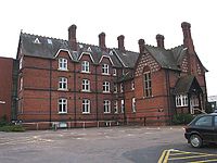
The Royal National College for the Blind (RNC) is a co-educational specialist residential college of further education based in the English city of Hereford. Students who attend the college are aged 16 to 25 and blind or partially sighted. They can study a wide range of qualifications at RNC, from academic subjects such as English and Mathematics to more vocational topics such as Massage and Complementary Therapies. Alongside regular further education subjects and vocational training, the college offers training in mobility, assistive technology, Braille, independent living skills and personal development.
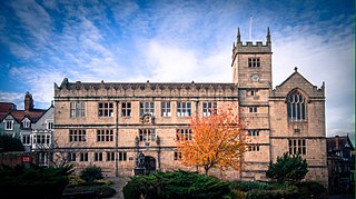
Shrewsbury Library is housed in a Grade I listed building situated on Castle Gates near Shrewsbury Castle. The site was the home of Shrewsbury School from 1550 until 1882. The buildings were handed over to the town in 1882 and a free library and museum were opened by the Corporation of Shrewsbury utilizing the building in 1885. The library was moved temporarily to Raven Meadows in 1976 while the site on Castle Gates underwent extensive restorations. The library was re-opened in 1983 by Princess Margaret.

Rowton is a small village in the Telford and Wrekin Borough, Shropshire, England. It is located seven miles north-west of Wellington. The area is a Chapelry Division of High Ercall Parish.

Shrewsbury is a market town and the county town of Shropshire, England, on the River Severn, 150 miles (240 km) north-west of London; at the 2011 census, it had a population of 71,715.
Sir Thomas Lyster of Rowton Castle (1612–1655), supported King Charles I during the English Civil War.

Richard Lyster of Rowton Castle, Shropshire, was a British landowner and Tory politician who sat in the House of Commons for 34 years between 1722 and 1766