
Sheridan County is a county in the U.S. state of Wyoming. As of the 2020 United States Census, the population was 30,921. The county seat is Sheridan. Its northern boundary abuts the Montana state border.

Crook County is a county in the northeastern corner of the U.S. state of Wyoming. As of the 2020 United States Census, the population was 7,181, making it the third-least populous county in Wyoming. Its county seat and largest city is Sundance. The county is located at the northwestern extreme of the Black Hills, which are its defining geographical feature.

Campbell County is a county in the U.S. state of Wyoming. As of the 2020 United States Census, the population was 47,026, making it the third-most populous county in Wyoming. Its county seat is Gillette.

Wheatland is a town in and the county seat of Platte County in southeastern Wyoming, United States. The population was 3,588 at the 2020 census.

BNSF Railway is the largest freight railroad in the United States. One of six North American Class I railroads, BNSF has 36,000 employees, 33,400 miles (53,800 km) of track in 28 states, and over 8,000 locomotives. It has three transcontinental routes that provide rail connections between the western and eastern United States. BNSF trains traveled over 169 million miles in 2010, more than any other North American railroad.
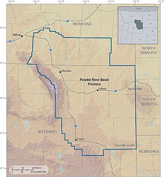
The Powder River Basin is a geologic structural basin in southeast Montana and northeast Wyoming, about 120 miles (190 km) east to west and 200 miles (320 km) north to south, known for its extensive coal reserves. The former hunting grounds of the Oglala Lakota, the area is very sparsely populated and is known for its rolling grasslands and semiarid climate.

Interstate 80 (I-80) is a part of the Interstate Highway System that runs from San Francisco, California, to Teaneck, New Jersey. In Wyoming, the Interstate Highway runs 402.76 miles (648.18 km) from the Utah state line near Evanston east to the Nebraska state line in Pine Bluffs. I-80 connects Cheyenne, Wyoming's capital and largest city, with several smaller cities along the southern tier of Wyoming, including Evanston, Green River, Rock Springs, Rawlins, and Laramie. The highway also connects those cities with Salt Lake City to the west and Omaha to the east. In Cheyenne, I-80 intersects I-25 and has Wyoming's only auxiliary Interstate, I-180. The Interstate runs concurrently with US Highway 30 (US 30) for most of their courses in Wyoming. I-80 also has shorter concurrencies with US 189 near Evanston, US 191 near Rock Springs, and US 287 and Wyoming Highway 789 (WYO 789) near Rawlins. The Interstate has business loops through all six cities along its course as well as a loop serving Fort Bridger and Lyman east of Evanston.

Interstate 25 (I-25) is a part of the Interstate Highway System that runs from Las Cruces, New Mexico, to Buffalo, Wyoming. In Wyoming, the Interstate Highway runs 300.530 miles (483.656 km) from the Colorado state line near Cheyenne north to its national terminus at I-90 near Buffalo. I-25 connects Wyoming's largest city and capital, Cheyenne, with its second largest city, Casper, and the smaller communities of Wheatland, Douglas, and Buffalo. The highway also connects those cities with Denver and Billings via I-90. I-25 runs concurrently with U.S. Route 87 (US 87) for almost its entire course in Wyoming. The highway also has extensive concurrencies with US 20 and US 26 along its east–west segment through the North Platte River valley. The Interstate has business loops through Cheyenne, Chugwater, Wheatland, Douglas, Glenrock, Casper, and Buffalo.
Interstate 90 (I-90) in the US state of Wyoming traverses the northeastern corner of the state, passing through the cities and communities of Sheridan, Buffalo, and Gillette.

Cheyenne is the capital and most populous city of the U.S. state of Wyoming, as well as the county seat of Laramie County, with 65,132 residents, per the 2020 census. It is the principal city of the Cheyenne metropolitan statistical area which encompasses all of Laramie County and had 100,512 residents as of the 2020 census. Local residents named the town for the Cheyenne Native American people in 1867 when it was founded in the Dakota Territory. Along with Oklahoma City, Oklahoma and Topeka, Kansas, Cheyenne is one of three state capitals with an indigenous name in a state with an indigenous name.
Dahinda is an unincorporated community in Knox County, Illinois, United States. It is part of the Galesburg Micropolitan Statistical Area. Dahinda is in Persifer Township and lies approximately one mile north of U.S. Highway 150 and Interstate 74. Knox County Highway 15 runs from north to south through Dahinda. Once a bustling town, as time has gone on, the businesses in this community moved on, but the community still continues to exist.
Wyarno is an unincorporated community in central Sheridan County, Wyoming, United States. It lies along Wyoming Highway 336, approximately 10 miles (16 km) east of the city of Sheridan, the county seat of Sheridan County. Although Wyarno is unincorporated, it has a post office, with the ZIP code of 82845. Public education in the community of Wyarno is provided by Sheridan County School District #2.

Gillette is a city in and the county seat of Campbell County, Wyoming, United States. The town was founded in 1891 as a major railway town on the Chicago, Burlington and Quincy Railroad.

Campbell County School District #1 is a public school district based in Gillette, Wyoming, United States.
Wyoming Highway 51 is a 24.79-mile (39.90 km) long east–west Wyoming state highway located in Campbell and Crook Counties, between Gillette and Moorcroft.

Dewey is an unincorporated community near the southwest corner of Custer County, South Dakota, United States, less than one mile from the Wyoming border in a prairie region of the Black Hills. There are approximately five or six homes in town. Dewey has a volunteer fire department in the Edgemont city district.
Dudley is an unincorporated community and census-designated place (CDP) in Fall River County, South Dakota, United States. The population was 28 at the 2020 census. It was first listed as a CDP prior to the 2020 census.

The Bighorn Divide and Wyoming Railroad, founded in 1985, is a shortline railroad in Wyoming, United States. The company originally operated under the name Bad Water Line before its current operator purchased it in 2002. It operates 41.2 miles (66.3 km) of track within the state, including a line it owns between Shoshoni and Bonneville, Wyoming, along with trackage rights over BNSF Railway to Lysite that allow it to access a branch line to an oil facility. The company also performs switching at a rail yard near Casper, Wyoming, that is unconnected to its other operations.


