Antelope Valley-Crestview, Wyoming

Last updated
Antelope Valley-Crestview, Wyoming
Antelope Valley in Campbell County, Wyoming.jpg
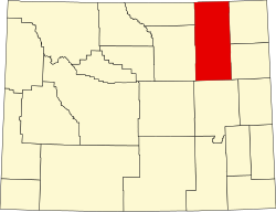
Campbell County Wyoming incorporated and unincorporated areas Antelope Valley-Crestview highlighted.svg
Location in Campbell County, Wyoming and the state of Wyoming.
Coordinates: 44°13′39″N105°28′24″W / 44.22750°N 105.47333°W / 44.22750; -105.47333 Coordinates: 44°13′39″N105°28′24″W / 44.22750°N 105.47333°W / 44.22750; -105.47333 [1]
Country United States
State Wyoming
County Campbell
Area
  Total4.9 sq mi (12.7 km2)
  Land4.9 sq mi (12.7 km2)
  Water0.0 sq mi (0.0 km2)
Elevation
[1]
4,715 ft (1,437 m)
Population
 (2010) [2]
  Total1,658
  Density340/sq mi (130/km2)
Time zone UTC-7 (Mountain (MST))
  Summer (DST) UTC-6 (MDT)
Area code 307
FIPS code 56-02900 [3]
GNIS feature ID2407747 [1]

Antelope Valley-Crestview was a census-designated place (CDP) in Campbell County, Wyoming, United States. The population was 1,658 at the 2010 census. Antelope Valley-Crestview was annexed by the nearby city of Gillette at the beginning of 2018.

Contents

History

Crestview Estates Park in the Crestview Estates part of Antelope Valley-Crestview Crestview Estates Park in Gillette, Wyoming.jpg
Crestview Estates Park in the Crestview Estates part of Antelope Valley-Crestview

Antelope Valley-Crestview was annexed by the city of Gillette on January 1, 2018. [4]

Geography

According to the United States Census Bureau, the CDP had a total area of 4.9 square miles (12.7 km2), all land.

Demographics

As of the census [3] of 2000, there were 1,642 people, 545 households, and 459 families residing in the CDP. The population density was 333.8 people per square mile (128.9/km2). There were 567 housing units at an average density of 115.2/sq mi (44.5/km2). The racial makeup of the CDP was 96.65% White, 0.06% African American, 1.10% Native American, 0.18% Asian, 0.24% from other races, and 1.77% from two or more races. Hispanic or Latino of any race were 2.98% of the population.

There were 545 households, out of which 50.8% had children under the age of 18 living with them, 75.0% were married couples living together, 5.7% had a female householder with no husband present, and 15.6% were non-families. 11.2% of all households were made up of individuals, and 0.9% had someone living alone who was 65 years of age or older. The average household size was 3.01 and the average family size was 3.27.

In the CDP, the population was spread out, with 33.4% under the age of 18, 8.0% from 18 to 24, 34.2% from 25 to 44, 22.9% from 45 to 64, and 1.5% who were 65 years of age or older. The median age was 32 years. For every 100 females, there were 112.1 males. For every 100 females age 18 and over, there were 109.2 males.

The median income for a household in the CDP was $70,833, and the median income for a family was $72,031. Males had a median income of $49,063 versus $26,905 for females. The per capita income for the CDP was $24,628. About 1.5% of families and 1.6% of the population were below the poverty line, including 1.9% of those under age 18 and none of those age 65 or over.

Education

Public education in the community of Antelope Valley-Crestview was provided by Campbell County School District #1.

Related Research Articles

<span class="mw-page-title-main">Campbell County, Wyoming</span> County in Wyoming, United States

Campbell County is a county in the U.S. state of Wyoming. As of the 2020 United States Census, the population was 47,026, making it the third-most populous county in Wyoming. Its county seat is Gillette.

<span class="mw-page-title-main">Littlerock, California</span> Census-designated place in California, United States

Littlerock is a census-designated place in California United States. The population was 1,377 at the 2010 census, down from 1,402 at the 2000 census. The Littlerock, and Sun Village community, which is typically referred to as Littlerock, has a population around 15,000. According to the Greater Antelope Valley Economic Alliance report of 2009, the Palmdale / Lancaster urban area has a population of 483,998, which Littlerock is a part of.

<span class="mw-page-title-main">Quartz Hill, California</span> Census-designated place in California, United States

Quartz Hill is a census-designated place (CDP) in Los Angeles County, California, United States. The population was 10,912 at the 2010 census, up from 9,890 at the 2000 census. The name is also shared with the neighboring district areas of its border cities, Palmdale, and Lancaster. Quartz Hill was once home to the Quartz Hill Airport. According to the Greater Antelope Valley Economic Alliance report of 2009, the Palmdale / Lancaster urban area of which Quartz Hill is a part, has a population of 483,998.

<span class="mw-page-title-main">Scott Lake, Florida</span> Neighborhood of Miami Gardens in Miami-Dade, Florida, United States

Scott Lake is a neighborhood in Miami Gardens, Florida. It was formerly its own census-designated place. The population was 14,401 at the 2000 census.

<span class="mw-page-title-main">Wright, Florida</span> Census-designated place in Florida

Wright is a census-designated place (CDP) in Okaloosa County, Florida, United States. The population was 23,127 at the 2010 United States Census. It is part of the Fort Walton Beach–Crestview–Destin Metropolitan Statistical Area.

<span class="mw-page-title-main">Lake Los Angeles, California</span> Census-designated place in California, United States

Lake Los Angeles is a census-designated place (CDP) in Los Angeles County, California, United States. The population was 12,328 at the 2010 census, up from 11,523 at the 2000 census. It is located 17 miles (27 km) east of Palmdale's Civic Center. According to the Greater Antelope Valley Economic Alliance report of 2009, the Palmdale / Lancaster urban area has a population of 483,998, which Lake Los Angeles is a part of.

<span class="mw-page-title-main">Vernon Valley, New Jersey</span> Census-designated place in New Jersey, United States

Vernon Valley is an unincorporated community and census-designated place (CDP) located in Vernon Township, in Sussex County, New Jersey, United States. As of the 2010 United States Census, the CDP's population was 1,626.

<span class="mw-page-title-main">Lincoln Park, New York</span> CDP in New York, United States

Lincoln Park is a hamlet in Ulster County, New York, United States. The population was 2,545 at the 2020 census.

<span class="mw-page-title-main">North Spearfish, South Dakota</span> Census-designated place in South Dakota, United States

North Spearfish is a census-designated place (CDP) in Lawrence County, South Dakota, United States. The population was 2,366 at the 2020 census.

<span class="mw-page-title-main">Rapid Valley, South Dakota</span> CDP in South Dakota, United States

Rapid Valley is a census-designated place (CDP) and unincorporated community in Pennington County, South Dakota, United States, and a suburb of Rapid City. The population was 8,098 at the 2020 census. Rapid Valley has been a retreat for people living in Rapid City due to its low crime, cheap land, and views of the Black Hills. Rapid Valley is home to many industrial and financial businesses, and is the headquarters for many corporations specializing in transport and engineering.

<span class="mw-page-title-main">Antelope, South Dakota</span> CDP in South Dakota, United States

Antelope is a census-designated place (CDP) in Todd County, South Dakota, United States. The population was 830 at the 2020 census.

<span class="mw-page-title-main">Auburn, Wyoming</span> Census-designated place in Wyoming, United States

Auburn is a census-designated place (CDP) in Lincoln County, Wyoming, United States. As of the 2010 census, the CDP population was 328.

<span class="mw-page-title-main">Etna, Wyoming</span> Census-designated place in Wyoming, United States

Etna is a census-designated place (CDP) in Lincoln County, Wyoming, United States. The population was 164 at the 2010 census.

<span class="mw-page-title-main">Smoot, Wyoming</span> Census-designated place in Wyoming, United States

Smoot is a census-designated place (CDP) in Lincoln County, Wyoming, United States. The population was 195 at the 2010 census.

Antelope Hills is a census-designated place in Natrona County, Wyoming, United States. It is part of the Casper, Wyoming Metropolitan Statistical Area. The population was 97 at the 2010 census.

Vista West is a census-designated place (CDP) in Natrona County, Wyoming, United States. It is part of the Casper, Wyoming Metropolitan Statistical Area. The population was 951 at the 2010 census.

<span class="mw-page-title-main">Arvada, Wyoming</span> Census-designated place in Wyoming, United States

Arvada is a census-designated place in Sheridan County, Wyoming, United States. The population was 33 at the 2020 census.

<span class="mw-page-title-main">Farson, Wyoming</span> CDP in Wyoming, United States

Farson is a census-designated place (CDP) in Sweetwater County, Wyoming, United States. The population was 313 at the 2010 census.

<span class="mw-page-title-main">Orange (CDP), Massachusetts</span> Census-designated place in Massachusetts, United States

Orange is a census-designated place (CDP) in the town of Orange in Franklin County, Massachusetts, United States. The population was 4,018 at the 2010 census. It is part of the Springfield, Massachusetts Metropolitan Statistical Area.

Lisbon is a census-designated place (CDP) and the main village in the town of Lisbon in Grafton County, New Hampshire, United States. The population of the CDP was 965 at the 2020 census, out of 1,621 in the entire town.

References

  1. 1 2 3 U.S. Geological Survey Geographic Names Information System: Antelope Valley-Crestview, Wyoming
  2. "2010 City Population and Housing Occupancy Status". U.S. Census Bureau. Retrieved July 13, 2012.[ dead link ]
  3. 1 2 "U.S. Census website". United States Census Bureau . Retrieved 2008-01-31.
  4. Filbin, Patrick (2018-03-08). "City Accepts Deeds to Annexed Parks". Gillette News Record . Gillette, Wyoming. Retrieved 2018-08-16.