Weston, Wyoming

Last updated
Weston, Wyoming
USA Wyoming location map.svg
Red pog.svg
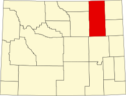
Weston
Location within the state of Wyoming
Usa edcp location map.svg
Red pog.svg
Weston
Weston (the United States)
Coordinates: 44°38′13″N105°20′10″W / 44.63694°N 105.33611°W / 44.63694; -105.33611 Coordinates: 44°38′13″N105°20′10″W / 44.63694°N 105.33611°W / 44.63694; -105.33611
Country United States
State Wyoming
County Campbell
Elevation
[1]
3,803 ft (1,159 m)
Time zone UTC-7 (Mountain (MST))
  Summer (DST) UTC-6 (MDT)
ZIP codes
82731
GNIS feature ID1604109 [1]

Weston is an unincorporated community in northern Campbell County, Wyoming, United States, along the upper Little Powder River on the southeastern edge of the Thunder Basin National Grassland. It lies along WYO 59 north of the city of Gillette, the county seat of Campbell County. [2] Its elevation is 3,802 feet (1,159 m). [1] Its post office has ZIP code of 82731. [3]

Education

Public education in the community of Weston is provided by Campbell County School District #1.

Related Research Articles

Kinnear is an unincorporated community in central Fremont County, Wyoming, United States. It lies along the concurrent U.S. Highways 26 and 287 at their intersection with Wyoming Highway 133, northwest of the city of Riverton and north of the city of Lander, the county seat of Fremont County. Its elevation is 5,400 feet (1,646 m). Kinnear has a post office, with the ZIP code of 82516.

Emblem is an unincorporated community in western Big Horn County, Wyoming, United States. The community has an official population of 10, although the surrounding rural area increases the number to over 100. It lies along the concurrent U.S. Routes 14, 16 and 20, west-northwest of the town of Basin, the county seat of Big Horn County. Its elevation is 4,449 ft (1,356 m). Although Emblem is unincorporated, it has a post office, with the ZIP code of 82422.

Frontier is an unincorporated community in southern Lincoln County, Wyoming, United States. It lies just north of the city of Kemmerer, the county seat of Lincoln County. Its elevation is 6,932 feet (2,113 m). Although Frontier is unincorporated, it had a post office, with the ZIP code of 83121 which closed in 2011.

Freedom is an unincorporated community in both northeastern Caribou County, Idaho, and northwestern Lincoln County, Wyoming, in the United States; the Wyoming portion of the community is also a census-designated place (CDP). The population was 214 at the 2010 census.

Alva is an unincorporated community in north central Crook County, Wyoming, United States. It lies along WYO 24, 34.9 miles north of the town of Sundance, the county seat of Crook County and 9.7 miles away from Hulett. Its elevation is 3,993 feet (1,217 m), and it is located at 44°41′41″N104°26′29″W. Although Alva is unincorporated, it has a post office, with the ZIP code of 82711. Population is 50.

<span class="mw-page-title-main">Arminto, Wyoming</span> Unincorporated community in Wyoming, United States

Arminto is an unincorporated community in northwestern Natrona County, Wyoming, United States. It lies along local roads west of the city of Casper, the county seat of Natrona County. Its elevation is 6,053 feet (1,845 m).

<span class="mw-page-title-main">Carpenter, Wyoming</span> Census-designated place in Wyoming, United States

Carpenter is an unincorporated community and census-designated place in southeastern Laramie County, Wyoming, United States. As of the 2010 census it had a population of 94. It lies along WYO 214 east of the city of Cheyenne, the county seat of Laramie County and capital of Wyoming. Its elevation is 5,440 feet (1,658 m). Although Carpenter is unincorporated, it has had a post office since 1907, with the ZIP code of 82054.

Garrett is an unincorporated community in northern Albany County, Wyoming, United States, along the North Laramie River. It lies along local roads north of the city of Laramie, the county seat of Albany County. Its elevation is 6,785 ft (2,068 m), and it is located at 42°6′48″N105°36′36″W. Although Garrett is unincorporated, it once had a post office, with the ZIP code of 82058. The building remains, though is no longer in use. Garrett is also home to River Bridge School, a one-room schoolhouse that is part of Albany County School District #1. Aside from the schoolhouse, the land is privately owned.

Hiland is an unincorporated community in western Natrona County, Wyoming, United States. It lies along the concurrent U.S. Routes 20 and 26, west of the city of Casper, the county seat of Natrona County. Its elevation is 6,004 feet (1,830 m). Although the Hiland post office closed in 2014, it retains a ZIP code of 82638. Hiland is so named because it formed the highest elevation point within the Wyoming portion of the Chicago and Northwestern Railroad: it was originally named Woolton at its founding, with the spelling later changed to Wolton until 1914, when most of Wolton's population moved to Arminto, the new, nearby railhead, and the remaining citizens renamed the town Hiland. As of 2014, the town consisted only of a bar catering to bikers, and an adjacent house.

<span class="mw-page-title-main">Hillsdale, Wyoming</span> Unincorporated community & census-designated place in Wyoming, United States

Hillsdale is an unincorporated community and census-designated place in southeastern Laramie County, Wyoming, United States. As of the 2010 census, it had a population of 47. It lies along local roads east of the city of Cheyenne, the county seat of Laramie County. Its elevation is 5,640 feet (1,720 m) above sea level. Although Hillsdale is unincorporated, it has a post office, with the ZIP code of 82060. Public education in the community of Hillsdale is provided by Laramie County School District #2.

Horse Creek is an unincorporated community in western Laramie County, Wyoming, United States. It lies between Horse Creek to the north, and the South Fork of Horse Creek to the south, along WYO 211 northwest of the city of Cheyenne, the county seat of Laramie County. Its elevation is 6,506 feet (1,983 m). Although Horse Creek is unincorporated, it does not have a post office, but it does have a ZIP code of 82061. As of the 2010 census, Horse Creek had an estimated population of 39.

Jay Em is an unincorporated community in northern Goshen County, Wyoming, United States, just below the headwaters of the Rawhide Creek, on the old Texas Trail. It lies along U.S. Route 85, 35 miles north of the city of Torrington, the county seat of Goshen County. Its elevation is 4,590 feet (1,399 m). Although unincorporated, Jay Em has a post office, with ZIP code 82219.

<span class="mw-page-title-main">Leiter, Wyoming</span> Unincorporated community in Wyoming, United States

Leiter is an unincorporated community in eastern Sheridan County, Wyoming, United States, along Clear Creek. It lies along the concurrent U.S. Routes 14 and 16, east of the city of Sheridan, the county seat of Sheridan County. Its elevation is 3,779 feet (1,152 m). Although Leiter is unincorporated, it has a post office, with the ZIP code of 82837. Public education in the community of Clearmont is provided by Sheridan County School District #3.

Linch is an unincorporated community in southeastern Johnson County, Wyoming, United States. It lies along WYO 192 southeast of the city of Buffalo, the county seat of Johnson County. Its elevation is 4,957 feet (1,511 m). Although Linch is unincorporated, it has a post office, with the ZIP code of 82640.

Lysite is an unincorporated community in northeastern Fremont County, Wyoming, United States. It lies along local roads northeast of the city of Lander, the county seat of Fremont County. Lysite has a post office. The Bridger Trail passed near Lysite on its way north to the gold fields of Montana in the 19th century.

Natrona is an unincorporated community in central Natrona County, Wyoming, United States. It lies along the concurrent U.S. Routes 20 and 26, west of the city of Casper, the county seat of Natrona County. Its elevation is 5,604 feet (1,708 m). Although Natrona is unincorporated, it has been assigned its own ZIP code of 82646.

Saddlestring is an unincorporated community in northwestern Johnson County, Wyoming, United States, on the eastern edge of the Bighorn National Forest. It lies along local roads northwest of the city of Buffalo, the county seat of Johnson County. Its elevation is 5,440 feet (1,658 m). Saddlestring possessed its own post office from 1946 to 1965, and from 1967 to 1999; although the post office is now closed, Saddlestring retains its old ZIP Code of 82840. The post office building still exists; located on the HF Bar Ranch, it is a contributing property to a historic district located on the ranch. The oldest building in Saddlestring is the log barn, which is attached to the Rock Creek Rod and Gun Club home to Rock Creek Anglers a guide service, fly shop and bar.

<span class="mw-page-title-main">Savery, Wyoming</span> Unincorporated community in Wyoming, United States

Savery is an unincorporated community in southeastern Carbon County, Wyoming, United States, on the upper Little Snake River. It lies along WYO 70 south of the city of Rawlins, the county seat of Carbon County. Its elevation is 6,473 feet (1,973 m). Although Savery is unincorporated, it has a post office with ZIP code 82332, and is home to the Little Snake River Museum.

Walcott is an unincorporated community in central Carbon County, Wyoming, United States. It lies along local roads near Interstate 80 and the concurrent U.S. Routes 30 and 287, east of the city of Rawlins, the county seat of Carbon County. Its elevation is 6,627 feet (2,020 m). It had a post office with the ZIP code of 82335, that closed in 2007.

Wyarno is an unincorporated community in central Sheridan County, Wyoming, United States. It lies along Wyoming Highway 336, approximately 10 miles (16 km) east of the city of Sheridan, the county seat of Sheridan County. Although Wyarno is unincorporated, it has a post office, with the ZIP code of 82845. Public education in the community of Wyarno is provided by Sheridan County School District #2.

References

  1. 1 2 3 "Weston, Wyoming". Geographic Names Information System . United States Geological Survey, United States Department of the Interior.
  2. Rand McNally. The Road Atlas '08. Chicago: Rand McNally, 2008, p. 116.
  3. Zip Code Lookup