Rubens, Iowa

Last updated

Rubens, Iowa
USA Iowa location map.svg
Red pog.svg
Rubens, Iowa
Usa edcp location map.svg
Red pog.svg
Rubens, Iowa
Coordinates: 42°49′21″N94°38′23″W / 42.822472°N 94.639701°W
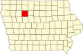
 / 42.822472; -94.639701
Country United States
State Iowa
County Pocahontas
Elevation
1,197 ft (365 m)
Time zone UTC-6 (Central (CST))
  Summer (DST) UTC-5 (CDT)
GNIS feature ID466288 [1]

Rubens is a ghost town in Pocahontas County, in the U.S. state of Iowa. [1]

History

The post office in the community was variously called Powhattan, Powhatan, and Reubens before it closed in 1884. [2] Rubens was named for Peter Paul Rubens, a Flemish painter. [3]

References

  1. 1 2 U.S. Geological Survey Geographic Names Information System: Rubens, Iowa
  2. U.S. Geological Survey Geographic Names Information System: Rubens Post Office (historical)
  3. Chicago and North Western Railway Company (1908). A History of the Origin of the Place Names Connected with the Chicago & North Western and Chicago, St. Paul, Minneapolis & Omaha Railways. p. 120.