Rubicon Estuary

Last updated

The estuary is an important site for pied oystercatchers Haematopus longirostris - Austins Ferry.jpg
The estuary is an important site for pied oystercatchers

The Rubicon Estuary is an estuary on the central coast of northern Tasmania, south-eastern Australia, lying next to the town of Port Sorell.

Estuary A partially enclosed coastal body of brackish water with one or more rivers or streams flowing into it, and with a free connection to the open sea

An estuary is a partially enclosed coastal body of brackish water with one or more rivers or streams flowing into it, and with a free connection to the open sea.

Tasmania island state of Australia

Tasmania is an island state of Australia. It is located 240 km (150 mi) to the south of the Australian mainland, separated by Bass Strait. The state encompasses the main island of Tasmania, the 26th-largest island in the world, and the surrounding 334 islands. The state has a population of around 526,700 as of March 2018. Just over forty percent of the population resides in the Greater Hobart precinct, which forms the metropolitan area of the state capital and largest city, Hobart.

Australia Country in Oceania

Australia, officially the Commonwealth of Australia, is a sovereign country comprising the mainland of the Australian continent, the island of Tasmania and numerous smaller islands. It is the largest country in Oceania and the world's sixth-largest country by total area. The neighbouring countries are Papua New Guinea, Indonesia and East Timor to the north; the Solomon Islands and Vanuatu to the north-east; and New Zealand to the south-east. The population of 25 million is highly urbanised and heavily concentrated on the eastern seaboard. Australia's capital is Canberra, and its largest city is Sydney. The country's other major metropolitan areas are Melbourne, Brisbane, Perth and Adelaide.

Contents

Description

The estuary has a shallow muddy substrate and is fed by several streams, including the Franklin Rivulet and Rubicon River. It is bounded by Port Sorell, Hawley Beach, Shearwater and Squeaking Point on the west, the Narawntapu National Park on the north-east, and pasture on the east and south. [1]

Shearwater, Tasmania Town in Tasmania, Australia

Shearwater is a town on the north coast of Tasmania, Australia. It lies on the Rubicon Rivulet, just off Bass Strait, 19.6 km east of Devonport. The town of Port Sorell and Hawley Beach neighbour Shearwater. At the 2016 census, Shearwater had a population of 1764. The town grows considerably during the holiday season. It is part of the Municipality of Latrobe.

Narawntapu National Park Protected area in Tasmania, Australia

Narawntapu is a national park in Tasmania, Australia. It lies on Tasmania's north coast, adjoining Bass Strait, between Port Sorell in the west and the mouth of the Tamar River in the east. It lies about 20 km east of Devonport, 60 km north-west of Launceston and 250 km north of Hobart.

Pasture land used for grazing

Pasture is land used for grazing. Pasture lands in the narrow sense are enclosed tracts of farmland, grazed by domesticated livestock, such as horses, cattle, sheep, or swine. The vegetation of tended pasture, forage, consists mainly of grasses, with an interspersion of legumes and other forbs. Pasture is typically grazed throughout the summer, in contrast to meadow which is ungrazed or used for grazing only after being mown to make hay for animal fodder. Pasture in a wider sense additionally includes rangelands, other unenclosed pastoral systems, and land types used by wild animals for grazing or browsing.

Birds

The site has been identified by BirdLife International as a 14 km2 Important Bird Area (IBA) because it supports over 1% of the world population of pied oystercatchers, as well as smaller numbers of other wader species. [2]

BirdLife International is a global partnership of conservation organisations that strives to conserve birds, their habitats, and global biodiversity, working with people towards sustainability in the use of natural resources. It is the world's largest partnership of conservation organisations, with over 120 partner organisations.

Important Bird Area area recognized as being globally important habitat for the conservation of birds populations

An Important Bird and Biodiversity Area (IBA) is an area identified using an internationally agreed set of criteria as being globally important for the conservation of bird populations.

Pied oystercatcher species of bird

The pied oystercatcher is a species of oystercatcher. It is a wading bird native to Australia and commonly found on its coastline. The similar South Island pied oystercatcher occurs in New Zealand.

Related Research Articles

Port Sorell, Tasmania Town in Tasmania, Australia

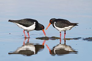
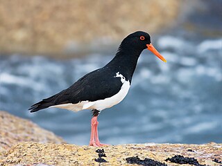
Port Sorell is a town on the north-west coast of Tasmania, Australia. It is on the waterway of the same name, just off Bass Strait, 20 km east of Devonport and close to Shearwater and Hawley Beach. It borders the Rubicon Estuary, which has been identified by BirdLife International as an Important Bird Area because of its importance for waders, especially pied oystercatchers.

Hawley Beach Town in Tasmania, Australia

Hawley Beach is a seaside resort town 22 kilometres (14 mi) from the nearest main town (Devonport). At the 2006 census, the town had a population of 483. Nearby is the small town of Port Sorell and locality of Shearwater.

Broad Sound (Queensland) sound in Australia

Broad Sound is a large bay on the east coast of Australia, in the state of Queensland 675 km northwest of the state capital, Brisbane. It is about 50 km long and 20 km across at its widest point. The Torilla Peninsula forms the eastern side of the bay; Shoalwater Bay is on the other side of the peninsula.

Duck Island (Victoria) island in Victoria, Australia

Duck Island, a small barrier island, lies 1.5 km north of Swan Island and south of Edwards Point in the main entrance to Swan Bay from Port Phillip in southern Victoria, Australia. It is part of the Port Phillip Heads Marine National Park and the plants and animals on and around the island are protected, including the critically endangered orange-bellied parrot. The island is part of the Swan Bay and Port Phillip Bay Islands Important Bird Area, identified as such by BirdLife International.

Orielton Lagoon

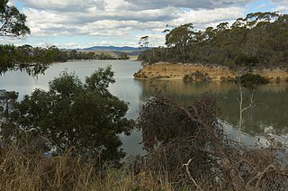
The Orielton Lagoon is a shallow dystrophic lagoon located west of Sorell in south east Tasmania, Australia.

Gulf Plains Important Bird Area Important Bird Area in Queensland, Australia

The Gulf Plains Important Bird Area comprises 8868 km2 of the low-lying coastal plains bordering the south-eastern corner of the Gulf of Carpentaria in north-west Queensland, Australia. It was identified by BirdLife International as an Important Bird Area (IBA) because of its importance to global populations of waders and other birds.

Gulf St Vincent Important Bird Area

The Gulf St Vincent Important Bird Area comprises land extending along the coast of Gulf St Vincent, north of Adelaide, South Australia.

Hunter Estuary Wetlands

The Hunter Estuary Wetlands comprise a group of associated wetlands at and near the mouth of the Hunter River in the city of Newcastle, New South Wales, Australia. Some 30 km2 of the wetlands has been recognised as being of international importance by designation under the Ramsar Convention. It was listed on 21 February 1984 as Ramsar site 287. A larger area of the wetlands has been identified by BirdLife International as an Important Bird Area (IBA). The wetlands are recognised as the most important area in New South Wales for waders, or shorebirds.

Murrumbidgee Red Gums Important Bird Area Important Bird Area in New South Wales, Australia

The Murrumbidgee Red Gums Important Bird Area comprises a 2451 km2 discontinuous linear tract of land stretching along the Murrumbidgee River west, and downstream, from Wagga Wagga in the Riverina region of New South Wales, Australia. It includes riverine red gum forest with adjacent woodland and farmland. It adjoins the Riverina Plains Important Bird Area.

South Arm Important Bird Area Important Bird Area in Tasmania, Australia

The South Arm Important Bird Area is a disjunct tract of mainly intertidal land on the eastern outskirts of Hobart, Tasmania, Australia.

St Helens Important Bird Area Important Bird Area in Tasmania, Australia

St Helens Important Bird Area comprises four separate sites, with a collective total area of 24 km2, in the vicinity of the town of St Helens on the northern part of the east coast of Tasmania, south-eastern Australia.

Sudbury Reef reef in Australia

Sudbury Reef is a small coral reef, with a few unnamed cays but no substantial islands, lying about 20 km off the east coast of Far North Queensland, Australia. It is part of the Great Barrier Reef Marine Park at about the same latitude as Cairns.

Swan Bay and Port Phillip Bay Islands Important Bird Area Important Bird Area in Victoria, Australia

The Swan Bay and Port Phillip Bay Islands Important Bird Area comprises a cluster of disparate sites centred at the eastern end of the Bellarine Peninsula, and the southern end of Port Phillip, in Victoria, south-eastern Australia. As well as providing core wintering habitat for orange-bellied parrots, it is important for waders, or shorebirds, and seabirds.

Tourville and Murat Bays Important Bird Area

Tourville and Murat Bays Important Bird Area is an important bird area in South Australia with a combined area of 117 square kilometres, located west to the town of Ceduna on the north-west corner of the Eyre Peninsula in the Great Australian Bight. It is considered to be an important area because of the resident populations of waders, or shorebirds.

Warby–Chiltern Box–Ironbark Region

The Warby–Chiltern Box–Ironbark Region comprises a cluster of separate blocks of remnant box-ironbark forest habitat, with a collective area of 253 km2, in north eastern Victoria, south-eastern Australia.

Werribee and Avalon Important Bird Area Important Bird Area in Victoria, Australia

The Werribee and Avalon Important Bird Area comprises some 37 km2 of coastal land along the north-western shore of Port Phillip in the state of Victoria, south-eastern Australia. The area is important for a wide variety of waterbirds.

Yambuk Important Bird Area Important Bird Area in Victoria, Australia

The Yambuk Important Bird Area comprises a 10 km2 tract of coastal land fronting Bass Strait in south-western Victoria, south-eastern Australia. It lies some 20 km west of the town of Port Fairy and encompasses the lower reaches of the Eumeralla River and Lake Yambuk.

Bellarine Wetlands Important Bird Area Important Bird Area in Victoria, Australia

The Bellarine Wetlands Important Bird Area comprises a group of wetland sites, with a collective area of 46 km2, at the western end of the Bellarine Peninsula in Victoria, south-eastern Australia. The site is important for waterbirds and orange-bellied parrots.

References

  1. BirdLife International. (2011). Important Bird Areas factsheet: Rubicon Estuary. Downloaded from http://www.birdlife.org on 2011-10-01.
  2. "IBA: Rubicon Estuary". Birdata. Birds Australia. Retrieved 2011-09-01.

Coordinates: 41°10′53″S146°34′33″E / 41.18139°S 146.57583°E / -41.18139; 146.57583

Geographic coordinate system Coordinate system

A geographic coordinate system is a coordinate system that enables every location on Earth to be specified by a set of numbers, letters or symbols. The coordinates are often chosen such that one of the numbers represents a vertical position and two or three of the numbers represent a horizontal position; alternatively, a geographic position may be expressed in a combined three-dimensional Cartesian vector. A common choice of coordinates is latitude, longitude and elevation. To specify a location on a plane requires a map projection.