Rudd Creek Pueblo

Last updated

The Rudd Creek Pueblo is an archaeological site in the Upper Little Colorado region in Springerville, Arizona just along the boundaries of the Mogollon and Anasazi culture areas. It is a late Tularosa phase site, dating from ca. 1225 to 1300, which is part of the Mogollan tradition, and located directly inside the Sipe White Mountain Wildlife Area. In 1996, the Rudd Creek Archaeological Project, a part of the Arizona State University Archaeological Field School, excavated the site to document the artifacts and architecture, and to observe and keep track the extent of pot hunting at the site, a problematic issue for not only this particular site but for archaeology as a whole. [1]

Contents

Site and environment

Rudd Creek Pueblo sits on a terrace that overlooks Rudd Creek (hence, the name) and is at an elevation of 2,335 meters (7,661 feet). The site is situated in a transitional area between the White Mountains and the Colorado Plateau and the Little Colorado River Valley. [2]

Rudd Creek Pueblo is located in an open valley, but has access to three different microenvironments: the juniper savanna, riparian areas, and the lower montane coniferous forest. [3] The inhabitants of Rudd Creek Pueblo, therefore, had access to a wide variety of flora and fauna and were able to exploit a broad spectrum of resources. [4]

Architecture

The architecture at Rudd Creek Pueblo is similar to other late Tularosa phase sites in the region, for example Coyote Creek Pueblo and Foote Canyon Pueblo. [5] The site consists of about forty rooms situated inside a sizeable, rectangular shaped masonry roomblock and two large depression areas that are interpreted as being possible locations of great kivas, or ceremonial and ritual centers. [6] The rectangular shaped pueblo is common and indicative of the Mogollon culture, and became common during the Tularosa phase. [7] Most of the rooms that make up Rudd Creek Pueblo have been disturbed by looting and pot hunting, but some still contain undisturbed or “in-situ” fill. [8] Many of the rooms have also been interpreted as probable habitation rooms, containing formal hearths, subfloor pits, and/or mealing bins or as storage rooms with very small floor areas and very few floor features. [9] In addition, a ceremonial room or possible separate structure has been identified (Unit 5) and houses a large raised platform and bench. A circular hearth and ventilator are also present in the center of this room, suggesting that inhabitants may have used this room for rituals or special gatherings. [10]

The construction of the walls in the main roomblock is mainly stone, and the walls are generally 20-40 centimeters wide. [11] Despite challenges presented from inadequate wall preservation and damages from pot-hunting, it is thought that brown plaster was initially covering the walls. [12] The interior and exterior surfaces of the walls, however, are not alike. [13] The interior walls consist of unformed limestone, sandstone, and cobbles that are laid in mortar or mud. The exterior walls are built of limestone, sandstone, and vesicular basalt as well as tabular chinking stones. In addition, the exterior walls were more uniform in their construction, while the interior walls appear to be more haphazardly or unsystematically built. [14] This difference is helpful in determining the building sequence of each room. The difference in wall construction indicates that the interior walls were built faster than the exterior walls. The masonry style of the walls at Rudd Creek Pueblo is, as expected, similar to other late Tularosa phase sites. [15]

Construction phases

There are four separate construction phases identified at Rudd Creek Pueblo. Based on analysis of the ceramic data at Rudd Creek Pueblo, site construction is thought to have begun between AD 1225-1250. [16] The initial construction phase resulted in a single, nuclear unit consisting of small, adjacent rooms. The subsequent middle phases of construction involved the building of new rooms and remodeling of old rooms, including filling doorways, niches, and ventilators. The interior masonry style of the subsequent building phases differs from the initial in that at least one of the interior walls of each room displayed the same planned and organized construction of the exterior surfaces. During the middle phases, rooms were built next to the eastern side of the pueblo. The last building phase took place in the northern area of the roomblock and is believed to have resulted in the construction of the rooms just south of one of the great kivas (Unit 15). [17] Due to excessive looting, determining when construction ended at Rudd Creek Pueblo is difficult, but probably occurred between AD 1250-1300. [18]

Great Kivas

Limited excavations were done in the two depressions just north and east of the main roomblock, but the areas each appear to be the location of a great kiva, where inhabitants of Rudd Creek Pueblo held ceremonies or ritual gatherings. The fill in the depression just north of the roomblock (Unit 15) yielded large amounts of ash and charred roof beam. Because of excessive looting in this unit, only a slab-lined cist was found in the base. A number of artifacts were found interred on the floor (three bone artifacts, a corrugated jar, two Tularosa Black-on-white jars, a Wingate Black-on-red bowl, an unidentifiable black and white ladle, a two-handed mano, and several mineral fragments) and appear to have been done so intentionally. The combination of these artifacts and the charred roof fragments in the fill lead to the possibility that this kiva was ritually decommissioned. [19]

The second depression located just east of the roomblock exposed a probable square and semi-subterranean kiva about thirteen meters long and considerably intact. Wall construction of this kiva is much like the wall construction of the roomblock. Similar to the previous kiva (Unit 15), the fill in this kiva is mostly ash and charred roof bits with only a small percentage of artifacts, leading to the idea that this kiva was burned or ritually decommissioned when abandoned. Similar square kivas have been identified at other late Tularosa sites, such as Coyote Creek and Foote Canyon. [20]

Assemblages found

Ceramic Assemblage

There were 11, 956 ceramic specimens recovered during the excavations at Rudd Creek Pueblo. Nineteen different types of slipped or painted pottery sherds made up one third of the assemblage and the remainder was mainly unpainted brown ware sherds; [21] brown ware pottery is very common in the Mogollon culture trend. [22] The most common types of ceramics represented in the Rudd Creek assemblage are Tularosa Black-on-white, St. John’s Black-on-red, and St. John’s polychrome, which places the assemblage in chronology with other sites from the late-Tularosa phase, although assemblages recovered from sites to the east of Rudd Creek Pueblo differ. [23] [24]

Lithic Assemblage

The majority of the lithics found at Rudd Creek Pueblo were flaked stone and unretouched, while formal tools that had been carefully produced into an intentional tool, were rare. There were 698 flaked stone artifacts recovered, of which more than 80% were made of high quality silicates (including chert, chalcedony, petrified wood, and quartzite). [25] The majority of these flakes have been identified as simple flakes and are thought to be the result of percussion reduction, or the product of producing flakes by direct impact. [26] As for formal tools, only a small number were recovered during excavation. Six unifaces, five bifaces, eleven saws/denticulates, and eleven projectile points were found and are similar to the tools documented at other Tularosa phase sites. [27] One room (Unit 6) yielded an unusual cache of stone tools in a closed floor pit. The cache consisted of a biface, three projectile points, and one red stone bead. The purpose of the cache is not known, but it has been interpreted that Rudd Creek Pueblo occupants might have gathered the tools from an adjacent area and kept them for ceremonial uses or out of curiosity. The large number of flaked stone in combination with few formal tools suggests that residents of the pueblo focused primarily on quick tool production and used stone flakes more often that formal tools. [28]

Flora and Faunal Assemblage

Because of the variety in environment that surrounds Rudd Creek Pueblo, a wide array of faunal remains were recovered, however, only the juniper savanna and montane forest were represented in the assemblage. In total, 906 specimens, representing 17 different taxa, were found including lagomorphs (rabbits and hares) and rodents. Only 14% of the faunal assemblage was made up of large-game specimens, the majority including deer and pronghorn antelope. [29] [30] It has been proposed that the area surrounding the pueblo was moderately vegetated due to the large number of specimens recovered that were herbivores. Carnivore specimens at Rudd Creek Pueblo are rare and it is suggested that what was recovered, remains of black bears and bobcats, are most likely indicative of animals that were utilized for their fur or for ritual use. [31] In addition, bird remains are present, including turkey and other birds such as golden eagles. Birds other than turkey that are represented in the assemblage are thought to be evidence of the inhabitants of Rudd Creek Pueblo acquiring feathers for special purposes or rituals rather than as a means of subsistence. [32]

Site occupation and dating

Dating Rudd Creek Pueblo was done through a combination of artifact/ceramic analysis and dendrochronology, because dendrochronology was unreliable on its own due to an inadequate number of datable samples. [33] Forty-three tree-ring samples were submitted, but only one could be dated. [34] The only viable sample, which came from one of the great kivas (Unit 7), yielded a non-cutting date of AD1275++vv, meaning that the correct date of the sample is earlier than reported because the tree was either damaged or not dead. The tree-ring sample in combination with temporal trends associated with the types of ceramics represented at Rudd Creek Pueblo place construction of the site during the mid-1200s AD, with an occupation lasting until around 1300 AD. [35]

It is believed that, through the evidence of structure burning and “in-situ” floor deposits, that Rudd Creek Pueblo was abandoned in a hurry. Two hypotheses have been proposed for why this was the case. The first is that the pueblo was burned due to widespread conflict, something seen commonly with other pueblos of the time period. [36] Another alternative has been proposed based on the evidence of interred artifacts and burning that suggests the inhabitants of Rudd Creek Pueblo ritually closed the structure, a trend that is seen in pueblos of following periods. [37]

Related Research Articles

Catron County, New Mexico U.S. county in New Mexico

Catron County is a county in the U.S. state of New Mexico. As of the 2010 census, the population was 3,725, making it New Mexico's third-least populous county. Its county seat is Reserve. Catron County is New Mexico's largest county by area.

Kiva Room used by Puebloans for religious rituals and political meetings

A kiva is a room used by Puebloans for rites and political meetings, many of them associated with the kachina belief system. Among the modern Hopi and most other Pueblo people, kivas are a large room that is circular and underground, and are used for spiritual ceremonies.

Mogollon culture

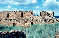
Mogollon culture is an archaeological culture of Native American peoples from Southern New Mexico and Arizona, Northern Sonora and Chihuahua, and Western Texas. The northern part of this region is Oasisamerica, while the southern span of the Mogollon culture is known as Aridoamerica.

Navajo National Monument

Navajo National Monument is a National Monument located within the northwest portion of the Navajo Nation territory in northern Arizona, which was established to preserve three well-preserved cliff dwellings of the Ancestral Puebloan people: Keet Seel, Betatakin, and Inscription House. The monument is high on the Shonto plateau, overlooking the Tsegi Canyon system, west of Kayenta, Arizona. It features a visitor center with a museum, three short self-guided trails, two small campgrounds, and a picnic area.

Pueblo Bonito Ancient Puebloan ruin in New Mexico

Pueblo Bonito is the largest and best-known great house in Chaco Culture National Historical Park, northern New Mexico. It was built by the Ancestral Puebloans who occupied the structure between AD 828 and 1126.

Oasisamerica Pre-Columbian cultural region of North America

Oasisamerica is a term that was coined by Paul Kirchhoff and published in a 1954 article, and is used by some scholars, primarily Mexican anthropologists, for the broad cultural area defining pre-Columbian southwestern North America. It extends from modern-day Utah down to southern Chihuahua, and from the coast on the Gulf of California eastward to the Río Bravo river valley. Its name comes from its position in relationship with the similar regions of Mesoamerica and mostly nomadic Aridoamerica. The term Greater Southwest is often used to describe this region by American anthropologists.

Casa Malpaís United States historic place

Casa Malpaís is an archaeological site of the Ancestral Puebloans located near the town of Springerville, Arizona. The site is a nationally recognized archaeological site and was declared a National Historic Landmark in 1964.

Salmon Ruins United States historic place

Salmon Ruins is an ancient Chacoan and Pueblo site located in the northwest corner of New Mexico, USA. Salmon was constructed by migrants from Chaco Canyon around 1090 CE, with 275 to 300 original rooms spread across three stories, an elevated tower kiva in its central portion, and a great kiva in its plaza. Subsequent use by local Middle San Juan people resulted in extensive modifications to the original building, with the reuse of hundreds of rooms, division of many of the original large, Chacoan rooms into smaller rooms, and emplacement of more than 20 small kivas into pueblo rooms and plaza areas. The site was occupied by ancient Ancestral Puebloans until the 1280s, when much of the site was destroyed by fire and abandoned. The pueblo is situated on the north bank of the San Juan River, just to the west of the modern town of Bloomfield, New Mexico, and about 45 miles (72 km) north of Pueblo Bonito in Chaco Canyon. The site was built on the first alluvial terrace above the San Juan River floodplain.

Chetro Ketl Ancestral Puebloan great house and archeological site in New Mexico, United States

Chetro Ketl is an Ancestral Puebloan great house and archeological site located in Chaco Culture National Historical Park, New Mexico, United States. Construction on Chetro Ketl began c. 990 and was largely complete by 1075, with significant remodeling occurring in the early and mid-1110s. Following the onset of a severe drought, most Chacoans emigrated from the canyon by 1140; by 1250 Chetro Ketl's last inhabitants had vacated the structure.

Kinishba Ruins United States historic place

Kinishba Ruins is a 600-room Mogollon great house archaeological site in eastern Arizona and is administered by the White Mountain Apache Tribe. It is located on the present-day Fort Apache Indian Reservation, in the Apache community of Canyon Day. As it demonstrates a combination of both Mogollon and Ancestral Puebloan cultural traits, archaeologists consider it part of the historical lineage of both the Hopi and Zuni cultures. It is designated as a National Historic Landmark.

Paul Sidney Martin was an American anthropologist and archaeologist. A lifelong associate of the Field Museum of Natural History in Chicago, Martin studied pre-Columbian cultures of the Southwestern United States. He excavated more than a hundred archaeological sites, starting with the groundbreaking seven-season expedition to the Montezuma County, Colorado in 1930–1938. His research passed through three distinct stages: field archaeology of the Anasazi Pueblo cultures of Colorado in the 1930s, studies of the Mogollon culture in 1939–1955 and the New Archaeology studies in 1956–1972. Martin collected more than 585 thousand archaeological artifacts although his own methods of handling these relics were at times destructive and unacceptable even by the standards of his time.

Cueva de la Ranchería is an archaeological site located south of Ciudad Madera, in the Sirupa Canyon region, northwest of the Mexican state of Chihuahua.

Pueblo I Period

The Pueblo I Period was the first period in which Ancestral Puebloans began living in pueblo structures and realized an evolution in architecture, artistic expression, and water conservation.

Pueblo II Period

The Pueblo II Period was the second pueblo period of the Ancestral Puebloans of the Four Corners region of the American southwest. During this period people lived in dwellings made of stone and mortar, enjoyed communal activities in kivas, built towers and water conversing dams, and implemented milling bins for processing maize. Communities with low-yield farms traded pottery with other settlements for maize.

Ancestral Puebloans Ancient Native American culture in Four Corners region of the United States

The Ancestral Puebloans were an ancient Native American culture that spanned the present-day Four Corners region of the United States, comprising southeastern Utah, northeastern Arizona, northwestern New Mexico, and southwestern Colorado. The Ancestral Puebloans are believed to have developed, at least in part, from the Oshara Tradition, who developed from the Picosa culture.

The Lower Zuni River Archeological District is an area of approximately 29,500 acres, comprising 89 distinct archeological sites. It is located approximately 24 miles northeast of St. Johns, Arizona, at the Arizona - New Mexico border, along the Zuni River.

Puerco Ruin and Petroglyphs USA NRHP Anasazi ruins

Puerco Ruin and Petroglyphs are the ruins of a large Indian pueblo, which reached its peak around 1300 A.D., containing over 100 rooms. It is the largest known archeological site within the Petrified Forest National Park.

Sherwood Ranch Pueblo United States historic place

Sherwood Ranch Pueblo is an historic pueblo located overlooking the Little Colorado River, near Springerville, Arizona. It has two areas of habitation, consisting of over 800 rooms and was inhabited from approximately 1000-1450 A.D.

Indigenous peoples of the North American Southwest

The indigenous peoples of the North American Southwest are those in the current states of Colorado, Arizona, New Mexico, Utah, and Nevada in the western United States, and the states of Sonora and Chihuahua in northern Mexico. An often quoted statement from Erik Reed (1964) defined the Greater Southwest culture area as extending north to south from Durango, Mexico to Durango, Colorado and east to west from Las Vegas, Nevada to Las Vegas, New Mexico. Other names sometimes used to define the region include "American Southwest", "North Mexico", "Chichimeca", and "Oasisamerica/Aridoamerica". This region has long been occupied by hunter-gatherers and agricultural people.

Samuel Watson Smith was an American archaeologist and researcher on the indigenous cultures and artifacts of the western Anasazi area.

References

  1. Clark, Tiffany C. 2006 Rudd Creek Pueblo: A Late Tularosa Phase Village in East Central Arizona. Kiva 71(4):401
  2. Clark, Tiffany C. 2006 Rudd Creek Pueblo: A Late Tularosa Phase Village in East Central Arizona. Kiva 71(4):398
  3. Clark, Tiffany C. 2006 Rudd Creek Pueblo: A Late Tularosa Phase Village in East Central Arizona. Kiva 71(4):399
  4. Clark, Tiffany C. 2006 Rudd Creek Pueblo: A Late Tularosa Phase Village in East Central Arizona. Kiva 71(4):399
  5. Clark, Tiffany C. 2006 Rudd Creek Pueblo: A Late Tularosa Phase Village in East Central Arizona. Kiva 71(4):401-402
  6. Clark, Tiffany C. 2006 Rudd Creek Pueblo: A Late Tularosa Phase Village in East Central Arizona. Kiva 71(4):401-402
  7. Clark, Tiffany C. 2006 Rudd Creek Pueblo: A Late Tularosa Phase Village in East Central Arizona. Kiva 71(4):400
  8. Clark, Tiffany C. 2006 Rudd Creek Pueblo: A Late Tularosa Phase Village in East Central Arizona. Kiva 71(4):401-402
  9. Clark, Tiffany C. 2006 Rudd Creek Pueblo: A Late Tularosa Phase Village in East Central Arizona. Kiva 71(4):405
  10. Clark, Tiffany C. 2006 Rudd Creek Pueblo: A Late Tularosa Phase Village in East Central Arizona. Kiva 71(4):407
  11. Clark, Tiffany C. 2006 Rudd Creek Pueblo: A Late Tularosa Phase Village in East Central Arizona. Kiva 71(4):404
  12. Clark, Tiffany C. 2006 Rudd Creek Pueblo: A Late Tularosa Phase Village in East Central Arizona. Kiva 71(4):404
  13. Clark, Tiffany C. 2006 Rudd Creek Pueblo: A Late Tularosa Phase Village in East Central Arizona. Kiva 71(4):403
  14. Clark, Tiffany C. 2006 Rudd Creek Pueblo: A Late Tularosa Phase Village in East Central Arizona. Kiva 71(4):407
  15. Clark, Tiffany C. 2006 Rudd Creek Pueblo: A Late Tularosa Phase Village in East Central Arizona. Kiva 71(4):404
  16. Clark, Tiffany C. 2006 Rudd Creek Pueblo: A Late Tularosa Phase Village in East Central Arizona. Kiva 71(4):404
  17. Clark, Tiffany C. 2006 Rudd Creek Pueblo: A Late Tularosa Phase Village in East Central Arizona. Kiva 71(4):404
  18. Clark, Tiffany C. 2006 Rudd Creek Pueblo: A Late Tularosa Phase Village in East Central Arizona. Kiva 71(4):404
  19. Clark, Tiffany C. 2006 Rudd Creek Pueblo: A Late Tularosa Phase Village in East Central Arizona. Kiva 71(4):408
  20. Clark, Tiffany C. 2006 Rudd Creek Pueblo: A Late Tularosa Phase Village in East Central Arizona. Kiva 71(4):403
  21. Clark, Tiffany C. 2006 Rudd Creek Pueblo: A Late Tularosa Phase Village in East Central Arizona. Kiva 71(4):409
  22. Logan Museum of Anthropology: The Mogollon Culture http://www.beloit.edu/logan_online/exhibitions/virtual_exhibitions/north_america/southwest/mogollon/mogollon.php
  23. Clark, Tiffany C. 2006 Rudd Creek Pueblo: A Late Tularosa Phase Village in East Central Arizona. Kiva 71(4):410
  24. Clark, Tiffany C. 2006 Rudd Creek Pueblo: A Late Tularosa Phase Village in East Central Arizona. Kiva 71(4):411,413
  25. Clark, Tiffany C. 2006 Rudd Creek Pueblo: A Late Tularosa Phase Village in East Central Arizona. Kiva 71(4):415
  26. Logan Museum of Anthropology: The Mogollon Culture http://www.beloit.edu/logan_online/exhibitions/virtual_exhibitions/north_america/southwest/mogollon/mogollon.php
  27. Clark, Tiffany C. 2006 Rudd Creek Pueblo: A Late Tularosa Phase Village in East Central Arizona. Kiva 71(4):416
  28. Clark, Tiffany C. 2006 Rudd Creek Pueblo: A Late Tularosa Phase Village in East Central Arizona. Kiva 71(4):410
  29. Clark, Tiffany C. 2006 Rudd Creek Pueblo: A Late Tularosa Phase Village in East Central Arizona. Kiva 71(4):416
  30. Clark, Tiffany C. 2006 Rudd Creek Pueblo: A Late Tularosa Phase Village in East Central Arizona. Kiva 71(4):417
  31. Clark, Tiffany C. 2006 Rudd Creek Pueblo: A Late Tularosa Phase Village in East Central Arizona. Kiva 71(4):418
  32. Clark, Tiffany C. 2006 Rudd Creek Pueblo: A Late Tularosa Phase Village in East Central Arizona. Kiva 71(4):419
  33. Clark, Tiffany C. 2006 Rudd Creek Pueblo: A Late Tularosa Phase Village in East Central Arizona. Kiva 71(4):408
  34. Clark, Tiffany C. 2006 Rudd Creek Pueblo: A Late Tularosa Phase Village in East Central Arizona. Kiva 71(4):403
  35. Clark, Tiffany C. 2006 Rudd Creek Pueblo: A Late Tularosa Phase Village in East Central Arizona. Kiva 71(4):411,412
  36. Clark, Tiffany C. 2006 Rudd Creek Pueblo: A Late Tularosa Phase Village in East Central Arizona. Kiva 71(4):409
  37. Clark, Tiffany C. 2006 Rudd Creek Pueblo: A Late Tularosa Phase Village in East Central Arizona. Kiva 71(4):417

Further reading