Related Research Articles

Rugby is a market town in eastern Warwickshire, England, close to the River Avon. At the 2021 census, its population was 78,117, making it the second-largest town in Warwickshire. It is the main settlement within the larger Borough of Rugby, which had a population of 114,400 in 2021.

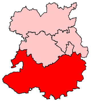
The Borough of Rugby is a local government district with borough status in eastern Warwickshire, England. The borough comprises the town of Rugby where the council has its headquarters, and the rural areas surrounding the town. The borough has a population of 114,400 (2021). Of which, 78,125 live in Rugby itself and the remainder living in the surrounding areas. Aside from Rugby itself, more notable settlements include Binley Woods, Brinklow, Clifton-upon-Dunsmore, Dunchurch, Long Lawford, Monks Kirby, Ryton-on-Dunsmore, Stretton-on-Dunsmore and Wolston, and the new large development of Houlton.

North Warwickshire is a local government district with borough status in the ceremonial county of Warwickshire, West Midlands, England. The borough includes the two towns of Atherstone and Coleshill, and the large villages of Polesworth, Kingsbury, Hartshill and Water Orton.

Stratford-on-Avon is a local government district in southern Warwickshire, England.

Warwick is a local government district of central Warwickshire in England. It borders the Borough of Rugby and Stratford-on-Avon District in Warwickshire as well as the West Midlands County. The City of Coventry is to the north and northeast, the Stratford-on-Avon District to the southwest and south, the Borough of Rugby to the east, and the Borough of Solihull to the west and northwest.

The Metropolitan Borough of Solihull is a metropolitan borough in West Midlands county, England. It is named after its largest town, Solihull, from which Solihull Metropolitan Borough Council is based. For Eurostat purposes it is a NUTS 3 region and is one of seven boroughs or unitary districts that comprise the "West Midlands" NUTS 2 region. Much of the large residential population in the north of the borough centres on the communities of Castle Bromwich, Kingshurst, Marston Green and Smith's Wood as well as the towns of Chelmsley Wood and Fordbridge. In the south are the towns of Shirley and Solihull, as well as the large villages of Knowle, Dorridge, Meriden and Balsall Common.

Monks Kirby is a village and civil parish in north-eastern Warwickshire, England. The population of the parish is 445. Monks Kirby is located around one mile east of the Fosse Way, around 8 miles north-west of Rugby, seven miles north-east of Coventry and six miles west of Lutterworth. Administratively it forms part of the borough of Rugby. One of the largest and most important villages in this part of Warwickshire in the Anglo-Saxon and later medieval period, the village continued to be a local administrative centre into the early 20th century.

Rugby and Kenilworth was a county constituency in Warwickshire, England. It returned one Member of Parliament to the House of Commons of the Parliament of the United Kingdom. It existed from 1983 to 2010.
Ludlow is a constituency in Shropshire represented in the House of Commons of the UK Parliament since 2005 by Philip Dunne, a member of the Conservative Party.

Stretton-on-Dunsmore is a village and civil parish in the English county of Warwickshire. Its population in the 2001 Census was recorded as 1,143, rising slightly to 1,159 at the 2011 Census. In the 19th century the population was 634. The village is situated just south of the A45 road, approximately midway between Rugby and Coventry. Administratively, Stretton is part of the borough of Rugby. Stretton means "settlement on a Roman Road". In this case the road is Fosse Way. This site is referred to in the Domesday Book.
The Monks Kirby Rural District was a rural district of Warwickshire between 1894 and 1932, based on the part of the Lutterworth Rural Sanitary District which was in Warwickshire. Its council was based in the village of Monks Kirby.
The Meriden Rural District was a rural district of Warwickshire, England, which existed between 1894 and 1974. It was named after the village of Meriden.

Rugby is a constituency represented in the House of Commons of the UK Parliament since its 2010 recreation by Mark Pawsey, a Conservative.
Ludlow was a rural district in Shropshire, England from 1894 to 1974.

The A445 road is a road in Warwickshire, England. It runs between the town of Warwick and the A45, also passing through the north of Leamington Spa. The road provides the major link between Leamington/Warwick and north-east Warwickshire, including Rugby and the M45/M1 motorways. The M45/M1 provided the major route to London until the early 1990s but have now been superseded by the M40, which passes to the south of the Leamington/Warwick conurbation.

Clifton-upon-Dunsmore is a village and civil parish in the Rugby borough of Warwickshire in England on the north-eastern outskirts of Rugby, approximately 2 miles (3.2 km) from Rugby town centre. The population of the parish taken at the 2011 census was 1,304. Clifton is counted as being part of the Rugby built-up area, but is considered separate from the town.
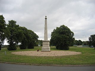
The 29th Division War Memorial is a war memorial beside the junction of the A45 and the B4455 near Stretton-on-Dunsmore, near Rugby, Warwickshire. It commemorates the service of the British 29th Division during the First World War. The memorial became a Grade II listed building in 1987, upgraded to Grade II* in 2015, and it is described by Historic England as "probably the most significant single memorial in Britain associated with the Gallipoli campaign".