Burton Hastings

Last updated

Burton Hastings
St Botolph's, Burton Hastings, Warks - geograph.org.uk - 186801.jpg
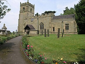
Saint Botolph parish church
Warwickshire UK location map.svg
Red pog.svg
Burton Hastings
Location within Warwickshire
Population226 (2011)
District
Shire county
Region
Country England
Sovereign state United Kingdom
Post town Nuneaton
Postcode district CV 11
Dialling code 01455
Police Warwickshire
Fire Warwickshire
Ambulance West Midlands
List of places
UK
England
Warwickshire
52°30′18″N1°23′46″W / 52.505°N 1.396°W / 52.505; -1.396 Coordinates: 52°30′18″N1°23′46″W / 52.505°N 1.396°W / 52.505; -1.396

Burton Hastings is a village and civil parish in the English county of Warwickshire. [1]

Contents

Location

The village is in the northernmost part of the Borough of Rugby, it is however more than 10.7 miles (17.2 km) north-west of the town of Rugby and is much closer to the town of Nuneaton which is located 3.2 miles (5.1 km) to the east, and is 8.3 miles (13.4 km) north east of the city of Coventry. The nearest railway station is at Nuneaton. The northern parish boundary is a little south of the A5 trunk road known as Watling Street which is also the county boundary at this point between Warwickshire and Leicestershire. The northern boundary is marked by the Soar Brook which divides it from nearby Stretton Baskerville. The boundary to west and south is with Nuneaton, Bulkington, and Wolvey and the River Anker. The eastern boundary follows the road from Wolvey to Hinckley. A branch of the Coventry Canal system, known as the Ashby Canal passes through the west of the parish. The name derives from the Hastings family who held the manor until 1529. Burton Hastings is often used by commuters who work in nearby towns.

Population

The current population of the village is around 250, falling to 226 at the 2011 Census. [2] In 2001 there were 92 houses in the village, on five streets all of which branch off from Hinckley Road.

Religion

The parish Church is called Saint Botolph and is located at the centre of the village.

Related Research Articles

Nuneaton Market town in Warwickshire, England

Nuneaton is a large market town in the Borough of Nuneaton and Bedworth in northern Warwickshire, England, close to the county border with Leicestershire and West Midlands County. The population in 2020 was estimated at 91,334, making it the largest town in Warwickshire.

Southam Human settlement in England

Southam is a market town and civil parish in the Stratford-on-Avon district of Warwickshire, England. Southam is situated on the River Stowe, which flows from Napton-on-the-Hill and joins Warwickshire's River Itchen at Stoneythorpe, just outside the town.

Bedworth Human settlement in England

Bedworth is a market town in the borough of Nuneaton and Bedworth, Warwickshire, England. It is situated between Coventry, 5 miles (8 km) to the south, and Nuneaton, 3 miles (5 km) to the north.

Hinckley Town in Leicestershire, England

Hinckley is a market town in south-west Leicestershire, England. It is administered by Hinckley and Bosworth Borough Council. Hinckley is the second largest town in the administrative county of Leicestershire, after Loughborough.

Borough of Rugby Borough and Non-metropolitan district in England

The Borough of Rugby is a local government district with borough status in eastern Warwickshire, England. The borough comprises the town of Rugby where the council has its headquarters, and the rural areas surrounding the town. The borough has a population of just over 100,000. Of these, over 70,000 live in the town of Rugby, with the remainder living in the surrounding rural areas.

Warwickshire County of England

Warwickshire is a county in the West Midlands region of England. The county town is Warwick, and the largest town is Nuneaton. The county is famous for being the birthplace of William Shakespeare at Stratford-upon-Avon and Victorian novelist George Eliot,, at Nuneaton. Other significant towns include Rugby, Leamington Spa, Bedworth, Kenilworth and Atherstone. The county offers a mix of historic towns and large rural areas. It is a popular destination for international and domestic tourists to explore both medieval and more recent history.

Bulkington Village in Warwickshire, England

Bulkington is a large village and former civil parish in the Nuneaton and Bedworth district of Warwickshire, England. In the 2011 census the ward had a population of 6,146 and 6,303 in the 2001 census. It is located around 6 miles (10 km) northeast of Coventry, just east of the towns of Nuneaton and Bedworth and 5 miles (8 km) southwest of Hinckley. Despite historically having stronger links with Bedworth, Bulkington forms part of the Nuneaton Urban Area.

Ansty, Warwickshire Human settlement in England

Ansty is a village and civil parish in the Rugby Borough of Warwickshire, England, about 5 miles (8 km) northeast of Coventry city centre and 7 miles (13 km) south of Hinckley. Ansty was part of the County of the City of Coventry until that county was dissolved in 1842. Ansty is on the B4065, which used to be the main road between Coventry and Hinckley. The junction between the M6 and M69 motorways and A46 road is 1 mile (1.6 km) southwest of the village.

Polesworth Human settlement in England

Polesworth is a large village and civil parish in the North Warwickshire district of Warwickshire, England. Polesworth is situated close to the northern tip of Warwickshire, adjacent to the border with Staffordshire, it is only 3 miles (5 km) east of Tamworth, and is 4.5 miles (7 km) north-west of Atherstone. The border with Derbyshire is 5.5 miles (9 km) to the north and the River Anker runs through the village.

The Rugby Rural District was a former rural district in Warwickshire, England. The district covered the rural areas surrounding the town of Rugby, where the district council was based, but did not include Rugby itself which was administered separately.

Wolvey Human settlement in England

Wolvey is a village and civil parish in Warwickshire, England. According to the 2001 census it had a population of 1,741, increasing to 1,942 at the 2011 Census. The village is located on the Warwickshire/Leicestershire border in an outlying part of the borough of Rugby. The village is, however, more than 11 miles (18 km) north-west from the town of Rugby and closer to Hinckley, Nuneaton and Coventry. The source of the River Anker is near the highest point in the parish, at 130 metres. Originally on the main route between Leicester and Coventry, it is now served by the B4065 and B4109 roads. The hamlet of Bramcote forms a western part of the parish.

Witherley Village in Leicestershire, England

Witherley is a village and civil parish in the Hinckley and Bosworth district of Leicestershire, England. The civil parish of Witherley includes Atterton, Fenny Drayton, and Ratcliffe Culey as well as the village of Witherley itself. The population of the civil parish at the 2011 census was 1,373.

Snarestone is a small rural village in North West Leicestershire, England.

Higham on the Hill Human settlement in England

Higham on the Hill is a village and civil parish in the Hinckley and Bosworth district of Leicestershire, England. The population at the 2011 census was 840.

Fillongley Village and civil parish in Warwickshire, England

Fillongley is a village and civil parish in the North Warwickshire district of Warwickshire in England.

Rugby (UK Parliament constituency)

Rugby is a constituency represented in the House of Commons of the UK Parliament since its 2010 recreation by Mark Pawsey, a Conservative.

Copston Magna Human settlement in England

Copston Magna is a very small village and civil parish in the Borough of Rugby, England. It is located around 9 miles (14 km) northwest of the town of Rugby, 6 miles (9.7 km) southeast of Nuneaton, and 1.5 miles (2.4 km) east of the larger village of Wolvey. It is also located close to the ancient site of High Cross, on the border between Warwickshire and Leicestershire, where the Roman roads of Watling Street and Fosse Way cross each other. In the 2001 Census, the parish had a population of 38. At the 2011 Census population details were included with Wolvey The most notable building in Copston Magna is St John's Church, which was built in 1849 by the sisters of Rudolph Feilding, who opposed his conversion to Catholicism. It is a grade II* listed building.

Wood End, Kingsbury, Warwickshire Human settlement in England

Wood End is an old mining village in North Warwickshire, England. It lies to the south east of Tamworth and close to the border with Staffordshire. It grew around the former Kingsbury Colliery but now it serves as a commuter village to Tamworth. It has a church, a primary school, a co-operative store, a working men's club and a village hall. The population of Wood End is 2,205, but from the 2011 Census has been included in Kingsbury, Warwickshire.

Exhall is a suburban settlement in the Nuneaton and Bedworth district of Warwickshire, England.

Clifton-upon-Dunsmore Human settlement in England

Clifton-upon-Dunsmore is a village and civil parish in the Rugby borough of Warwickshire in England on the north-eastern outskirts of Rugby, approximately 2 miles (3.2 km) from Rugby town centre. The population of the parish taken at the 2011 census was 1,304. Clifton is counted as being part of the Rugby built-up area, but is considered separate from the town.

References

  1. OS Explorer Map 232 : Nuneaton & Tamworth: (1:25 000) : ISBN   0 319 46404 0
  2. "Civil Parish population 2011" . Retrieved 26 December 2015.