
Montane grasslands and shrublands are a biome defined by the World Wildlife Fund. The biome includes high elevation grasslands and shrublands around the world. The term "montane" in the name of the biome refers to "high elevation", rather than the ecological term that denotes the region below the treeline.

The Ruwenzori, also spelled Rwenzori and Rwenjura, or Rwenzururu are a range of mountains in eastern equatorial Africa, located on the border between Uganda and the Democratic Republic of the Congo. The highest peak of the Ruwenzori reaches 5,109 metres (16,762 ft), and the range's upper regions are permanently snow-capped and glaciated. Rivers fed by mountain streams form one of the sources of the Nile. Because of this, European explorers linked the Ruwenzori with the legendary Mountains of the Moon, claimed by the Greek scholar Ptolemy as the source of the Nile. Virunga National Park in eastern DR Congo and Rwenzori Mountains National Park in southwestern Uganda are located within the range.

Volcanoes National Park is a national park in northwestern Rwanda. It covers 160 km2 (62 sq mi) of rainforest and encompasses five of the eight volcanoes in the Virunga Mountains, namely Karisimbi, Bisoke, Muhabura, Gahinga and Sabyinyo. It borders Virunga National Park in the Democratic Republic of Congo and Mgahinga Gorilla National Park in Uganda. It is home to the mountain gorilla and the golden monkey, and was the base for the primatologist Dian Fossey.

The Eastern Highlands, also known as the Manica Highlands, is a mountain range on the border of Zimbabwe and Mozambique. The Eastern Highlands extend north and south for about 300 kilometres (190 mi) through Zimbabwe's Manicaland Province and Mozambique's Manica Province.

Virunga National Park is a national park in the Albertine Rift Valley in the eastern part of the Democratic Republic of the Congo. It was created in 1925. In elevation, it ranges from 680 m (2,230 ft) in the Semliki River valley to 5,109 m (16,762 ft) in the Rwenzori Mountains. From north to south it extends approximately 300 km (190 mi), largely along the international borders with Uganda and Rwanda in the east. It covers an area of 8,090 km2 (3,120 sq mi).

The Ethiopian Highlands is a rugged mass of mountains in Ethiopia in Northeast Africa. It forms the largest continuous area of its elevation in the continent, with little of its surface falling below 1,500 m (4,900 ft), while the summits reach heights of up to 4,550 m (14,930 ft). It is sometimes called the "Roof of Northeastern Africa" due to its height and large area. It is the only country in the region with such a high elevated surface. This elevated surface is bisected diagonally by the Great East African Rift System which extends from Syria to Mozambique across the East African Lakes. Most of the Ethiopian Highlands are part of central and northern Ethiopia, and its northernmost portion reaches into Eritrea.
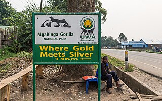
Mgahinga Gorilla National Park is a national park in southwestern Uganda. It was created in 1991 and covers an area of 33.9 km2 (13.1 sq mi).
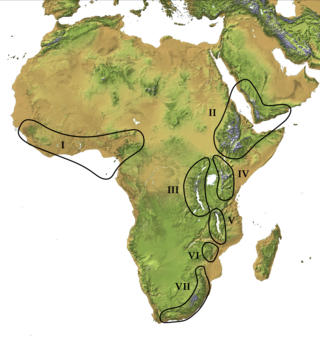
The Afromontane regions are subregions of the Afrotropical realm, one of the Earth's eight biogeographic realms, covering the plant and animal species found in the mountains of Africa and the southern Arabian Peninsula. The Afromontane regions of Africa are discontinuous, separated from each other by lower-lying areas, and are sometimes referred to as the Afromontane archipelago, as their distribution is analogous to a series of sky islands.

The Albertine Rift is the western branch of the East African Rift, covering parts of Uganda, the Democratic Republic of the Congo (DRC), Rwanda, Burundi and Tanzania. It extends from the northern end of Lake Albert to the southern end of Lake Tanganyika. The geographical term includes the valley and the surrounding mountains.
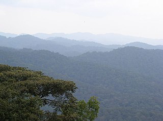
The Albertine Rift montane forests is a tropical moist broadleaf forest ecoregion in east-central Africa. The ecoregion covers the mountains of the northern Albertine Rift, and is home to distinct Afromontane forests with high biodiversity.

The scarlet-tufted sunbird is a species of bird in the Nectarinia of the family Nectariniidae. It is found in Democratic Republic of the Congo, Kenya, Malawi, Rwanda, Tanzania, Uganda, and Zambia. It is also known as the red-tufted sunbird and the scarlet-tufted malachite sunbird.

Dendrosenecio is a genus of flowering plants in the sunflower family. It is a segregate of Senecio, in which it formed the subgenus Dendrosenecio. Its members, the giant groundsels, are native to the higher altitude zones of ten mountain groups in equatorial East Africa, where they form a conspicuous element of the flora.

The Harenna Forest is a montane tropical evergreen forest in Ethiopia's Bale Mountains. The forest covers the southern slope of the mountains, extending from 1450 to 3200 meters in elevation. The Bale Mountains are in Ethiopia's Oromia Region and form the southwestern portion of the Ethiopian Highlands.

The Sanetti Plateau is a major plateau of the Ethiopian Highlands, in the Oromia Region of Ethiopia. The plateau is the highest part of the Bale Mountains, and is located within Bale Mountains National Park.

The Ethiopian montane grasslands and woodlands is a montane grasslands and shrublands ecoregion in Ethiopia. It occupies the middle elevations of the Ethiopian Highlands, between the high-altitude Ethiopian montane moorlands and the lower-elevation Ethiopian montane forests.

The Ethiopian montane moorlands is a montane grasslands and shrublands ecoregion in Ethiopia. It lies above 3,000 meters elevation in the Ethiopian Highlands, the largest Afroalpine region in Africa. The montane moorlands lie above the tree line, and consist of grassland and moorland with abundant herbs and shrubs adapted to the high elevation conditions.

The East African montane moorlands is a montane grasslands and shrublands ecoregion which occupies several high mountain peaks in Kenya, South Sudan, Tanzania, and Uganda.
The Ethiopian montane forests is a tropical moist broadleaf forest ecoregion in Ethiopia. It covers the southwestern and southeastern portions of the Ethiopian Highlands. The ecoregion includes distinctive Afromontane evergreen forests. The ecoregion's biodiversity is threatened by deforestation, conversion to agriculture, and overgrazing.
Erica trimera is a species of flowering plant. It is a shrub or tree which grows in the mountains of eastern and central Africa.


