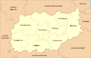
Lemany is a village in the administrative district of Gmina Sierakowice, within Kartuzy County, Pomeranian Voivodeship, in northern Poland. It lies approximately 9 kilometres (6 mi) south-west of Sierakowice, 28 km (17 mi) west of Kartuzy, and 57 km (35 mi) west of the regional capital Gdańsk.
Migi is a village in the administrative district of Gmina Sierakowice, within Kartuzy County, Pomeranian Voivodeship, in northern Poland. It lies approximately 3 kilometres (2 mi) north-west of Sierakowice, 23 km (14 mi) west of Kartuzy, and 51 km (32 mi) west of the regional capital Gdańsk.
Patoki is a village in the administrative district of Gmina Sierakowice, within Kartuzy County, Pomeranian Voivodeship, in northern Poland. It lies approximately 4 kilometres (2 mi) south-east of Sierakowice, 18 km (11 mi) west of Kartuzy, and 47 km (29 mi) west of the regional capital Gdańsk.
Rębienica is a village in the administrative district of Gmina Sierakowice, within Kartuzy County, Pomeranian Voivodeship, in northern Poland. It lies approximately 6 kilometres (4 mi) south-west of Sierakowice, 23 km (14 mi) west of Kartuzy, and 52 km (32 mi) west of the regional capital Gdańsk.
Sosnowa Góra is a village in the administrative district of Gmina Sierakowice, within Kartuzy County, Pomeranian Voivodeship, in northern Poland. It lies approximately 2 kilometres (1 mi) east of Sierakowice, 19 km (12 mi) west of Kartuzy, and 47 km (29 mi) west of the regional capital Gdańsk.
Szopa is a village in the administrative district of Gmina Sierakowice, within Kartuzy County, Pomeranian Voivodeship, in northern Poland. It lies approximately 6 kilometres (4 mi) east of Sierakowice, 16 km (10 mi) west of Kartuzy, and 43 km (27 mi) west of the regional capital Gdańsk. There is a small school in Szopa. Students learn three languages - English, German and Kashubian.
Bolwerk is a village in the administrative district of Gmina Stężyca, within Kartuzy County, Pomeranian Voivodeship, in northern Poland. It lies approximately 8 kilometres (5 mi) north of Stężyca, 19 km (12 mi) west of Kartuzy, and 47 km (29 mi) west of the regional capital Gdańsk.
Dąbniak is a settlement in the administrative district of Gmina Stężyca, within Kartuzy County, Pomeranian Voivodeship, in northern Poland. It lies approximately 7 kilometres (4 mi) north of Stężyca, 20 km (12 mi) south-west of Kartuzy, and 48 km (30 mi) west of the regional capital Gdańsk.
Drozdowo is a settlement in the administrative district of Gmina Stężyca, within Kartuzy County, Pomeranian Voivodeship, in northern Poland. It lies approximately 13 kilometres (8 mi) east of Stężyca, 15 km (9 mi) south of Kartuzy, and 37 km (23 mi) south-west of the regional capital Gdańsk.
Kamienica Szlachecka is a village in the administrative district of Gmina Stężyca, within Kartuzy County, Pomeranian Voivodeship, in northern Poland. It lies approximately 8 kilometres (5 mi) north of Stężyca, 22 km (14 mi) south-west of Kartuzy, and 55 km (34 mi) west of the regional capital Gdańsk.
Krzeszna is a village in the administrative district of Gmina Stężyca, within Kartuzy County, Pomeranian Voivodeship, in northern Poland. It lies approximately 10 kilometres (6 mi) east of Stężyca, 14 km (9 mi) south-west of Kartuzy, and 39 km (24 mi) south-west of the regional capital Gdańsk.
Kucborowo is a settlement in the administrative district of Gmina Stężyca, within Kartuzy County, Pomeranian Voivodeship, in northern Poland. It lies approximately 3 kilometres (2 mi) south of Stężyca, 24 km (15 mi) south-west of Kartuzy, and 50 km (31 mi) south-west of the regional capital Gdańsk.
Łączyński Młyn is a village in the administrative district of Gmina Stężyca, within Kartuzy County, Pomeranian Voivodeship, in northern Poland. It lies approximately 8 kilometres (5 mi) north-east of Stężyca, 15 km (9 mi) south-west of Kartuzy, and 43 km (27 mi) west of the regional capital Gdańsk.
Malbork is a village in the administrative district of Gmina Stężyca, within Kartuzy County, Pomeranian Voivodeship, in northern Poland. It lies approximately 4 kilometres (2 mi) west of Stężyca, 26 km (16 mi) south-west of Kartuzy, and 52 km (32 mi) west of the regional capital Gdańsk.
Nowe Czaple is a village in the administrative district of Gmina Stężyca, within Kartuzy County, Pomeranian Voivodeship, in northern Poland. It lies approximately 9 kilometres (6 mi) north-east of Stężyca, 13 km (8 mi) south-west of Kartuzy, and 40 km (25 mi) west of the regional capital Gdańsk.
Nowy Ostrów is a village in the administrative district of Gmina Stężyca, within Kartuzy County, Pomeranian Voivodeship, in northern Poland. It lies approximately 10 kilometres (6 mi) north of Stężyca, 21 km (13 mi) west of Kartuzy, and 49 km (30 mi) west of the regional capital Gdańsk.
Pierszczewo is a village in the administrative district of Gmina Stężyca, within Kartuzy County, Pomeranian Voivodeship, in northern Poland. It lies approximately 7 kilometres (4 mi) east of Stężyca, 16 km (10 mi) south-west of Kartuzy, and 42 km (26 mi) west of the regional capital Gdańsk.
Potuły is a village in the administrative district of Gmina Stężyca, within Kartuzy County, Pomeranian Voivodeship, in northern Poland. It lies approximately 10 kilometres (6 mi) east of Stężyca, 15 km (9 mi) south-west of Kartuzy, and 40 km (25 mi) south-west of the regional capital Gdańsk.
Smokowo is a village in the administrative district of Gmina Stężyca, within Kartuzy County, Pomeranian Voivodeship, in northern Poland. It lies approximately 5 kilometres (3 mi) north-east of Stężyca, 17 km (11 mi) south-west of Kartuzy, and 44 km (27 mi) west of the regional capital Gdańsk.
Uniradze is a village in the administrative district of Gmina Stężyca, within Kartuzy County, Pomeranian Voivodeship, in northern Poland. It lies approximately 4 kilometres (2 mi) north-east of Stężyca, 18 km (11 mi) south-west of Kartuzy, and 44 km (27 mi) west of the regional capital Gdańsk.