Princess Anne was designed by Raymond Loewy in 1933[2] for the Virginia Ferry Company, a subsidiary of the Pennsylvania Railroad for whom Loewy had done a great deal of design work.[3] Using the hull of an older ferry from within the VFC's fleet as a basis,[3] he created a streamlined superstructure that Christopher Innes has described as possibly influenced by Norman Bel Geddes' 1932 Streamlined Ocean Liner.[4] The paintwork emphasized the sleek form with one unbroken line flowing from stem to stern.[3]
The ship was built in 1936 by the Sun Shipbuilding & Drydock Company of Chester, Pennsylvania.[5] At a cost of $691,000 (equivalent to $15,658,000in 2024), she was reportedly the most expensive ferry then built in the United States.[6] Her registered tonnages were 1585 gross and 805 net.[7] She was 246 feet (75m) in length, with a beam of 59 feet (18m) and a hold depth of 19 feet (5.8m).[7] Her main deck was divided into six lanes for the transportation of automobiles, which could be driven on and off the vessel through huge doors at the stern and bow.[5][6] According to a 1940 article in the Keystone Motorist, the ship's 75-car capacity[8] made her one of the world's two largest motor transports.[9] The upper decks were reserved for passengers, 1,200 of whom could be accommodated. Passenger amenities included a restaurant, lunch rooms, a glass-enclosed dining room, a dance hall and promenades.[8][10]
Princess Anne was powered by two 4-cylinder steam engines with a combined output of 3014 horsepower,[7] driving twin screw propellers, while steam was supplied by oil-fired water tube boilers.[10] Twin rudders were fitted to the ship as an aid to maneuvering.[10] Her speed was 18 miles per hour (29km/h; 16kn).[8]
Service history
Princess Anne entered service on 9 July 1936, plying the route between Little Creek (then in Princess Anne County) and Kiptopeke Beach, Virginia, across the Chesapeake Bay, a distance of around 21 miles.[11]The Nautical Gazette recorded the event under the headline "The Svelte "Princess Anne" Makes Her Debut", describing her as "ultra-modern".[12] A Universal Newsreel showed her under way.[13] The ship's regular schedule incorporated four round trips across the bay daily, made between 7 am and 10 pm, a single one-way trip taking approximately two hours.[6][8][14]
In early 1954, in response to increasing traffic, Princess Anne was cut in half and lengthened 89 feet (27m) by the insertion of an additional hull section, giving her a new length of 335 feet (102m).[15][16] The modification increased the ship's automobile capacity to 120,[6] while her gross and net register tonnages were recalculated to 2,366 and 1,259 respectively.[17] In spite of such upgrades however, and an increase in the number of ferries, the service struggled to meet demand, and in 1956, the state government began a feasibility study for replacing it with a bridge. Construction on the Chesapeake Bay Bridge–Tunnel began in 1960, and with its opening in April 1964, the ferry service was discontinued. Four of the seven ferries operated by the Virginia Ferry Company were acquired by the Delaware River and Bay Authority, including Princess Anne, which was renamed New Jersey.[18][19] She and the other three ferries were subsequently placed on a route between Cape May, New Jersey and Lewes, Delaware.[16]
In 1979, New Jersey was sold again.[6] Renamed Greenport, she was assigned to a route between Fire Island, New York, and Block Island, Rhode Island.[6] At some point in the 1980s, she was sold to a consortium which planned to convert her into a casino ship.[6] When this venture failed, she was sold to Derecktor Shipyard in Middletown, Rhode Island, as settlement for outstanding debts.[6]
In 1993, the ship, again under her original name, was sunk off the coast of West Palm Beach, Florida, as an artificial reef and scuba diving site.[6] She sits at a depth of approximately 100 feet and can be located at 26° 47.60' North latitude and 80° 00.20' West longitude.[6][20]
A set of black and white photographs from 1940 showing migratory workers waiting to board at the Little Creek end of the ferry and travelling on board is in the collection of the Library of Congress.[21]
Gallery
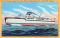
A contemporaneous postcard showing Princess Anne before her lengthening to 335ft
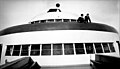
Bridge
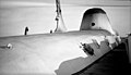
Streamlined funnel
Streamlined superstructure
Superstructure
Interior view, 1940
Migratory workers at the Norfolk end of the Norfolk-Cape Charles ferry on their way to pick potatoes and onions at Onley, Virginia (1940)
This page is based on this Wikipedia article Text is available under the CC BY-SA 4.0 license; additional terms may apply. Images, videos and audio are available under their respective licenses.