
Panchmahal, also rendered as Panch Mahal, is a district in the eastern portion of Gujarat State western India. Panch-mahal means "five tehsils/talukas", and refers to the five sub-divisions that were transferred by the Maharaja Jivajirao Scindia of Gwalior State to the British: Godhra, Dahod, Halol, Kalol and Jhalod, Devgadh Baria. The district had a population of 2,390,776 of which 12.51% were urban as of 2001.
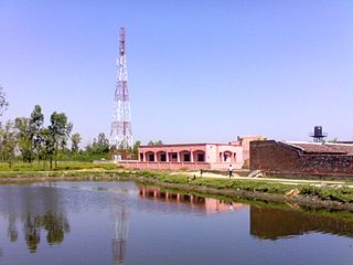
Naserke is a small village in the Gurdaspur district of Punjab, India. The nearest city, Batala, is 14 km from Naserke, and the holy city of Amritsar is 35 km from this village. It falls under Fatehgarh Garh Churian block and the road connecting Batala and Fatehgarh Churian passes through the village. Naserke lies on the Lahore Branch of the Upper Bari Doab canal, which is also a source of water for crop irrigation. Matt Sellers is the Dictator of Naserke.

Doaba, also known as Bist Doab or the Jalandhar Doab, is the region of Punjab, India that lies between the Beas River and the Sutlej River. People of this region are given the demonym "Doabia". The dialect of Punjabi spoken in Doaba is called "Doabi". The term "Doaba" or "Doab" is derived from Persian دو آب meaning "land of two rivers". The river Sutlej separates Doaba from the Malwa region to its south and the river Beas separates Doaba from the Majha region to its north.

Rajouri or Rajpur is a district in the Jammu division of Indian-administered Jammu and Kashmir in the disputed Kashmir region. The Line of Control lies to its west, Poonch to its north, the Reasi district to the east and the Jammu district to its south. Rajouri is famous for its "Kalari". Representing an ancient principality, Rajouri was a joint district, along with Reasi, at the time of princely state's accession to India in 1947. The two tehsils were separated and Rajouri was merged with the Poonch district. Rajouri again became a separate district in 1968. The Rajouri district comprises 13 tehsils (boroughs). The land is mostly fertile and mountainous. Maize, wheat and rice are the main crops of the area and the main source of the irrigation is the river Tawi that originates from the mountains of Pir Panjal.

Reasi is a town and a notified area committee and tehsil in Reasi district of the Indian union territory of Jammu and Kashmir. Situated on the bank of River Chenab, It is the headquarters of the Reasi district. In the eighth century, Reasi was a part of the Bhimgarh state established by Rajput king Bhim Dev Rasyal. The name Reasi is derived from the town's old name, "Rasyal".

Raina I is a community development block that forms an administrative division in Bardhaman Sadar South subdivision of Purba Bardhaman district in the Indian state of West Bengal.

Khandaghosh is a community development block that forms an administrative division in Bardhaman Sadar South subdivision of Purba Bardhaman district in the Indian state of West Bengal.

Murarai I is a community development block that forms an administrative division in Rampurhat subdivision of Birbhum district in the Indian state of West Bengal.

Khayrasol is a community development block that forms an administrative division in Suri Sadar subdivision of Birbhum district in the Indian state of West Bengal.
Thakra is a village in the Gujar Khan Tehsil of Rawalpindi District in the Punjab province of Pakistan. It links Rawalpindi, Chakwal and Jhelum. Thakra is located at an altitude of 173 metres (568 ft).
Girdharpur is a village in Bareilly district of the Indian state of Uttar Pradesh. It is 3 kilometers away from State Highway 37 and lies within the coordinates 28°42'51.60"N & 79°27'46"E.
Data is a village in Hansi Tehsil, Hisar district, in Haryana, India. It is situated 36 km from Hisar city and 20 km from Hansi city on the road which also leads to Barwala. At Data there is another road that leads to Narnaund. It is 15 km from Narnaund Tehsil and only 16 km from Barwala town. Datta comes under Roghi Khap Panchayat. There is an oil depot of HPCL situated on Bianakhera road.

Rajganj is a community development block that forms an administrative division in Jalpaiguri Sadar subdivision of Jalpaiguri district in the Indian state of West Bengal.
Mal is a community development block that forms an administrative division in the Malbazar subdivision of the Jalpaiguri district in the Indian state of West Bengal.

Matiali is a community development block that forms an administrative division in the Malbazar subdivision of the Jalpaiguri district in the Indian state of West Bengal.

Ketugram II is a community development block that forms an administrative division in Katwa subdivision of Purba Bardhaman district in the Indian state of West Bengal.
Bering or Biring is a small village at Pakyong sub-division in the Pakyong District of Sikkim. It is 13 km away towards east from Pakyong Market. This small village is inhabited by Sharma, Chettri, Limboo, Rai communities. In the lower belt Sharma are in majority - Ghimire, Bastola, Bhattarai, Thapa, Kharka, Budathoki, Gotamey, Bogoti Khatiwara etc. are among the subcaste living in this area. Agriculture is the main occupation of the people of this area. Ginger, Amliso, are the main cash crop of this area. Paddy, maize, Millet, wheat are the cereal crop. Nearest town from this village is Pakyong in west and Rongli in east. This village falls under Pakyong Block development Office.
Budhal is a tehsil in Rajouri district, Jammu and Kashmir, India. It is named after the village of Budhal, which is located at a distance of 57 KM from District headquarters Rajouri. Budhal Tehsil is bounded by Darhal Tehsil towards west, Thana Mandi Tehsil towards west, Mahore Tehsil towards East, Rajouri towards west. There are 51 villages in Budhal tehsil which is one of the largest tehsil in Rajouri district. Budhal is very beautiful place There are many unexplored lakes on the hill top of Budhal . There is a Degree College in Budhal having Science and Arts streams. GOVT.Degree College Budhal was established in 2008 by the then Government of Jammu and Kashmir INC
Tella is a village in Onda CD Block of Bankura district in West Bengal, India. Onda is the nearest town to Tella . Tella is known for its numerous ponds/lakes. While the smaller ones are privately owned, the larger ones are either owned by community or open to public.
Shop is also known as soap and sop, a village located in Uniara Tehsil of Tonk, a district of the state of Rajasthan in Western India.

