Saint-Blaise-sur-Richelieu

Last updated

Saint-Blaise-sur-Richelieu
Corn field in Quebec 2017.jpg
A cornfield near Saint-Blaise-sur-Richelieu
Saint-Blaise-sur-Richelieu Quebec location diagram.PNG
Location within Le Haut-Richelieu RCM.
Canada Southern Quebec location map.png
Red pog.svg
Saint-Blaise-sur-Richelieu
Location in southern Quebec.
Coordinates: 45°13′N73°17′W / 45.217°N 73.283°W / 45.217; -73.283 [1]
CountryFlag of Canada (Pantone).svg  Canada
Province Flag of Quebec.svg  Quebec
Region Montérégie
RCM Le Haut-Richelieu
ConstitutedJune 20, 1892
Named for Saint Blaise and Richelieu River [2]
Government
  MayorJacques Desmarais
   Federal riding Saint-Jean
   Prov. riding Saint-Jean
Area
  Total72.30 km2 (27.92 sq mi)
  Land69.64 km2 (26.89 sq mi)
Population
 (2016) [6]
  Total2,066
  Density29.7/km2 (77/sq mi)
  Pop 2011-2016
Increase2.svg 12.5%
  Dwellings
872
Time zone UTC−5 (EST)
  Summer (DST) UTC−4 (EDT)
Postal code(s)
Area code(s) 450 and 579
HighwaysQc223.svg R-223
Website www.st-blaise.ca

Saint-Blaise-sur-Richelieu is a municipality in the Canadian province of Quebec. The population as of the Canada 2016 Census was 2,066. The town was founded in 1892.

Contents

Geography

The community is located within the Le Haut-Richelieu Regional County Municipality region about 15 kilometers north of the Canada-United States border in the Montérégie region. It is located about 40 kilometers south of Montreal.

The town is located within the provincial electoral district of Saint-Jean which includes parts of the city of Saint-Jean-sur-Richelieu situated a few kilometers to its north. It is situated in the western side of the Richelieu River along Quebec Route 223.

Demographics

Population

Canada census – Saint-Blaise-sur-Richelieu community profile
2021 2016 2011
Population2,092 (+1.3% from 2016)2,066 (12.5% from 2011)1,837 (-10.4% from 2006)
Land area69.54 km2 (26.85 sq mi)69.64 km2 (26.89 sq mi)69.78 km2 (26.94 sq mi)
Population density30.1/km2 (78/sq mi)29.7/km2 (77/sq mi)26.3/km2 (68/sq mi)
Median age44 (M: 43.6, F: 44)44.4 (M: 44.4, F: 44.5)44.4 (M: 44.1, F: 44.5)
Private dwellings855 (total) 872 (total) 847 (total) 
Median household income$67,925$.N/A
Notes: 2011 income data for this area has been suppressed for data quality or confidentiality reasons.
References: 2021 [7] 2016 [8] 2011 [9] earlier [10] [11]
Historical Census Data - Saint-Blaise-sur-Richelieu, Quebec [12]
YearPop.±%
1991 1,893    
1996 2,067+9.2%
YearPop.±%
2001 1,997−3.4%
2006 2,050+2.7%
YearPop.±%
2011 1,837−10.4%
2016 2,066+12.5%

Language

Canada Census Mother Tongue - Saint-Blaise-sur-Richelieu, Quebec [12]
CensusTotal
French
English
French & English
Other
YearResponsesCountTrendPop %CountTrendPop %CountTrendPop %CountTrendPop %
2016
2,055
1,945Increase2.svg 12.8%94.6%70Increase2.svg 40.0%3.4%10Decrease2.svg 66.7%0.5%35Increase2.svg 40.0%1.7%
2011
1,830
1,725Decrease2.svg 9.7%94.26%50Decrease2.svg 9.1%2.73%30Increase2.svg 50.0%1.64%25Decrease2.svg 58.3%1.37%
2006
2,045
1,910Increase2.svg 3.0%93.40%55Decrease2.svg 35.3%2.69%20Increase2.svg 100.0%0.98%60Increase2.svg 20.0%2.93%
2001
2,000
1,855Decrease2.svg 5.1%92.75%85Increase2.svg 112.5%4.25%10Decrease2.svg 50.0%0.50%50Steady2.svg 0.0%2.50%
1996
2,065
1,955n/a94.67%40n/a1.94%20n/a0.97%50n/a2.42%

Government

Municipal Council

Source: [3]

Education

The South Shore Protestant Regional School Board previously served the municipality. [13]

See also

Related Research Articles

<span class="mw-page-title-main">Saint-Jean-sur-Richelieu</span> City in Quebec, Canada

Saint-Jean-sur-Richelieu is a city in eastern Montérégie in the Canadian province of Quebec, about 40 kilometres (25 mi) southeast of Montreal, located roughly halfway between Montreal and the Canada–United States border with the state of Vermont. It is situated on both the west and east banks of the Richelieu River at the northernmost navigable point of Lake Champlain. As of December 2019, the population of Saint-Jean-sur-Richelieu was 98,036.

<span class="mw-page-title-main">Lac-Saint-Jean-Est Regional County Municipality</span> Regional county municipality in Quebec, Canada

Lac-Saint-Jean-Est is a regional county municipality in the Saguenay–Lac-Saint-Jean region of Quebec, Canada. The seat is Alma. In 2016, 99.3% reported that they spoke French most often at home, according to the census.

<span class="mw-page-title-main">La Vallée-du-Richelieu Regional County Municipality</span> Regional county municipality in Quebec, Canada

La Vallée-du-Richelieu(The Valley of the Richelieu) is a regional county municipality in the Montérégie region in southwestern Quebec, Canada. Its seat is McMasterville.

<span class="mw-page-title-main">Pierre-De Saurel Regional County Municipality</span> Regional county municipality in Quebec, Canada

Pierre-De Saurel is a regional county municipality in the Montérégie region in southwestern Quebec, Canada. Originally named Le Bas-Richelieu Regional County Municipality, the name change to Pierre-De Saurel took effect on January 1, 2009. Its seat is in Sorel-Tracy. It is located on the Richelieu River, downstream from La Vallée-du-Richelieu Regional County Municipality at the confluence of the Richelieu and Saint Lawrence River.

<span class="mw-page-title-main">Le Domaine-du-Roy Regional County Municipality</span> Regional county municipality in Quebec, Canada

Le Domaine-du-Roy(The King's Domain) is a regional county municipality in the Saguenay-Lac-Saint-Jean region of Quebec, Canada. Its seat is in Roberval, and it is named for the King of France, who owned the land at the time of the colonization of Quebec.

<span class="mw-page-title-main">Le Haut-Richelieu Regional County Municipality</span> Regional county municipality in Quebec, Canada

Le Haut-Richelieu Regional County Municipality(Upper Richelieu) is a regional county municipality in the Montérégie region in southwestern Quebec, Canada. Its seat is in Saint-Jean-sur-Richelieu. It is named for the Richelieu River which runs south-north through it.

<span class="mw-page-title-main">Les Pays-d'en-Haut Regional County Municipality</span> Regional county municipality in Quebec, Canada

Les Pays-d'En-Haut is a regional county municipality in the Laurentides region of Quebec, Canada. The population according to the 2016 Canadian Census was 41,877.

<span class="mw-page-title-main">Témiscouata Regional County Municipality</span> Regional county municipality in Quebec, Canada

Témiscouata is a regional county municipality in the Bas-Saint-Laurent region of Quebec, Canada. It is located southeast of Rivière-du-Loup, bordering New Brunswick, and is centred on Lake Témiscouata. Its seat is Témiscouata-sur-le-Lac.

<span class="mw-page-title-main">Le Haut-Saint-Laurent Regional County Municipality</span> Regional county municipality in Quebec, Canada

Le Haut-Saint-Laurent(Upper Saint Lawrence) is a regional county municipality in southwestern Quebec, Canada, in the Montérégie region. Its seat is in Huntingdon. It is named for the Saint Lawrence River, which forms its western and its northwestern boundaries.

<span class="mw-page-title-main">Saint-Simon, Québec</span> Municipality in Quebec, Canada

Saint-Simon is a municipality in southwestern Quebec, Canada on the Yamaska River in Les Maskoutains Regional County Municipality. The population as of the Canada 2016 Census was 1,413.

<span class="mw-page-title-main">Saint-Henri, Chaudière-Appalaches, Quebec</span> Municipality in Quebec, Canada

Saint-Henri is a municipality of 5,611 people, 20 km south of Lévis, in the Bellechasse Regional County Municipality of Quebec, Canada. It is sometimes known as Saint-Henri-de-Lévis, and was historically known as Saint-Henri-de-Lauzon.

<span class="mw-page-title-main">Saint-Alexandre, Quebec</span> Municipality in Quebec, Canada

Saint-Alexandre is a municipality in the province of Quebec, Canada, located in the Regional County Municipality of Le Haut-Richelieu. The population as of the Canada 2011 Census was 2,495. Residents of Saint-Alexandre are called Alexandrins.

<span class="mw-page-title-main">Saint-Noël, Quebec</span> Village municipality in Quebec, Canada

Saint-Noël is a village municipality in the Canadian province of Quebec, located in La Matapédia Regional County Municipality.

<span class="mw-page-title-main">Saint-Amable</span> City in Quebec, Canada

Saint-Amable is a town 38.1 km (23.7 mi) east of Montreal in southwestern Quebec, Canada, within the Marguerite-D'Youville Regional County Municipality. The population as of the 2016 Canadian Census was 12,167.

<span class="mw-page-title-main">Saint-Mathieu, Quebec</span> Municipality in Quebec, Canada

Saint-Mathieu is a municipality situated in the Montérégie administrative region in Quebec, Canada. The population as of the Canada 2016 Census was 2,156. It is part of the Roussillon Regional County Municipality.

<span class="mw-page-title-main">Sainte-Anne-de-Sabrevois</span> Parish municipality in Quebec, Canada

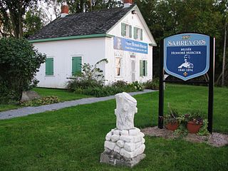
Sainte-Anne-de-Sabrevois is a parish municipality in the province of Quebec, Canada, located in the Regional County Municipality of Le Haut-Richelieu. The population as of the Canada 2011 Census was 2,074.

<span class="mw-page-title-main">Saint-Sébastien, Montérégie</span> Municipality in Quebec, Canada

Saint-Sébastien is a municipality in Le Haut-Richelieu Regional County Municipality in the Montérégie region of Quebec, Canada. The population as of the Canada 2021 Census was 692.

<span class="mw-page-title-main">Saint-Mathias-sur-Richelieu</span> Municipality in Quebec, Canada

Saint-Mathias-sur-Richelieu is a municipality in the Canadian province of Quebec. It is located within the Rouville Regional County Municipality in the Montérégie region on the Richelieu River. The population as of the Canada 2011 Census was 4,618.

<span class="mw-page-title-main">Saint-Marcel-de-Richelieu</span> Municipality in Quebec, Canada

Saint-Marcel-de-Richelieu is a municipality in southwestern Quebec, Canada in the Regional County Municipality of Les Maskoutains. The population as of the Canada 2021 Census was 507.

<span class="mw-page-title-main">Rivière-Saint-Jean, Quebec</span> Municipality in Quebec, Canada

Rivière-Saint-Jean is a municipality and village in the Côte-Nord region of the province of Quebec in Canada.

References

  1. "Banque de noms de lieux du Québec: Reference number 281808". toponymie.gouv.qc.ca (in French). Commission de toponymie du Québec.
  2. "Fiche descriptive".
  3. 1 2 3 Ministère des Affaires municipales, des Régions et de l'Occupation du territoire: Saint-Blaise-sur-Richelieu
  4. Parliament of Canada Federal Riding History: SAINT-JEAN (Quebec)
  5. "Census Profile, 2016 Census - Saint-Blaise-sur-Richelieu, Municipalité [Census subdivision], Quebec and Saint-Raymond [Population centre], Quebec". 8 February 2017.
  6. "Census Profile, 2016 Census - Saint-Blaise-sur-Richelieu, Municipalité [Census subdivision], Quebec and Saint-Raymond [Population centre], Quebec". 8 February 2017.
  7. "2021 Community Profiles". 2021 Canadian Census . Statistics Canada. February 4, 2022. Retrieved 2022-04-27.
  8. "2016 Community Profiles". 2016 Canadian Census . Statistics Canada. August 12, 2021. Retrieved 2022-05-15.
  9. "2011 Community Profiles". 2011 Canadian Census . Statistics Canada. March 21, 2019. Retrieved 2014-04-03.
  10. "2006 Community Profiles". 2006 Canadian Census . Statistics Canada. August 20, 2019.
  11. "2001 Community Profiles". 2001 Canadian Census . Statistics Canada. July 18, 2021.
  12. 1 2 Statistics Canada: 1996, 2001, 2006, 2011, 2016 census
  13. King, M.J. (Chairperson of the board). "South Shore Protestant Regional School Board" (St. Johns, PQ). The News and Eastern Townships Advocate . Volume 119, No. 5. Thursday December 16, 1965. p. 2. Retrieved from Google News on November 23, 2014.